Infographics
.png)
Science & Technology
Amplifying the Global Value of Earth Observation
For Prelims: Earth Observation Data, Greenhouse Gas Emissions, Artificial intelligence (AI), Indian Space Research Organisation, VEDAS, Earth Observation satellites, Early warning systems
For Mains: Economic impact of Earth Observation (EO) Data, Environmental benefits of EO, Managing natural resources and hazards.
Why in News?
Recently, a new report titled “Amplifying the Global Value of Earth Observation” by the World Economic Forum has shed light on the immense potential of Earth Observation (EO) data to drive economic growth and sustainability worldwide.
Note
Earth observation data involves collecting, analysing, and presenting information about the Earth's physical, chemical, and biological systems using remote sensing technologies.
- It involves acquiring information about the Earth's surface, such as land cover, oceans, agriculture, and forestry, through energy emission and processing of reflected images.
- It is achieved through remote sensing, which is a geospatial technology that collects data about an object, place, or phenomenon without making physical contact with it.
What are the Key Highlights of the Report?
- Potential Economic Impact of EO Data: EO data could generate over USD 3 trillion in economic benefits globally by 2030.
- The global value of EO data is expected to grow from USD 266 billion currently to over USD 700 billion by 2030.
- This could contribute a cumulative USD 3.8 trillion to the global Gross Domestic Product (GDP) by 2030.
- Environmental Benefits: EO data can help eliminate 2 gigatonnes of greenhouse gas emissions annually by 2030.
- This is equivalent to the estimated combined annual emissions of 476 million gasoline-powered cars.
- EO can monitor climate variables, emissions, ecosystems, and biodiversity to inform actions to mitigate climate change and protect natural habitats.
- Regional Opportunities: The Asia Pacific region is poised to capture the largest share of EO's value by 2030, reaching a potential value of USD 315 billion.
- Africa and South America are positioned to realise the largest percentage growth in EO data value.
- EO Blended with Enabling Technologies: Enabling technologies like artificial intelligence (AI) and digital twins can catalyse the adoption of EO data.
- A digital twin is a virtual representation of an object or system that accurately reflects a physical object. It covers the object's entire lifecycle, is updated with real-time data, and utilises simulation, machine learning, and reasoning to aid in decision-making.
What are the Key Areas of Application of Earth Observation Data?
- Environmental Monitoring and Management: Monitoring deforestation and illegal logging activities in the forests like Amazon rainforest using satellite imagery.
- Tracking the spread of deserts and monitoring desertification in regions like the Sahara.
- Monitoring the coastal areas and marine ecosystems, such as coral reef bleaching and oil spills.
- Agriculture and Precision Farming: Using multispectral imagery to monitor crop. health, estimate yields, and optimise precision agriculture practices for crops like wheat, rice, and corn.
- Assessing soil moisture levels in agricultural fields and identifying areas requiring irrigation in regions prone to drought.
- Detecting and mapping the spread of pests and diseases affecting crops.
- Urban Planning and Development: Mapping urban areas and monitoring urban sprawl in rapidly growing cities like Shanghai(China) and Mumbai(India).
- Identifying suitable locations for infrastructure development, such as new roads, airports, and housing projects.
- Monitoring changes in land use patterns and urban growth in megacities like Tokyo (Japan).
- Natural Resource Management: Mapping and monitoring mineral resources and mining activities in regions like the Permian Basin in the US (second-largest shale gas producing region in the US).
- Monitoring water resources, such as lakes, rivers, and groundwater levels in areas prone to water scarcity, like parts of Africa and the Middle East.
- Climate Change Studies: Monitoring changes in glaciers, sea ice, and polar regions, such as the Arctic and Antarctic.
- Tracking global temperatures and atmospheric conditions, including greenhouse gas emissions and their impact on climate.
- Disaster Management and Emergency Response: Assessing the extent of damage caused by natural disasters like hurricanes, earthquakes, and wildfires.
- Identifying areas affected by disasters for targeted relief efforts, such as the 2004 Indian Ocean tsunami.
- Defence and Security: Monitoring borders and detecting unauthorised activities, such as illegal border crossings and smuggling operations.
- Tracking troop movements and military activities during conflicts and tensions, like the Russia-Ukraine war.
- Archaeology and Cultural Heritage: Identifying and mapping archaeological sites and ancient structures, like the ancient Maya civilization.
- Monitoring the preservation of historical sites and cultural heritage.
How does India handle Earth Observation Data?
- About: Earth Observation (EO) data in India plays a crucial role in various applications ranging from disaster management to environmental monitoring.
- The Indian Space Research Organisation (ISRO) has been at the forefront of deploying satellites for EO purposes.
- Satellites:
- ISRO operates a series of Earth Observation satellites, including the recent EOS-07 launched in February 2023, and EOS-06 in November 2022.
- These satellites join the well-established fleet of RESOURCESAT series for land observation, and OCEANSAT series for ocean monitoring, providing a comprehensive suite of space-based tools for studying and managing our planet.
- EO Platforms:
- VEDAS (Visualisation of Earth Observation Data and Archival System): VEDAS is an initiative by the Space Applications Centre (SAC) of ISRO. It provides access to a vast repository of thematic spatial data derived from satellite imagery
- Bhuvan: It is ISRO’s geo-platform providing satellite imagery and thematic datasets for India.
- MOSDAC (Meteorological and Oceanographic Satellite Data Archival Centre): It is a data repository for all the meteorological missions of ISRO.
- Future Projects:
- NASA-ISRO Synthetic Aperture Radar (NISAR): It is a joint project between the National Aeronautics and Space Administration (NASA) and the ISRO to develop and launch an Earth-observing satellite with dual-frequency synthetic aperture radar.
- The satellite will be the first radar imaging satellite to use dual frequencies.
- Synthetic aperture radar (SAR) refers to a technique for producing fine-resolution images from a resolution-limited radar system.
- NISAR's data can help people worldwide better manage natural resources and hazards, as well as provide information for scientists to better understand the effects and pace of climate change.
- The satellite will be the first radar imaging satellite to use dual frequencies.
- NASA-ISRO Synthetic Aperture Radar (NISAR): It is a joint project between the National Aeronautics and Space Administration (NASA) and the ISRO to develop and launch an Earth-observing satellite with dual-frequency synthetic aperture radar.
What are the Key Facts About WEF?
- About: The World Economic Forum is an international organisation based in Geneva, Switzerland, founded by Klaus Schwab in 1971.
- History: It originally focused on management but expanded to economic and social issues in 1973.
- In 1973, the Annual Meeting of the European Management Forum expanded its focus to include economic and social issues due to events such as the collapse of the Bretton Woods fixed exchange rate mechanism and the Arab-Israeli War.
- In 1987, the European Management Forum officially became the World Economic Forum and aimed to provide a platform for dialogue. In 2015, the Forum was formally recognized as an international organisation.
- Annual Meeting: WEF promotes stakeholder capitalism and hosts the annual meeting in Davos, with around 3,000 participants discussing global issues from various sectors including investors, business leaders, political leaders, economists, celebrities, and others.
- The WEF is largely funded by its partnering corporations, which are generally global enterprises with annual turnovers exceeding USD 5 billion.
- Major Reports: Global Competitiveness Report, Global Gender Gap Report, Energy Transition Index, Global Risk Report, and Global Travel and Tourism Report.
|
Drishti Mains Question: Q. Evaluate India's role in utilising Earth Observation data for disaster management and environmental monitoring, considering ISRO's contributions and future projects. |
UPSC Civil Services Examination, Previous Year Questions (PYQs)
Prelims
Q1. Which of the following gives ‘Global Gender Gap Index’ ranking to the countries of the world? (2017)
(a) World Economic Forum
(b) UN Human Rights Council
(c) UN Women
(d) World Health Organization
Ans: (a)
Q2. Who among the following is the founder of World Economic Forum? (2009)
(a) Klaus Schwab
(b) John Kenneth Galbraith
(c) Hobert Zoellick
(d) Paul Krugman
Ans (a)
Q3. The Global Competitiveness Report is published by the (2019)
(a) International Monetary Fund
(b) United Nations Conference on Trade and Development
(c) World Economic Forum
(d) World Bank
Ans: (c)


Indian Economy
Regional Economic Outlook for Asia And Pacific Report: IMF
For Prelims: IMF, Special Drawing Rights, World Economic Outlook, International Monetary Fund (IMF), Inflation, World Bank (WB).
For Mains: Important International Institutions, Reports, Agencies and Further Structure, Mandate etc.
Why in News?
Recently, the International Monetary Fund (IMF) has released its Regional Economic Outlook for Asia And Pacific Report April 2024, which stated that India was the source of repeated positive growth surprises, supported by resilient domestic demand. Also, Public Investment is a significant factor in driving India’s economy.
What are the Key Highlights of the Report?
- Growth in Asia-Pacific: Asia-Pacific's growth in late 2023 surpassed expectations at 5.0%, with varying inflation rates across economies.
- Projections for 2024 suggest a slight growth slowdown to 4.5%, balancing near-term risks.
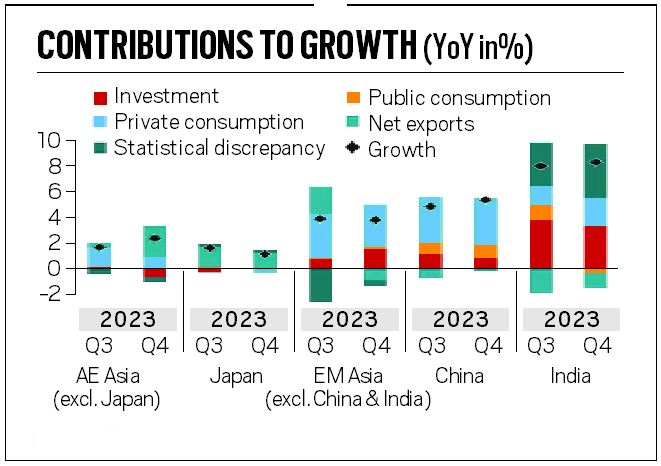
- In emerging markets, growth was supported primarily by strong private demand.
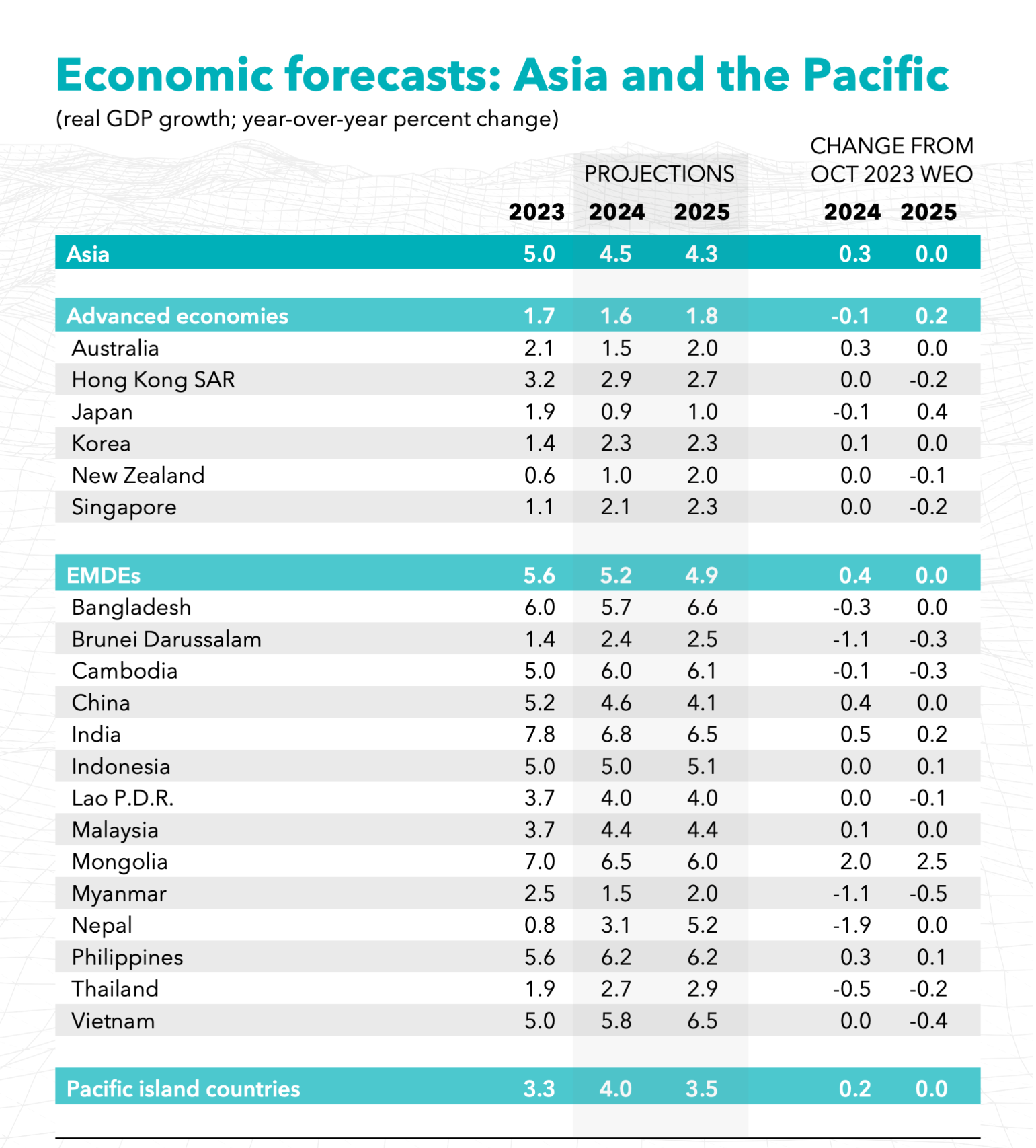
- India’s Growth Forecasts: It raised India’s growth forecast for the financial year 2024-25 to 6.8% from 6.5% earlier and retained the growth forecast for 2025-26 at 6.5%.
- It stated that India and the Philippines have been the source of repeated positive growth surprises, supported by resilient domestic demand.
- In China and, especially, India, public investment made an important contribution.
- Forecast for China: The Chinese Economy is expected to grow at the rate of 4.6% in 2024, slower from 5.2% in 2023 and expected to remain at 4.1% in 2025.
- The IMF sees China as a source of both upside and downside risks.
- Policies addressing stresses in the property sector and boosting domestic demand will benefit China and the region, as this sector is under stress due to concerns about a potential housing bubble (rapid rise in prices) and high levels of debt.
- However, sectoral policies leading to excess capacity in certain industries, such as steel and aluminium, will harm China and the region.
- The IMF sees China as a source of both upside and downside risks.
- Inflation Forecast: The IMF stated that inflation is currently at or near the desired level in emerging markets, but there are different factors contributing to inflation in the future.
- Core inflation is expected to stay low, but some economies may see a decrease in headline inflation due to lower energy prices.
- However, in countries like India, food prices, particularly for rice, can increase headline inflation.
- Inflation, as defined by the International Monetary Fund, is the rate of increase in prices over a given period, encompassing a broad measure of overall price increases or for specific goods and services.
- Headline Inflation: It considers the price changes of all the goods and services. This basket includes everything from food and energy to clothing, rent, and entertainment.
- Core Inflation: This is change in price of goods and services excluding food and energy sectors(as they are volatile).
- Core Inflation= Headline Inflation- Food and Fuel Items
- Inflation, as defined by the International Monetary Fund, is the rate of increase in prices over a given period, encompassing a broad measure of overall price increases or for specific goods and services.
- Geoeconomic Fragmentation: IMF has highlighted Geoeconomic fragmentation as a significant risk.
- Geoeconomic fragmentation refers to the risk of increasing economic and trade tensions between countries, which can have negative impacts on global economic growth and stability.
- Global disputes increase the trade risks, as shown by ships being redirected around Africa to bypass the Red Sea, leading to higher shipping expenses.
- IMF suggested that policymakers should be cautious to not aggravate trade frictions themselves.
How Public Investment is Key to Growth of India?
- About: Public investment refers to the allocation of government funds towards critical sectors such as infrastructure, education, healthcare, and technology.
- It plays a pivotal role in shaping a nation’s economic trajectory.
- Public Sector as Key to India’s Growth:
- Infrastructure Development: Public investment is vital for building and maintaining critical infrastructure, such as roads, highways, railways, ports, airports, and power plants, which are essential for economic growth and productivity.
- This sector will require estimated investments of USD4.5 trillion by 2030, which underscores the need for increased public investment in this sector.
- Job Creation and Poverty Alleviation: Public investment in infrastructure projects, social welfare schemes, and rural development initiatives can create employment opportunities and contribute to poverty alleviation.
- The Mahatma Gandhi National Rural Employment Guarantee Act (MGNREGA), for instance, has generated billions of person-days of employment since its inception.
- Human Capital Development: Public investment in education, healthcare, and skill development is crucial for building a skilled and productive workforce, which is essential for sustained economic growth.
- Also, public investment ensures balanced development across regions. It reduces disparities and promotes inclusive growth.
- Crowding-in Private Investment: Public investment in infrastructure and other productive sectors can create a favourable environment for private investment by reducing the cost of doing business and enhancing overall productivity.
- Infrastructure Development: Public investment is vital for building and maintaining critical infrastructure, such as roads, highways, railways, ports, airports, and power plants, which are essential for economic growth and productivity.
What is IMF?
- About: The International Monetary Fund (IMF) is an international organisation that provides financial assistance and advice to member countries.
- It was conceived during the Bretton Woods Conference in July 1944.
- Objectives:
- Foster global monetary cooperation and stability.
- Ensure financial stability and provide crisis assistance.
- Facilitate international trade with stable currencies.
- Promote sustainable growth and employment through effective policies.
- Board of Governors: The Board of Governors of the IMF includes one Governor and one Alternate Governor from each member country.
- In the case of India, the Finance Minister serves as the ex-officio Governor on the Board of Governors, and Governor of the Reserve Bank of India acting as India's Alternate Governor.
- Special Drawing Rights: The IMF issues an international reserve asset known as Special Drawing Rights, that can supplement the official reserves of member countries.
- Total global allocations are currently about USD 293 billion. IMF members can voluntarily exchange SDRs for currencies among themselves.
- Reports Published by IMF:
What is the Significance of the IMF for India?
- About: India joined the IMF as a founding member in December 1945, even before gaining independence.
- Currently, India holds a 2.75% Special Drawing Rights quota and 2.63% of votes in the IMF.
- SDR is one of the components of the Foreign Exchange Reserves (FER) of India
- IMF has made an allocation of Special Drawing Rights 12.57 billion to India. (approx USD 17.86 billion).
- Currently, India holds a 2.75% Special Drawing Rights quota and 2.63% of votes in the IMF.
- Significance:
- Independence of the Indian Rupee: Before the establishment of the IMF, the Indian rupee was linked with the British Pound Sterling.
- But the Indian rupee has become independent after the establishment of the IMF. Its value is expressed in terms of gold.
- It means that the Indian rupee is easily convertible into the currency of any other country.
- Availability of Foreign Currencies: The Government of India has been purchasing foreign currencies from the Fund from time to time to meet the requirements of development activities.
- From the inception of the IMF up to 31st March, 1971, India purchased foreign currencies of the value of Rs. 817.5 crores from the IMF, and the same have been fully repaid.
- Since 1970, the assistance that India, as other member countries of the IMF, can obtain from it has been increased through the setting up of the Special Drawing Rights (SDRs created in 1969).
- Help During Emergency: India has got a large amount of financial assistance from the Fund to solve its economic crisis arising due to natural calamities like flood, earthquakes, famines etc.
- In 1981 India was able to procure a massive loan of Rs. 5000 crores from IMF to overcome the balance of payments problem faced by it.
- Independence of the Indian Rupee: Before the establishment of the IMF, the Indian rupee was linked with the British Pound Sterling.
Which Sunrise Sectors in India are Seeking Substantial Public Investments?
- Carbon Capture, Utilization, and Storage (CCUS): CCUS technologies can play a crucial role in mitigating greenhouse gas emissions, particularly from industries like steel, cement, and power generation.
- However, public investment in research, development, and deployment of CCUS projects in India is currently limited.
- Cybersecurity and Data Protection: With the increasing digitalization of the economy and the rise of cyber threats, public investment is needed to enhance India's cybersecurity infrastructure, develop robust data protection frameworks, and build a skilled workforce in this domain.
- Biotechnology and Precision Medicine: Public investment in biotechnology research, particularly in areas like genomics, synthetic biology, and precision medicine, can help India develop cutting-edge healthcare solutions and position itself as a leader in this field.
- Circular Economy and Waste Management: While some initiatives have been taken, more public investment is required to develop a comprehensive circular economy framework, including infrastructure for waste collection, recycling, and resource recovery.
- Blue Economy and Marine Research: With India's vast coastline, public investment in marine research, sustainable ocean exploration, and the development of a blue economy focused on sectors like offshore wind energy, marine biotechnology, and coastal tourism could unlock significant economic opportunities.
|
Drishti Mains Question: Discuss the role of the International Monetary Fund (IMF) in promoting global economic stability and its impact on developing countries. Evaluate the criticisms against the IMF's policies and suggest potential reforms to address these concerns. |
UPSC Civil Services Examination, Previous Year Question (PYQ)
Prelims
Q1. "Rapid Financing Instrument" and "Rapid Credit Facility" are related to the provisions of lending by which one of the following? (2022)
(a) Asian Development Bank
(b) International Monetary Fund
(c) United Nations Environment Programme Finance Initiative
(d) World Bank
Ans: (b)
Q2. “Gold Tranche” (Reserve Tranche) refers to (2020)
(a) a loan system of the World Bank
(b) one of the operations of a Central Bank
(c) a credit system granted by WTO to its members
(d) a credit system granted by IMF to its members
Ans: (d)
Q3. ‘Global Financial Stability Report’ is prepared by the (2016)
(a) European Central Bank
(b) International Monetary Fund
(c) International Bank for Reconstruction and Development
(d) Organization for Economic Cooperation and Development
Ans: (b)
Mains
Q. The World Bank and the IMF, collectively known as the Bretton Woods Institutions, are the two inter-governmental pillars supporting the structure of the world’s economic and financial order. Superficially, the World Bank and the IMF exhibit many common characteristics, yet their role, functions and mandate are distinctly different. Elucidate. (2013)


Biodiversity & Environment
Mining in Aravalli Range
For Prelims: Aravalli ecosystems, Forest Survey of India (FSI), Great Indian Bustard, Supreme Court, Thar desert
For Mains: Key facts about the Aravalli Range, Key concerns related to the mining in the Aravalli Range
Why in News?
Recently, the Supreme Court has stopped the issuance of new mining licenses and renewals for existing ones in the Aravalli ranges and hills based on a report by the Forest Survey of India (FSI).
- Haryana's revenue from legal mining has significantly increased in the past decade (Rs 5.15 crore in 2013-14 to Rs 363.5 crore in 2023-24).
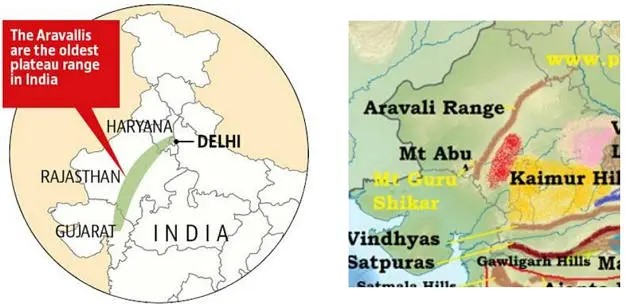
What are the Key Facts About the Aravalli Range?
- About:
- The Aravallis are one of the oldest fold residual mountains of the world comprised primarily of folded rock strata. This formation resulted from the convergence of tectonic plates during the Proterozoic Era (2500-541 million years ago)
- The Forest Survey of India (FSI) report, defined the Aravallis to include the hills and a uniform 100-meter-wide buffer zone around the downsides of the hills.
- They have an elevation of 300m to 900m. The mountains are divided into two main ranges – the Sambhar Sirohi Range and the Sambhar Khetri Range in Rajasthan.
- Guru Shikhar Peak on Mount Abu is the highest peak in the Aravalli Range (1,722 m).
- Major tribal communities include the Bhil, Bhil-Meena, Meena, Garasia, and others.
- The Supreme Court in 2009 ordered a complete ban on mining in the Aravalli hills of Faridabad, Gurgaon, and Nuh districts of Haryana.
- Significance:
- Rich in Biodiversity:
- It provides habitat to 300 native plant species, 120 bird species and many exclusive animals like the jackal and mongoose.
- Checks Desertification:
- The Aravallis act as a barrier between the fertile plains in the east and the Thar desert in the west.
- The excessive mining in the Aravalli Range is linked to the spread of the Thar Desert.
- The presence of loess, a desert windblown sediment, found in Mathura and Agra suggests that the desert is expanding due to the weakened ecological barrier created by the degraded Aravalli Hills.
- Impacts Climate:
- The Aravalli Range plays a significant role in shaping the climate of northwest India . During the monsoon season, these mountains act as a climatic barrier, guiding moisture-laden southwesterly winds towards Shimla and Nainital.
- This, in turn, helps nourish the sub-Himalayan rivers and contributes to the rainfall that replenish the vast north Indian plains.
- In the winter months, it protects the fertile alluvial river valleys from the cold westerly winds from Central Asia.
- The Aravalli Range plays a significant role in shaping the climate of northwest India . During the monsoon season, these mountains act as a climatic barrier, guiding moisture-laden southwesterly winds towards Shimla and Nainital.
- Rich in Biodiversity:
What are the Key Concerns Related to the Mining in the Aravalli Range?
- Habitat Destruction and Biodiversity Loss:
- Mining activities break and destroy Aravalli ecosystems, displacing wildlife like leopards, hyenas, and various bird species.
- This disrupts food chains and ecological balance.
- Mining in Rajasthan's ecologically sensitive areas has threatened the habitat of the Great Indian Bustard, a critically endangered bird species.
- Water Scarcity and Air Pollution:
- The Aravallis acts as a natural water reservoir. Mining disrupts natural water flow and table recharge, leading to water scarcity downstream, impacting agriculture and human settlements.
- A 2018 research paper noted a decline in spring recharge due to mining in Haryana.
- Mining activities generate dust and release harmful pollutants like silica, affecting air quality and causing respiratory problems in nearby communities.
- Land Degradation and Desertification:
- Mining removes vegetation cover, exposing the soil to erosion.
- Wind and rain wash away fertile topsoil, leading to desertification.
- A study by the Centre for Science and Environment (CSE) revealed a 37% decline in forest cover in the Aravalli region of Haryana between 2001 and 2016, likely linked to mining activities.
Way Forward
- Implementing stricter regulations and enforcing them effectively can help minimise environmental damage.
- The National Clean Air Programme (NCAP) promotes stricter regulations on dust emissions from industries.
- This can be applied to mining operations as well, requiring them to implement dust suppression techniques like water sprays and covering stockpiles.
- Innovative solutions like green walls and green muffler can be utilised to reduce the environmental impacts due to mining in surrounding areas.
- Green walls are vertical structures that have different types of plants or other greenery attached to them. These can help in isolating the desertified land areas.
- Green muffler is a measure adopted to control noise pollution, by planting green plants.
- Mined areas should be properly reclaimed and restored to minimise long-term ecological damage.
- Adopting eco-friendly mining techniques and technologies can reduce the environmental footprint of mining activities.
- Eco-friendly techniques like M-sand can be used to reduce the environmental degradation associated with mining.
- The government should support communities dependent on mining by creating alternative livelihood opportunities in sustainable sectors.
Conclusion
The Aravalli Range is a critical ecological zone that needs comprehensive protection. Balancing economic development with environmental sustainability requires a multi-pronged approach involving stricter regulations, responsible mining practices, and exploring alternative sources of income for affected communities.
|
Drishti Mains Question: Q. Mention key facts about the Aravalli Range. Discuss the key concerns related to the mining in the Aravalli Range. |
UPSC Civil Services Examination, Previous Year Questions (PYQs)
Prelims:
Q. With reference to the management of minor minerals in India, consider the following statements: (2019)
- Sand is a ‘minor mineral’ according to the prevailing law in the country
- State Governments have the power to grant mining leases of minor minerals, but the powers regarding the formation of rules related to the grant of minor minerals lie with the Central Government.
- State Governments have the power to frame rules to prevent illegal mining of minor minerals.
Which of the statements given above is/are correct?
(a) 1 and 3 only
(b) 2 and 3 only
(c) 3 only
(d) 1, 2 and 3
Ans: (a)
Q. What is/are the purpose/purposes of ‘District Mineral Foundations’ in India? (2016)
- Promoting mineral exploration activities in mineral-rich districts
- Protecting the interests of the persons affected by mining operations
- Authorizing State Governments to issue licences for mineral exploration
Select the correct answer using the code given below:
(a) 1 and 2 only
(b) 2 only
(c) 1 and 3 only
(d) 1, 2 and 3
Ans: (b)
Mains:
Q. Despite India being one of the countries of Gondwanaland, its mining industry contributes much less to its Gross Domestic Product (GDP) in percentage. Discuss. (2021)


International Relations
Chabahar Port Agreement
For Prelims: Chabahar port, International North-South Transport Corridor, Belt and Road Initiative
For Mains: Significance of Chabahar Port for India, Areas of Contention Between India and Iran.
Why in News?
Recently, India and Iran signed a 10-year contract for operating the Chabahar port in Iran.
- This long-term agreement was signed between Indian Ports Global Ltd. (IPGL) and Port and Maritime Organisation (PMO) of Iran, enabling operation of the Shahid-Beheshti terminal.
- Signing of a long-term contract with Iran is part of India’s strategic and economic vision for Central Asia and beyond.
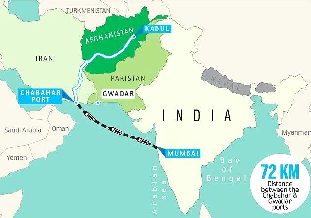
Why is Chabahar Port Important for India?
- About:
- Chahabar is Iran's oceanic port nearest to India. It is situated in Sistan and Baluchistan Province, on the Makran coast. It lies in the Gulf of Oman.
- Chahabar Port project has two main ports called the Shahid Kalantari Port and the Shahid Beheshti Port.
- Iran had offered India the project of developing the Shahid Beheshti port which was well received by India.
- Progress and Updates Regarding the Chabahar Port Deal:
- India signed a memorandum of understanding (MoU) for the development of the Chabahar port in May 2015.
- In May 2016, India, Iran, and Afghanistan signed a trilateral agreement to establish the International Transport and Transit Corridor, also known as the Chabahar Agreement.
- This agreement aimed to improve transportation and trade connectivity between the three countries by utilising the port of Chabahar in Iran as a key transit point.
- However, the finalisation of the long-term agreement has been delayed by several factors including differences on some clauses in the pact.
- The point of disagreement was the location of arbitration for disputes. India preferred a neutral country, while Iran insisted on its own courts or a favourable one.
- Now, both parties have agreed on a compromise that satisfies their respective interests. The contract stipulates that any disagreements should be settled through open communication and cooperation between the leaders of both countries.
- This fresh long-term agreement aims to supersede the initial contract, spanning a duration of 10 years with automatic renewal provisions.
- Significance of Chabahar Port:
- Alternative Trade Route: Historically, India's access to Afghanistan and Central Asia has been largely dependent on transit routes through Pakistan.
- Chabahar Port offers an alternative route that bypasses Pakistan, reducing India's reliance on its neighbour for trade with Afghanistan and beyond.
- Also, Chabahar port will boost India's access to Iran, the key gateway to the International North-South Transport Corridor(INSTC) that has sea, rail and road routes between India, Iran, Russia, Central Asia and Europe.
- Economic Benefits: Chabahar will play a crucial role in India's efforts to enhance connections with the resource-rich Central Asian countries and Afghanistan.
- It will allow India to diversify its trading routes and gain enhanced access to the markets of Russia, Eurasia and Europe, apart from Iran and Afghanistan.
- Cargo movement through INSTC route is expected to save 30% in cost and 40% in transportation time, ensuring quick turnaround at a competitive cost.
- Central Asian nations, rich in resources but without direct access to the sea like Kazakhstan and Uzbekistan, have shown interest in utilising Chabahar to connect to the Indian Ocean Region and tap into the Indian market.
- It will allow India to diversify its trading routes and gain enhanced access to the markets of Russia, Eurasia and Europe, apart from Iran and Afghanistan.
- Humanitarian Assistance: Chabahar Port can serve as a crucial entry point for humanitarian assistance and reconstruction efforts in Afghanistan.
- Port has played a crucial role in supplying humanitarian aid, notably during the Covid-19 pandemic.
- 2.5 million tonnes of wheat and 2,000 tonnes of pulses have been trans-shipped from India to Afghanistan via Chabahar port.
- In 2021, India provided 40,000 liters of the eco-friendly pesticide malathion to Iran through the port to combat locust attacks.
- Strategic Influence and Regional Stability: By developing and operating Chabahar Port, India can enhance its strategic influence in the Indian Ocean region, thus strengthening India's geopolitical position.
- The Chabahar port will act as a counter to China’s development of the Gwadar port in Pakistan.
- Also, India can effectively respond to cases of sea piracy and serve as a first line of defense in the Arabian Sea, due to the docking facilities available at Chabahar.
- Alternative Trade Route: Historically, India's access to Afghanistan and Central Asia has been largely dependent on transit routes through Pakistan.
What are the Challenges in Realising Potential of Chabahar Port?
- Concern of US with Iran:
- The United States warned India of "potential risk of sanctions" after it signed a long-term main contract for the development of Chabahar Port of Iran.
- The US has imposed restrictions on activities with Iran under various legal authorities since 1979, following the seizure of the US Embassy in Tehran.
- Earlier in 2018, the US granted India an exemption from specific sanctions in order to support the advancement of the Chabahar port and the building of a railway link to connect it with Afghanistan.
- The United States warned India of "potential risk of sanctions" after it signed a long-term main contract for the development of Chabahar Port of Iran.
- Houthi-Red Sea Crisis:
- The Houthi rebels can disrupt sea lanes of communication, which will affect traffic at the Chabahar port as well.
- Security Concerns, Regional Tensions:
- The US exit from Afghanistan and the return of the Taliban there, have created an unstable situation there which has negatively influenced trade relations with India.
- Unstable relations between Iran and some of its neighbours, such as Israel, as well as the unstable political situations in neighbouring countries like Afghanistan and Pakistan, are also taking a toll on India’s economic interests at Chabahar Port.
- Competition from Similar Projects:
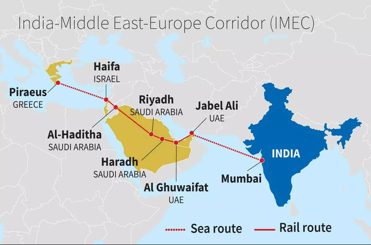
- Opposition or competition from several transport routes, like the India-Middle East-Europe Economic Corridor (IMEC) poses a challenge to Chahbahar as both of these corridors link Asia with Eastern Europe.
- Competition from China:
- Chinese investment in Chabahar can undermine India's interest in Iran due to strong competitors like China.
- Infrastructure development:
- The Chabahar Project seeks to improve infrastructure such as ports, roads, and railways, requiring significant investment, time, and expertise. Any delays or inefficiencies could impede its progress.
What is the Status of Economic Ties Between India and Iran?
- India-Iran bilateral trade during FY 2022-23 was USD 2.33 billion, showing a year-on-year growth of 21.76%.
- India's export to Iran was USD 1.66 billion and India's import from Iran was USD 672.12 million.
- Total trade decreased by 23.32% compared to the corresponding figure of the previous year.
- India mainly exported agricultural goods and livestock products to Iran, including meat, milk products, onions, garlic, and canned vegetables.
- Imports from Iran included methyl alcohol, petroleum bitumen, liquified butanes, apples, liquified propane, dates, and almonds.
- The FDI inflows from Iran to India were recorded at just USD 1 million from April 2000 to December 2023.
- India currently does not import Iranian oil as Tehran is under sanctions from the United States (US).
|
Drishti Mains Question: How INSTC and Chabahar Port will complement each other for optimising Indian connectivity with Russia and Eurasia? |
UPSC Civil Services Examination, Previous Year Question (PYQ)
Prelims
Q. What is the importance of developing Chabahar Port by India? (2017)
(a) India’s trade with African countries will enormously increase.
(b) India’s relations with oil-producing Arab countries will be strengthened.
(c) India will not depend on Pakistan for access to Afghanistan and Central Asia.
(d) Pakistan will facilitate and protect the installation of a gas pipeline between Iraq and India.
Ans: (c)
Mains
Q. In what ways would the ongoing U.S-Iran Nuclear Pact Controversy affect the national interest of India? How should India respond to this situation? (2018)
Q. The question of India’s Energy Security constitutes the most important part of India’s economic progress. Analyse India’s energy policy cooperation with West Asian countries. (2017)
Important Facts For Prelims
Pine Needle Power Projects
Why in News?
Uttarakhand's innovative pine needle power projects, aimed at mitigating forest fires and generating electricity, have fallen short of expectations. Despite the vast potential, technological and practical challenges have hindered their success.
What are Pine Needle Power Projects?
- Pine Needle Power Projects: In 2021, the Uttarakhand State government under bio-energy projects announced a scheme to establish power projects that would use pine needles as fuel to generate electricity.
- The original plan was to establish multiple units ranging from 10kW to 250 kW across the State in three phases (worth about 150 MW).
- Though the government expected 58 units to be set up, only six units of 250 kW (totally worth 750 kW) have been established.
- Agency Involved: Uttarakhand Renewable Energy Development Agency (UREDA).
- Potential of Pine Needles as a Resource: 16.36% of Uttarakhand's forest area is covered by chir pine (Pinus roxburghii) forests. An estimated 15 lakh tonnes of pine needles are generated annually in the state.
- If 40% of this, coupled with agricultural residue, could be utilised, it could significantly aid the state's power requirements and provide employment.
- Ecological Impact: Chir pine as an exotic Species prevents the regeneration of localised species.
- Using pine needles as fuel is more efficient and less polluting than using them as firewood or letting them burn away.
Renewable Energy from Pine Needles
- Pine needles in India's sub-Himalayan belt pose a fire hazard, yet they also offer the opportunity to be converted into renewable energy sources like bio-oil, briquettes, or biochar.
- Bio-oil can be used as fuel for engines or furnace oil, while briquettes can be used in brick kilns or boilers for electricity generation.
- Researchers from India's Central Institute of Agricultural Engineering found that the flammability of pine needles makes them a potentially abundant renewable energy source.
- They can be compacted into high calorific value briquettes or converted into bio-oil through pyrolysis.
- The bio-oil has a calorific value of 28.52 megajoules per kilogram and can be used in blended fuels for engines or as furnace oil. This makes it a viable alternative to diesel.
Why have Pine Needle Projects Been Unsuccessful?
- Technological Limitations: According to UREDA, the appropriate technology to sustainably use pine needles for electricity generation does not labour yet.
- Operational Difficulties: Collecting pine needles is challenging due to the steep forest slopes, vulnerability to animal attacks, and insufficient labour at remunerative rates.
- Additionally, the moisture content of the pine needles causes lower efficiency and high maintenance for the gasification system.
- Only a minuscule proportion of available pine needles is currently being collected.
Key Facts about Chir Pine
- Family Name: Pinaceae | Botanical Name: Pinus roxburghii.
- Geographic Origin: India | Ecozone Origin: Indomalaya.
- Natural History: It is one of the most important conifers in the Himalayan region which moulds the life of various ethnic and other communities of the region.
- It is named after William Roxburgh, a Scottish botanist known as the founding father of Indian botany.
- Vegetation Type: The Chir Pine is well-adapted to the Montane Temperate Forests of the Himalayas.
- The dense canopy of Chir Pine trees limits the growth of other plants underneath. However, some shrub species like Rubus ellipticus, Fragaria vesca, Myrica esculenta, etc can survive in these pine forests.
- Geographical Extent: Distributed across the Himalayan mountains, including Bhutan, India (J&K, Punjab, Himachal Pradesh, Uttarakhand), Nepal, Pakistan, Sikkim, Afghanistan, and southern Tibet.
- Characteristics:
- Coniferous tree-producing pine cones with gymnosperm (naked seeds).
- Dark-brown, thick deeply longitudinal fissured bark.
- Leaves grouped three per bundle, slender, flexible, flabellate-triangular in cross-section.
- Growing Conditions:
- Hardy, drought and high-temperature resistant.
- Requires full sun exposure.
- Young trees need weekly watering; mature trees need monthly watering.
- Suitable Locations: Better suited for spacious areas due to its massive root system.
- IUCN Red List Status: Least Concern
UPSC Civil Services Examination, Previous Year Questions (PYQs)
Prelims:
Q. If you travel through the Himalayas, you are likely to see which of the following plants naturally growing there? (2014)
- Oak
- Rhododendron
- Sandalwood
Select the correct answer using the code given below:
(a) 1 and 2 only
(b) 3 only
(c) 1 and 3 only
(d) 1, 2 and 3
Ans: (a)
Important Facts For Prelims
Tea Board of India
Why in News?
Recently, a tea growers and manufacturers association reported that tea production in Assam and West Bengal may decrease by 50% in the coming months due to inadequate and uneven rainfall.
- Data from the Tea Board of India shows a projected 40% decrease in Assam and 23% decrease in West Bengal production until March 2024.
What is the Tea Board of India?
- About:
- The Tea Board India was established in 1903 through the Indian Tea Cess Bill, which imposed a tax on tea exports to fund the promotion of Indian tea domestically and internationally.
- The present Tea Board was set up under section 4 of the Tea Act 1953 and was constituted on 1st April 1954.
- It has succeeded the Central Tea Board and the Indian Tea Licencing Committee which functioned respectively under the Central Tea Board Act, 1949 and the Indian Tea Control Act, 1938 which were repealed.
- Organisation of the Board:
- The present Tea Board is functioning as a statutory body of the Central Government under the Ministry of Commerce.
- The Board is composed of 31 members (including the Chairman) drawn from Members of Parliament, tea producers, tea traders, tea brokers, consumers, and representatives of Governments from the principal tea-producing states, and trade unions.
- The Board is reconstituted every three years.
- Functions:
- Rendering financial and technical assistance for the cultivation, manufacture and marketing of tea.
- Aiding Research and Development activities for augmentation of tea production and improvement of tea quality.
- With Head Office located in Kolkata, West Bengal it has twenty-three offices which include Zonal, Regional and Sub-Regional Offices.
Key Facts About Tea:
- Growth Conditions:
- Climate: Tea is a tropical and sub-tropical plant and grows well in hot and humid climates.
- Temperature: The ideal temperature for its growth is 20°-30°C and temperatures above 35°C and below 10°C are harmful for the bush.
- Rainfall: It requires 150-300 cm annual rainfall which should be well distributed throughout the year.
- Soil: The most suitable soil for tea cultivation is slightly acidic soil (without calcium) with porous sub-soil which permits a free percolation of water.
- Tea is the second most consumed beverage in the world after water.
- India was the second-largest producer of tea after China, and the largest consumer of said beverage, using nearly 30% of the world’s tea output.
- Benefits:
- Antioxidants in tea help prevent oxidative damage to the body and act as reactive oxygen species (ROS) to repair damages caused by free radicals. They also enhance immune defense, lowering the risk of cancer and infection.
- Concerns:
- However, recent ICMR guidelines advise against excessive consumption of caffeine in tea and coffee as it can stimulate the body's central nervous system and lead to physiological dependence.
- The report stated that beverages like tea can bind dietary iron and make it unavailable, due to tannins in caffeinated beverages hindering iron absorption in the body.
- This can lead to iron deficiency and conditions like anaemia.
- However, recent ICMR guidelines advise against excessive consumption of caffeine in tea and coffee as it can stimulate the body's central nervous system and lead to physiological dependence.

UPSC Civil Services Examination, Previous Year Questions (PYQ)
Prelims
Q1. With reference to the "Tea Board" in India, consider the following statements: (2022)
- The Tea Board is a statutory body.
- It is a regulatory body attached to the Ministry of Agriculture and Farmers Welfare.
- The Tea Board's Head Office is situated in Bengaluru.
- The Board has overseas offices at Dubai and Moscow.
Which of the statements given above are correct?
(a) 1 and 3
(b) 2 and 4
(c) 3 and 4
(d) 1 and 4
Ans: (d)
Q2. Consider the following States: (2022)
- Andhra Pradesh
- Kerala
- Himachal Pradesh
- Tripura
How many of the above are generally known as tea-producing States?
(a) Only one State
(b) Only two States
(c) Only three States
(d) All four States
Ans: (c)
Mains
Q. Whereas the British planters had developed tea gardens all along the Shivaliks and Lesser Himalayas from Assam to Himachal Pradesh, in effect they did not succeed beyond the Darjeeling area. Explain. (2014)
Rapid Fire
Tartessos Civilization
Archaeologists of the Spanish National Research Council unearthed five stone faces in Guarena, Spain, dating back to the extinct Tartessos Civilization.
- Tartessos Civilization existed around 3000 years ago (9th-6th centuries BCE) in Huelva and Cadiz. This region was bordered by a large gulf connected to the Mediterranean Sea.
- Tartessos was a blend of Iberian and Phoenician influences, known for trade, metalwork, and maritime skills, thriving until its decline, likely triggered by economic shifts, environmental challenges, and conflicts with neighbouring cultures.
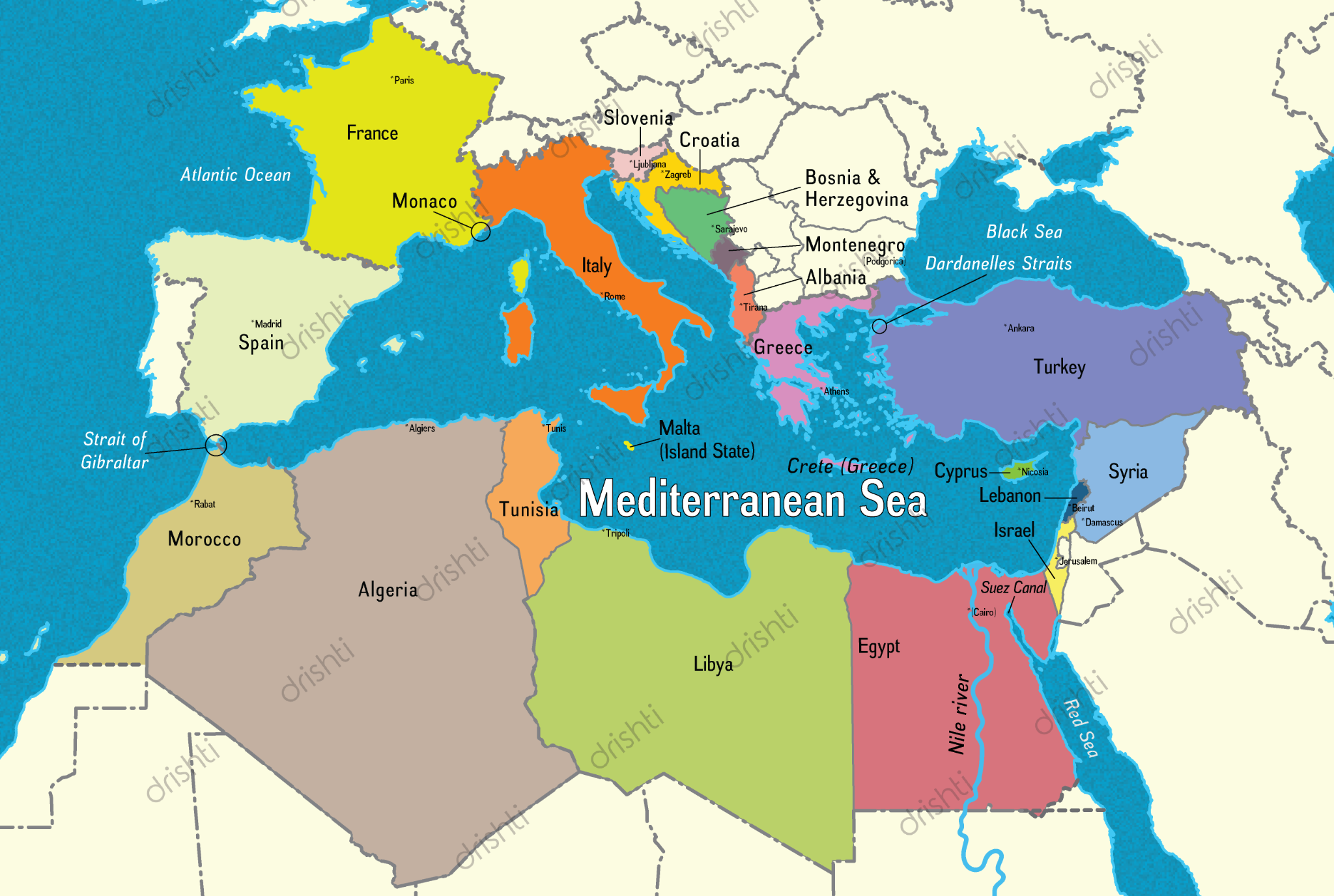
Read More: Mediterranean Sea
Rapid Fire
Project ISHAN
India has started the process of consolidating its 4 airspace regions into a single entity spanning the entire nation under Initiative Indian Single Sky Harmonized Air Traffic Management (ISHAN).
- Currently, Indian airspace is divided into 4 Flight Information Regions (FIRs) in Delhi, Mumbai, Kolkata, and Chennai, each managed separately.
- Under ISHAN, these will be consolidated into one continuous airspace centred in Nagpur.
- It seeks to streamline and enhance air traffic management across India.
- The Airports Authority of India (AAI), invited expressions of interest (EoI) for the preparation of a detailed project report.
- AAI was constituted by an Act of Parliament and came into being on 1st April 1995 by merging erstwhile National Airports Authority and International Airports Authority of India.
- It works under the Directorate General of Civil Aviation, Ministry of Civil Aviation, Government of India.
Read More: India's Aviation Industry.
Rapid Fire
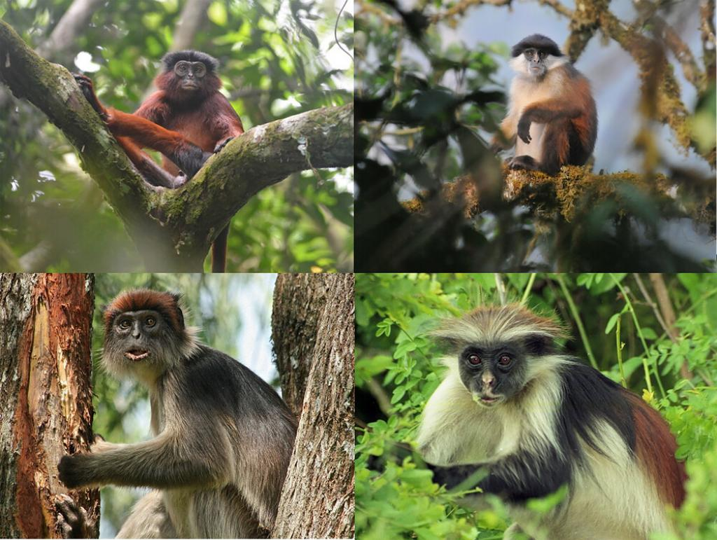
Red Colobus
A recent study suggests that Red Colobus Monkeys, a rare and endangered population of monkeys found in various regions of Africa are facing threats to their survival and are at risk of becoming extinct.
- These monkeys act as "indicator species," meaning their presence and well-being reflect the overall health of the forest ecosystem.
- Colobines are primarily leaf-eaters. They also play a vital role in seed dispersal, contributing to the regeneration of diverse plant life.
- Their unique digestive system allows them to consume and disperse seeds, ensuring the continuation of various plant species.
- Across Africa, there are 17 red colobus species (18 if subspecies are counted), spanning from Senegal to the Zanzibar Archipelago.
- 14 of them are classified as Endangered or Critically Endangered on the IUCN Red List of Threatened Species.
Read More: IUCN Red List Update 2023
Rapid Fire
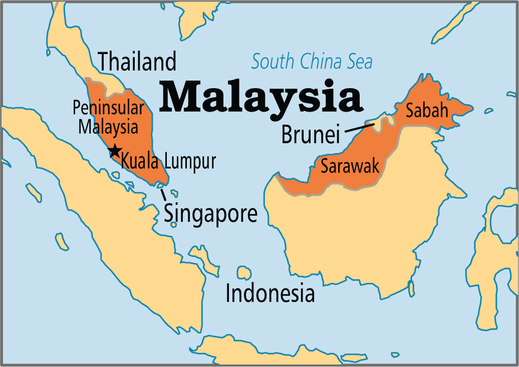
Visit of Indian Naval Ships to Malaysia
Recently, Indian Naval ships, INS Delhi and INS Shakti, visited Kota Kinabalu, Malaysia as part of the Indian Navy's Operational Deployment. The visit aims to strengthen the friendship and cooperation between India and Malaysia through a series of engagements and activities.
- The Indian Navy ships will participate in a Maritime Partnership Exercise (MPX)/ PASSEX at sea with ships of the Royal Malaysian Navy to enhance interoperability between the two Navies.
- INS Delhi is the first indigenously designed and built Project-15 class guided missile destroyer, while INS Shakti is a Fleet Support Ship, both part of the Indian Navy's Eastern Fleet.
- India-Malaysia Relations:
- Surrounded by busy sea lines of communications such as the Strait of Malacca and the South China Sea, Malaysia is a key pillar of India’s Act East policy and critical to India’s maritime connectivity strategies.
- India and Malaysia have signed the Comprehensive Economic Cooperation Agreement (CECA). CECA is a kind of Free Trade Agreement (FTA).
- Joint defence exercises between India and Malaysia:
- Army: Exercise Harimau Shakti
- Airforce: Exercise Udarashakti
- Navy: Exercise Samudra Laksamana
Read More: India-Malaysia Defence Cooperation
Rapid Fire
Quotas for PwDs in All Trains
The Ministry of Railways has approved quotas for People with Disabilities (PwDs) in all trains, irrespective of whether any concessional fare facility is available or not.
- PwD quota will be earmarked in all reserved Express/Mail trains.
- To avoid misuse of the provision, Verified Indian Railways Unique Identity Cards will be issued to eligible by Indian Railways, and tickets under this quota will be booked using this Card only.
- The Centre for Railway Information Systems (CRIS) was instructed to update its reservation software to verify Unique Identity Cards on all trains, including those without concessional fares.
- CRIS, an Autonomous Organization under the Ministry of Railways, is tasked with developing and overseeing essential IT applications for the Indian Railways.
- The Centre for Railway Information Systems (CRIS) was instructed to update its reservation software to verify Unique Identity Cards on all trains, including those without concessional fares.
- Initiatives undertaken in India to empower persons with disabilities include:
- Rights of Persons with Disabilities (RPwDs) Act, 2016
- Unique Disability Identification Portal
- Accessible India Campaign
- DeenDayal Disabled Rehabilitation Scheme
- Assistance to Disabled Persons for Purchase/fitting of Aids and Appliances, National Fellowship for Students with Disabilities
- Divya Kala Mela 2023
Read More: Vande Bharat Trains , People with Disabilities (PwDs)


