International Relations
40th Charter Day of SAARC
For Prelims: South Asian Association for Regional Cooperation, South Asian Free Trade Area, National Knowledge Network , European Union (EU), Association of Southeast Asian Nations, Belt and Road Initiative , BIMSTEC
For Mains: South Asian regionalism, India's role and contributions to SAARC, Economic and Political cooperation.
Why in News?
On 8th December 2024, the South Asian Association for Regional Cooperation (SAARC) marked its 40th Charter Day. This day is commemorated annually to honor the establishment of SAARC.
What is the South Asian Association for Regional Cooperation?
- Origins of SAARC: Regional cooperation in South Asia was first discussed at the Asian Relations Conference (1947), the Baguio Conference (1950), and the Colombo Powers Conference (1954).
- The SAARC concept took shape in 1980 when Bangladesh's President Ziaur Rahman proposed regional cooperation to promote peace and stability.
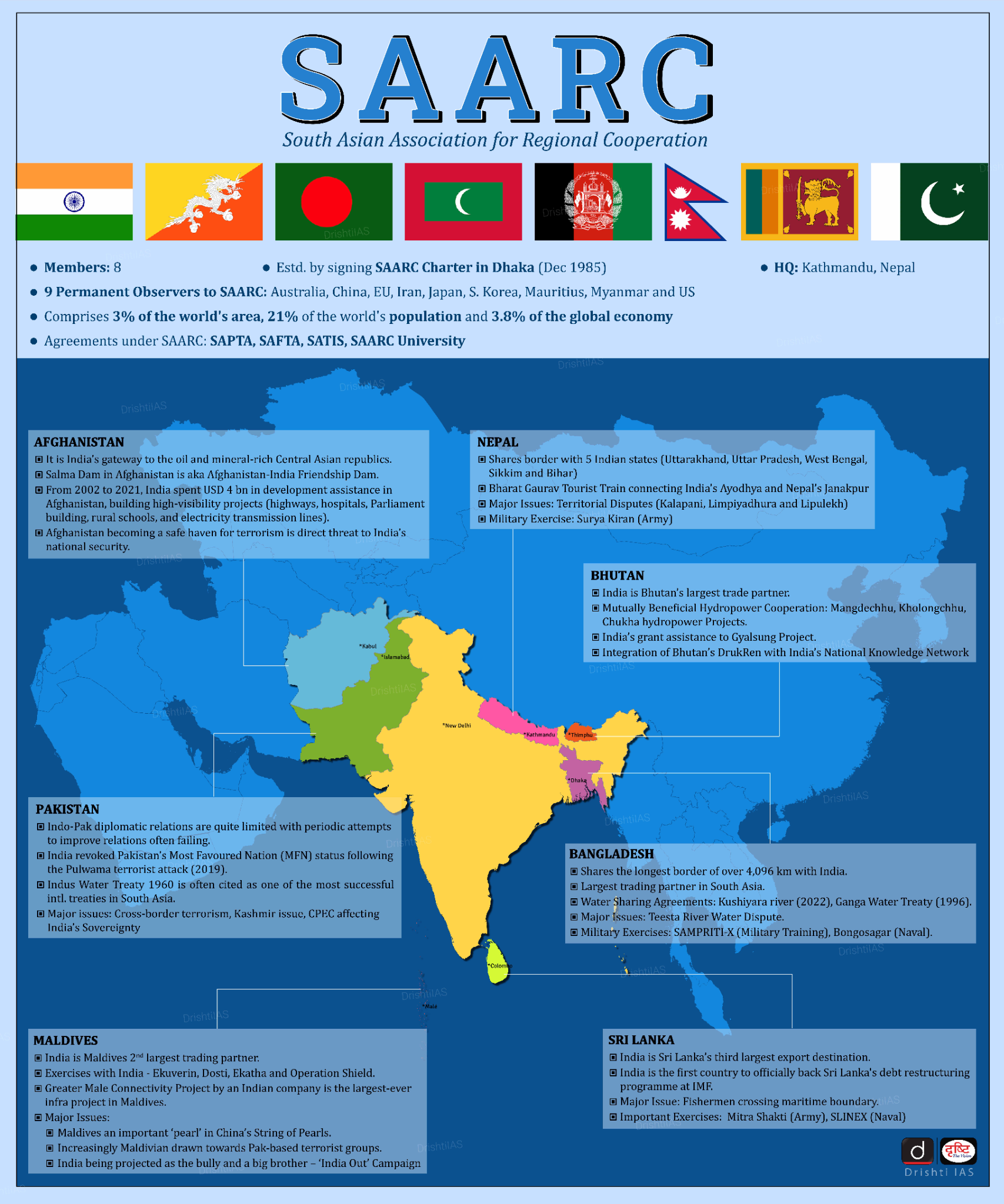
- SAARC was officially established on 8th December 1985, in Dhaka, Bangladesh, with 7 founding members: Bangladesh, Bhutan, India, Maldives, Nepal, Pakistan, and Sri Lanka.
- Afghanistan joined as the 8th member in 2007.
- Objectives:
- Promote welfare and improve quality of life in South Asia.
- Accelerate economic growth, social progress, and cultural development.
- Strengthen self-reliance and mutual trust among member states.
- Enhance collaboration in economic, social, cultural, technical, and scientific fields.
- Cooperate with other developing countries and international organizations.
- Key Principles: Sovereign equality, territorial integrity, non-interference, and consensus-based decision-making.
- Significance of SAARC: SAARC comprises 3% of the world's land area, 21% of the world's population and 5.21% (USD 4.47 trillion) of the global economy, as of 2021.
- Scope of Cooperation: SAARC's agenda includes the South Asian Free Trade Area (SAFTA), established in 2004 and effective from 2006, aimed at reducing tariffs and promoting free trade in South Asia.
- The SAARC Agreement on Trade in Services (SATIS) came into force in 2012, to enhance intra-regional investments and liberalize trade in services.
What is the Relevance of SAARC in Today’s Context?
- Platform for Dialogue: Despite its dysfunction, SAARC remains the one of the few platforms where South Asian countries, including India and Pakistan, can engage in dialogue.
- Periodic summits provide opportunities to address pressing regional issues, such as climate change and poverty, even if no concrete outcomes emerge.
- Shared Regional Solutions: Issues like cross-border terrorism, and pandemics demand a collective regional response.
- SAARC has previously coordinated initiatives, such as the establishment of a Covid-19 Emergency Fund, highlighting its utility during crises.
- Potential for Economic Integration: With a combined GDP of over USD 4 trillion and a population of nearly 1.8 billion, South Asia has significant untapped potential.
- SAARC’s frameworks, such as SAFTA and the SAARC Agreement on Trade in Services, can still be revitalized to enhance trade and economic cooperation.
- Avoiding Overdependence on External Frameworks: Ignoring SAARC may force member nations to rely heavily on external platforms like ASEAN or China-led initiatives such as the BRI.
- SAARC provides a means for South Asia to control its developmental trajectory.
What is India’s Contribution to SAARC?
- SAARC Summits: India has hosted three out of the eighteen SAARC Summits: the 2nd summit in Bengaluru (1986), the 8th summit in New Delhi (1995), and the 14th summit in New Delhi (2007).
- Technological Cooperation: India has extended its National Knowledge Network (NKN) to countries such as Sri Lanka, Bangladesh, and Bhutan, fostering educational and technological exchange.
- Additionally, India launched the South Asian Satellite (SAS) in 2017, providing satellite-based services to SAARC countries.
- Currency Swap Arrangement: In 2019, India approved the incorporation of a ‘Standby Swap’ in the Currency Swap Arrangement for SAARC members, amounting to USD 400 million, aimed at enhancing financial cooperation.
- Disaster Management: India hosts the Interim Unit of the SAARC Disaster Management Center in Gujarat.
- This center provides policy advice, technical support, and training for disaster risk management across SAARC countries.
- South Asian University (SAU): India is home to the South Asian University, established through an Inter-Governmental Agreement at the 14th SAARC.
- It provides world-class education and research opportunities for students and scholars from SAARC nations.
Role India Can Play in Strengthening SAARC
- Leadership Role: As the largest economy, India constitutes over 70% of the area and population among the SAARC nations and is strategically connected to almost all the member nations.
- Initiatives like the SAARC satellite and support for infrastructure development underscore India's commitment.
- Proposed Measures: India must continue offering unilateral concessions, such as duty-free access for least developed SAARC nations.
- Smaller nations should reciprocate by leveraging India’s growth for their own development rather than perceiving it as a threat.
- Strengthen regional connectivity projects like the BBIN Motor Vehicle Agreement and integrate them with global value chains.
- It is essential for India to counter China's growing influence in South Asia, while managing the "Big Brother" perception among smaller neighbors.
- Utilizing platforms like QUAD and Indo-Pacific partnerships can help counterbalance external pressures and ensure regional cooperation.
- India also can utilize BIMSTEC to engage with South and Southeast Asian nations, bypassing Pakistan.
- Promote People-to-People contact through Scholarships, cultural exchanges, and tourism-focused initiatives.
What are the Key Challenges Facing SAARC?
- Political Tensions and Bilateral Conflicts: India and Pakistan dominate SAARC in terms of Gross Domestic Product (GDP) and population, but their strained relations, including issues like terrorism and territorial disputes, have hindered cooperation.
- Pakistan's refusal to address cross-border terrorism led to India boycotting the 19th SAARC Summit in 2016, resulting in its postponement.
- The 18th SAARC summit was held in Kathmandu in 2014, and its outcome was a 36-point Kathmandu declaration.
- Many member states, including Bangladesh, Afghanistan, and Pakistan, face political instability and governance issues that disrupt long-term regional planning.
- Low Economic Integration: Intra-regional trade in SAARC is a mere 5% of its total trade, compared to 65% in the European Union (EU) and 26% in Association of Southeast Asian Nations.
- Limited implementation of the SAFTA and lack of product diversification have stymied economic growth.
- Asymmetric Development: India's dominance often leads to the "Big Brother Syndrome," causing mistrust among smaller nations.
- Smaller member states often perceive India as overly dominant, leading to resistance against Indian initiatives. This perception discourages collective action and fosters reliance on external powers like China.
- Nepal, Bhutan, and Maldives struggle with infrastructure deficits and limited resources.
- Institutional Weaknesses: SAARC’s charter requires unanimous agreement for decisions, enabling any member to veto progress on critical issues.
- Pakistan has frequently used this mechanism to block agreements like the SAARC Motor Vehicles and Railways pacts.
- Observers like China, the EU, and the US lack clarity on their roles, limiting external support.
- The exclusion of contentious bilateral matters limits SAARC’s ability to address underlying causes of regional tensions. This provision undermines the organization's relevance in resolving disputes.
- External Influences:China's growing presence through the Belt and Road Initiative (BRI) and its strategic investments in Sri Lanka, Bangladesh, and Pakistan complicates intra-SAARC dynamics.
- The China-Pakistan Economic Corridor (CPEC) and Hambantota port developments amplify China's influence.
Way Forward
- Promoting Economic Cooperation: Accelerate the operationalization of the SATIS.
- Expand initiatives like the SAARC Development Fund to support regional projects in infrastructure, healthcare, and education.
- Resolving Political Conflicts: Mediation mechanisms within SAARC could help address bilateral tensions. Promote Track-II diplomacy involving academia, business leaders, and civil society.
- Track II diplomacy is an informal, non-governmental approach to resolving conflicts through dialogue and workshops to reduce tension.
- Prioritize issues like disaster management, education, and public health, which are less politically sensitive.
- Leveraging Sub-regional Groupings: Initiatives like BBIN (Bangladesh, Bhutan, India, Nepal) and BIMSTEC (Bay of Bengal Initiative for Multi-Sectoral Technical and Economic Cooperation) can complement SAARC’s objectives and foster trust.
- Combating Non-traditional Security Threats: Strengthen regional cooperation on counter-terrorism, disaster management, and enhance intelligence-sharing frameworks among member nations.
- Reform Institutional Mechanisms: Replace the consensus-based decision-making model with weighted voting to prevent a single country from blocking progress.
- Strengthen the SAARC Secretariat with greater autonomy and financial resources.
- Encouraging Youth Participation: Utilize South Asia’s demographic dividend by fostering student exchanges, scholarships, and youth-centric development programs through the South Asian University and other regional platforms.
Conclusion
SAARC remains a crucial platform for regional cooperation despite challenges like political tensions and low economic integration. India's growing leadership can strengthen the organization’s potential. To realize its full potential, SAARC must focus on enhancing economic cooperation, resolving political conflicts, and fostering sub-regional partnerships.
|
Drishti Mains Question: Discuss the role of SAARC in promoting regional cooperation in South Asia. What challenges hinder its effectiveness in achieving economic integration? |
UPSC Civil Services Examination, Previous Year Questions (PYQs)
Mains:
Q. “Increasing cross-border terrorist attacks in India and growing interference in the internal affairs of several member-states by Pakistan are not conducive for the future of SAARC (South Asian Association for Regional Cooperation).” Explain with suitable examples. (2016)


Geography
Ninetyeast Ridge
For Prelims: Ninetyeast Ridge, Indian Ocean, Natural disasters, Bay of Bengal, Submarine volcanism, Seamounts, Early warning systems, Tectonic Plates
For Mains: Plate Tectonics and Hotspot , Tectonic Plate Movements and Natural Disasters
Why in News?
A recent Nature Communications study reveals that the Ninetyeast Ridge, the Earth's longest straight underwater mountain chain, was formed by a moving hotspot, challenging the earlier belief that it originated from a stationary hotspot.
- This study provides new insights into Earth’s tectonic processes, and age estimates of Ninetyeast Ridge.
What are the Key Findings of the Study?
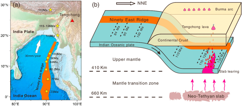
- Formation by a Moving Hotspot: The Ninetyeast Ridge, a 5,000 km-long underwater mountain chain in the Indian Ocean, was formed by the Kerguelen hotspot(volcanic hotspot located at the Kerguelen Plateau in the Southern Indian Ocean), which moved several hundred kilometers within the Earth's mantle, rather than being formed by a stationary hotspot as previously believed.
- The study is the first documented case of a moving hotspot in the Indian Ocean, contributing new evidence to the theory of hotspot movement, which has been difficult to prove.
- Age Estimates: High-precision dating of mineral samples from the ridge shows that the Ninetyeast Ridge formed between 83 and 43 million years ago.
- Impact on Tectonic Models: The study provides a more accurate reconstruction of Earth's tectonic history and highlights the importance of understanding mantle dynamics and hotspot movement to better predict natural disasters.
What is the Ninetyeast Ridge?
- About: The Ninetyeast Ridge is a linear aseismic ridge. It is named for its near-parallel alignment with the 90th meridian east.
- This underwater mountain range stretches approximately 5,000 kilometers from the Bay of Bengal in the north to the Southeast Indian Ridge (SEIR) in the south.
- The northern segment of the Ninetyeast Ridge has massive volcanoes, the southern part is tall and continuous, and the middle section includes small seamounts and straight segments.
- It divides the Indian Ocean into the West Indian Ocean and the eastern Indian Ocean.
- Formation of the Ninety East Ridge: The most widely accepted theory is the hotspot theory, with some geologists attributing the ridge's formation to the Kerguelen hotspot.
- As the Indo-Australian plate moved north, it passed over this hotspot, forming the ridge.
- The formation process ceased due to a reorganization in the tectonic plate boundaries, and further research ongoing to confirm this theory.
- Composition: Primarily made of Ocean Island Tholeiites (OIT), a type of sub-alkaline basalt rock.
- Rocks in the southern part of Ninetyeast Ridge are younger (43.2 million years) compared to the northern part (81.8 million years).
What is the Geological Significance of a Hotspot?
- About: A hotspot is an area where hot plumes of molten rock (magma) rise from deep within Earth's mantle. These plumes can form volcanoes on the Earth's crust as they reach the surface.
- Unlike most volcanic activity, hotspot volcanism is not driven by tectonic plate boundaries but rather by stationary plumes beneath moving plates.
- Hotspot Volcanism and Submarine Volcanism: Hotspot volcanism is different from submarine volcanism. Submarine volcanism happens where tectonic plates meet and move(plate boundaries).
- In contrast, Hotspot volcanism occurs within lithospheric plates, rather than at plate boundaries where convergence or divergence happens.
- Hotspot Track: As tectonic plates move over a hotspot, active volcanoes form above the plume, while older ones are carried away, creating a chain of islands or seamounts.
- A hotspot track is a linear chain of volcanoes formed by a stationary plume beneath a moving tectonic plate. The youngest and most active volcano is above the plume, with older volcanoes further away in the direction of plate movement.
- The Hawaiian Islands and their seamount chain are a prime example of a hotspot track, with the Island of Hawaii being the youngest and most active in the chain.
- Dynamic Nature of Hotspots: There is ongoing debate about the irregular volcanism patterns observed in island chains like the Cook-Australs, Marshalls, Gilberts, and Line Islands. Some theories suggest that hotspots, traditionally thought to be stationary, may actually be dynamic.
- The debate continues as scientists gather more data to understand the complex processes driving volcanism in these regions.
How Do Hotspots Impact Tectonic Plates and Natural Disasters?
- Hotspot Influence on Tectonic Plates:
- Volcanic Chains and Plate Movement: The sequence of these islands, from youngest to oldest, provides evidence for plate motion.
- The distance between these islands also allows scientists to estimate plate speed.
- Hotspots, linked to geothermal features like geysers, offer insights into tectonic plate movements and interactions.
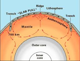
- Mantle plumes drive plate tectonics by supplying heat and movement, crucial for the large-scale motion of Earth's tectonic plates.
- Rifting and Continental Breakup: Hotspots can contribute to continental rifting, where plates pull apart.
- A mantle plume beneath a continent can weaken the lithosphere, causing it to break apart.
- The East African Rift is an example of a continent being split.
- A mantle plume beneath a continent can weaken the lithosphere, causing it to break apart.
- Volcanic Chains and Plate Movement: The sequence of these islands, from youngest to oldest, provides evidence for plate motion.
- Mantle and Hotspot Influence of Natural Disasters:
- Earthquakes: Mantle plumes and the movement of tectonic plates can lead to earthquakes. Understanding the dynamics of these movements helps in identifying regions at risk of seismic activity.
- This knowledge is essential for designing and implementing early warning systems.
- Tsunamis: Earthquakes and volcanic eruptions under the ocean can trigger tsunamis. By studying the patterns of mantle dynamics and hotspot activity, scientists can better predict the likelihood of such events and issue warnings to coastal areas.
- Earthquakes: Mantle plumes and the movement of tectonic plates can lead to earthquakes. Understanding the dynamics of these movements helps in identifying regions at risk of seismic activity.
|
Drishti Mains Question: Examine the role of hotspots in plate tectonics and their impact on the formation of volcanic islands. |
UPSC Civil Services Examination, Previous Year Question (PYQ)
Prelims
Q. Consider the following: (2013)
- Electromagnetic radiation
- Geothermal energy
- Gravitational force
- Plate movements
- Rotation of the earth
- Revolution of the earth
Which of the above are responsible for bringing dynamic changes on the surface of the earth?
(a) 1, 2, 3 and 4 only
(b) 1, 3, 5 and 6 only
(c) 2, 4, 5 and 6 only
(d) 1, 2, 3, 4, 5 and 6
Ans: (d)
Mains:
Q. Discuss about the vulnerability of India to earthquake related hazards. Give examples including the salient features of major disasters caused by earthquakes in different parts of India during the last three decades. (2021)
Q. Why are the world’s fold mountain systems located along the margins of continents? Bring out the association between the global distribution of fold mountains and earthquakes and volcanoes. (2014)


Indian Economy
Rise in Forex Reserves
For Prelims: Foreign Exchange, Trade Deficit, Current Account Deficit, Foreign Direct Investment, Foreign Portfolio Investors, External Commercial Borrowings, Tapering, Taper Tantrum, Foreign Currency Non-Resident Bank, Secured Overnight Rupee Rate, Treasury Bills Repurchase Agreement, Framework for Responsible and Ethical Enablement of AI, MuleHunter.AI.
For Mains: India’s foreign exchange reserve and RBI’s initiative to strengthen the banking system.
Why in News?
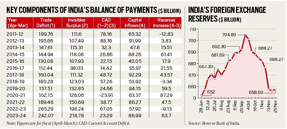
India's foreign exchange rose to USD 658.09 billion in November 2024 after eight weeks of decline, following the peak of USD 704.89 billion in September 2024.
- In another development, RBI has planned several initiatives for a robust banking system.
What are Key Developments in India’s Forex Reserves?
- Forex Reserves Movement: The movement in forex reserves is intrinsically linked to India's merchandise trade deficit and service exports.
- Merchandise Trade Deficit: India has historically run a merchandise trade deficit, with imports (USD 683.55 billion in 2023-24) exceeding exports (USD 441.48 billion), resulting in a trade deficit of USD 242.07 billion in 2023-24.
- Services and Remittances: Software service exports increased from USD 60.96 billion in 2011-12 to USD 142.07 billion in 2023-24, boosted by global digitization post-COVID.
- Private remittances rose from USD 63.47 billion in 2011-12 to USD 106.63 billion in 2023-24.
- Current and Capital Account Position: The Current Account Deficit (CAD) narrowed from USD 78.16 billion in 2011-12 to USD 23.29 billion in 2023-24, despite a consistent merchandise trade deficit.
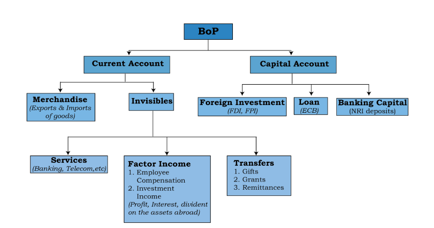
- Capital flows include Foreign Direct Investment (FDIs), Foreign Portfolio Investors (FPIs) , external commercial borrowings (ECBs), and NRI deposits.
- Out of these, FDI flows are considered more stable while the other three sources are either fickle (FPI) or short-term (ECB and NRI deposits) and prone to sudden outflows and withdrawals.
- FDI and FPI Trends: FDI flows into India have dropped from USD 56.01 billion in 2019-20 to USD 26.47 billion in 2023-24.
- Net FPI flows stand at a record USD 44.08 billion in 2023-24.
- Future Outlook: Despite fluctuating FDI and uncertain geopolitical scenario, the situation isn't too bad.
- In 2011-12 and 2012-13, the US Federal Reserve's reduction of bond purchases (tapering) led to reduced capital flows, causing the rupee to drop and forex reserves to shrink.
Note:
The "invisibles" account, including services and remittances, has consistently shown a surplus, helping offset the merchandise trade deficit.
- Tapering is a term used in finance to describe a reduction of monetary stimulus provided by central authorities to the capital markets. It is the reversal of quantitative easing policies, intended to stimulate economic growth.
- Financial markets may experience a downturn in response to tapering, known as a "taper tantrum."
What are Foreign Exchange Reserves?
- About: Foreign exchange reserves are assets held on reserve by a central bank in foreign currencies.
- It can include banknotes, deposits, bonds, treasury bills, and other government securities.
- Following the 1990-91 economic crisis, C. Rangarajan and Y.V. Reddy committee recommended maintaining forex reserves to cover 12 months of imports.
- Components: India’s Forex Reserve include:
- Foreign Currency Assets (FCA): FCA predominantly composed of major global currencies like the US Dollar, Euro, and Japanese Yen.
- Gold Reserves: Gold has long been valued as a key reserve asset offering both stability and universal acceptance.
- Special Drawing Rights (SDRs): SDRs, created by the International Monetary Fund (IMF), are reserve assets that supplement member countries' official reserves.
- Reserve position with IMF: It is a portion of the required quota of currency each member country must provide to the IMF.
What is the Role of Forex Reserves in Economic Stability?
- Economic Buffer: Reserves help countries manage downturns, stabilize currency, and maintain investor trust.
- Trade Equilibrium: Reserves enable countries to address trade imbalances when imports exceed exports.
- Monetary Strategy: Reserves allow central banks to control currency value, manage inflation, and implement monetary policies.
- Fulfilling External Obligations: Sufficient reserves help countries meet external debt, boosting international credibility.
- Exchange Rate Management: Central banks use reserves to intervene in the foreign exchange market, ensuring competitiveness and reducing volatility.
- Liquidity Provision: Reserves ensure a country can meet financial obligations, like debt and imports, during crises.
What are the RBI’s Recent Initiatives to Create a Robust Banking System?
- FCNR(B) Deposits: In order to attract more capital inflows, the RBI has decided to increase the interest rate ceilings on Foreign Currency Non-Resident Bank (FCNR (B)) account deposits.
- FCNR (B) accounts are foreign currency term deposits that non-resident Indians can open with Indian banks.
- SORR Benchmark: RBI is planning to introduce the Secured Overnight Rupee Rate (SORR) as a new benchmark based on all secured money market transactions, including overnight market repos and TREPS (Treasury Bills Repurchase Agreement).
- It will help develop the interest rate derivatives market and enhance the credibility of interest rate benchmarks in India.
- Collateral-Free Agriculture Loans: The RBI has decided to increase the limit for collateral-free agricultural loans from Rs 1.6 lakh to Rs 2 lakh per borrower.
- Panel on AI: The RBI will set up a committee of experts to recommend a Framework for Responsible and Ethical Enablement of AI (FREE-AI) in the financial sector to ensure ethical use and minimize risks.
- The RBI has developed an AI/ML-based model called MuleHunter.AI to help banks manage and combat mule bank accounts.
Conclusion
India's forex reserves are stabilizing after recent declines, bolstered by strong "invisibles" and managed capital inflows. RBI's strategic initiatives, including the introduction of SORR, increased FCNR(B) interest rates, and enhanced AI solutions, aim to fortify the banking system, ensuring stability and fostering sustainable economic growth.
|
Drishti Mains Question: How can the RBI’s management of forex reserves and introduction of new initiatives bolster the resilience of India’s financial sector? |
UPSC Civil Services Examination, Previous Year Questions (PYQs)
Prelims
Q. If the RBI decides to adopt an expansionist monetary policy, which of the following would it not do?(2020)
- Cut and optimize the Statutory Liquidity Ratio
- Increase the Marginal Standing Facility Rate
- Cut the Bank Rate and Repo Rate
Select the correct answer using the code given below:
(a) 1 and 2 only
(b) 2 only
(c) 1 and 3 only
(d) 1, 2 and 3
Ans: (b)
Q. Which of the following statements is/are correct regarding the Monetary Policy Committee (MPC)?(2017)
- It decides the RBI’s benchmark interest rates.
- It is a 12-member body including the Governor of RBI and is reconstituted every year.
- It functions under the chairmanship of the Union Finance Minister.
Select the correct answer using the code given below:
(a) 1 only
(b) 1 and 2 only
(c) 3 only
(d) 2 and 3 only
Ans: (a)
Mains
Q. The product diversification of financial institutions and insurance companies, resulting in overlapping of products and services strengthens the case for the merger of the two regulatory agencies, namely SEBI and IRDA. Justify. (2013)


Geography
India’s Ancient Water Harvesting System
For Prelims: Sri Krishna Devaraya, Nallamala Hills, Eastern Ghats, Kuruma Tribe, Baoli, Kuhls, Shompen Tribe, Great Nicobar Islands, Dholavira, Lothal, Arthashastra, Satavahanas, Chola Period, Feroze Shah Tughlaq, Jal Jeevan Mission, Jhalara, Ahar Pynes, Zing, Zabo.
For Mains: Different methods of India’s Ancient Water Harvesting System.
Why in News?
Recently, the Cumbum tank in Andhra Pradesh was in the news for its ancient water harvesting system.
- Cumbum tank is a medium irrigation project which is the 2nd largest man-made reservoir in Asia and the 3rd largest in the world.
What are the Key Points about the Cumbum Tank?
- Construction: The tank was built by Vijayanagara Princess Varadharajamma (also known as Ruchidevi), the wife of Sri Krishna Devaraya during 1522-1524 AD.
- It was built by damming a gorge through which the Gundlakamma and Jampaleru rivers flow.
- Geographical Features: The tank is fed by the Nallamallavagu, a stream originating from the Nallamala hills in the Eastern Ghats and is part of the Gundlakamma river system.
- Technological and Indigenous Wisdom: British engineer Sir Arthur Cotton (pioneer of irrigation works in South India) observed that earthen bunds (embankments) built without reinforced or compacted banks have lasted effectively over time.
- Puddled bank is a vertical wall of clay between the original ground level, and any new material above.
- Restoration Efforts: The Government of Andhra Pradesh, with support from the Japanese International Cooperation Agency (JICA), has modernized the tank.
What are India's Ancient Water Harvesting Systems?
|
Structure |
Description |
Region |
Key Features |
|
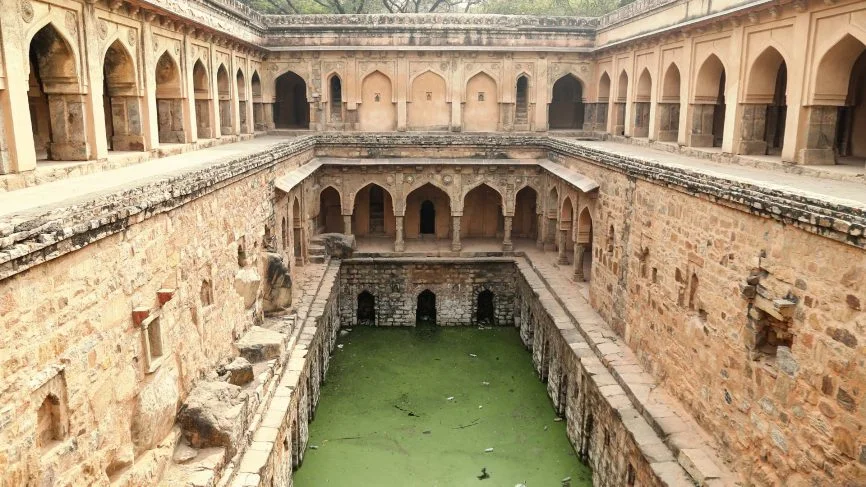
Baoli |
Stepwell structure with arches, carved motifs, and rooms. Integral to urban water storage in low-rainfall areas. |
Rajasthan, Delhi, Gujarat, Karnataka. E.g., Chandi Baori, Rajasthan, Agrasen ki Baoli, Delhi |
carvings, rooms, tiered steps, seasonal water collection. |
|
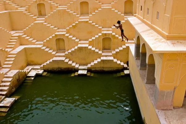
Jhalara |
Rectangular stepwells with tiered steps on three or four sides, designed to collect water from reservoirs or lakes. |
Rajasthan |
Tiered steps, rectangular shape. |
|
Talab/Bandhi |
Medium-sized reservoirs, natural or human-made, regulating water flow and preventing flooding. |
Various regions |
Reservoirs, water flow regulation. |
|
Taanka |
Cylindrical underground pit paved to collect rainwater from rooftops or catchment areas. |
Thar Desert, Rajasthan |
Underground, cylindrical, paved. |
|
Ahar Pynes |
Reservoirs with embankments, built at the end of diversion channels for harvesting floodwater. |
South Bihar |
Embankments, floodwater harvesting. |
|
Johads |
Earthen storage pits made by excavating three-sided elevated areas, with soil used for the fourth side. |
Various regions |
Earthen pits, elevated area excavation. |
|
Panam Keni |
Cylindrical wells made with soaked toddy palm stems, considered sacred. |
Wayanad, Kerala |
Cylindrical, sacred, toddy palm stems. |
|
Khadin (Dhora) |
Long earthen embankments across hill slopes collecting surface runoff for agriculture. |
Jaisalmer, Rajasthan |
Earthen embankments, surface runoff collection. |
|
Kund |
Saucer-shaped catchment area with a central circular underground well, traditionally lined with lime and ash. |
Various regions across India. |
Catchment area, circular well, traditional lining. |
|
Zing |
Small tanks in Ladakh collect glacier meltwater, turning into streams by afternoon. |
Ladakh |
Small tanks, glacier water collection. |
|
Kuhls |
Surface water channels in Himachal Pradesh carrying glacial waters to fields. |
Himachal Pradesh |
Surface channels, glacial water. |
|
Zabo |
System in Nagaland combining water conservation with forestry, agriculture, and animal care. |
Nagaland |
Rainwater collection, pond-like structures, terraced hillsides. |
|
Jackwells |
Pits surrounded by bunds made of hardwood logs, practiced by the Shompen tribe. |
Great Nicobar Islands |
Pits, hardwood bunds. |
Water Management in Indian History
- Indus Valley Civilization: Dholavira had reservoirs to collect rainwater, while Lothal and Inamgaon had small bunds built to store water for irrigation and drinking.
- Mauryan Empire: The Arthashastra of Kautilya records extensive irrigation systems, including dams and bunds, managed under strict regulations.
- Taxes were imposed based on the source and method of water extraction.
- Early Medieval India: The Satavahanas introduced brick and ring wells.
- The Chola period saw advanced systems like chain tanks (interconnected tanks) for efficient water distribution.
- The Rajputs built large reservoirs, such as the Bhopal Lake under King Bhoja, while the Pal and Sen dynasties constructed numerous tanks and lakes in eastern India.
- Medieval Period: Feroze Shah Tughlaq built the Western Yamuna Canal, while Emperor Shahjahan developed the Bari Doab or Hasli Canal.
- The Vijayanagar Kingdom constructed tanks like the Anantraj Sagar and Korangal Dam.
- Sultan Zain Uddin established an extensive canal network in Kashmir.
What is a Water Harvesting System?
- About: A water harvesting system refers to a technique or structure designed to capture, store, and use rainwater, surface runoff, or other sources of water for various purposes, such as agriculture, domestic use, and groundwater recharge.
- It is a sustainable water management practice aimed at conserving water and addressing water scarcity.
- Types:
- Rainwater Harvesting (RWH): Collecting and storing rainwater through methods like rooftop collection and underground storage to conserve water.
- Groundwater Recharge Systems: Techniques such as recharge wells that allow rainwater to seep into the ground to maintain and improve groundwater levels.
- Surface Water Harvesting: Collecting rainwater from land or open fields using ponds and reservoirs for irrigation and other uses.
- Urban Water Harvesting: Capturing rainwater in cities from rooftops and surfaces to reduce pressure on municipal water systems and manage stormwater.
- Significance:
- Reliable Water Source: Ensures a dependable water supply with minimal evaporation or pollution, suitable for daily use. Enhances groundwater quality and combats seawater intrusion in coastal areas.
- Flood Prevention: Reduces flood risk and water logging, protecting property and infrastructure. Protects the environment and property by minimizing erosion and flooding.
- Groundwater Recharge: Replenishes groundwater, enhancing availability during dry periods. Minimizes surface runoff, preserving soil and preventing sedimentation in water bodies.
- Sustainability: Supports water conservation and combats groundwater depletion amidst urbanization.
What are India's Initiatives Related to Water Conservation?
Conclusion
India's rich history in water harvesting, from ancient systems like Jhalaras and Baolis to modern initiatives like the Jal Jeevan Mission, highlights its deep-rooted expertise in sustainable water management. Both historical and contemporary approaches emphasize innovative water conservation, ensuring water accessibility and supporting agriculture in diverse climatic regions across the country.
|
Drishti Mains Question: Discuss the traditional water conservation methods practiced in different parts of India. |
UPSC Civil Services Examination, Previous Year Questions (PYQs)
Prelims
Q. What are the benefits of implementing the ‘Integrated Watershed Development Programme’? (2014)
- Prevention of soil runoff
- Linking the country’s perennial rivers with seasonal rivers
- Rainwater harvesting and recharge of groundwater table
- Regeneration of natural vegetation
Select the correct answer using the code given below:
(a) 1 and 2 only
(b) 2, 3 and 4 only
(c) 1, 3 and 4 only
(d) 1, 2, 3 and 4
Ans: (c)
Q. Which of the following practices can help in water conservation in agriculture? (2017)
- Reduced or zero tillage of the land
- Applying gypsum before irrigating the field
- Allowing crop residue to remain in the field
Select the correct answer using the code given below:
(a) 1 and 2 only
(b) 3 only
(c) 1 and 3 only
(d) 1, 2 and 3
Ans: (c)
Mains
Q. What is water stress? How and why does it differ regionally in India? (2019)
Q. “The ideal solution to depleting ground water resources in India is water harvesting system”. How can it be made effective in urban areas? (2018)
Q. Enumerate the National Water Policy of India. Taking river Ganges as an example, discuss the strategies which may be adopted for river water pollution control and management. What are the legal provisions of management and handling of hazardous wastes in India? (2013)


Important Facts For Prelims
Hornbill Festival
Why in News?
The Prime Minister of India has congratulated the people of Nagaland on the completion of 25 years of the Hornbill Festival.
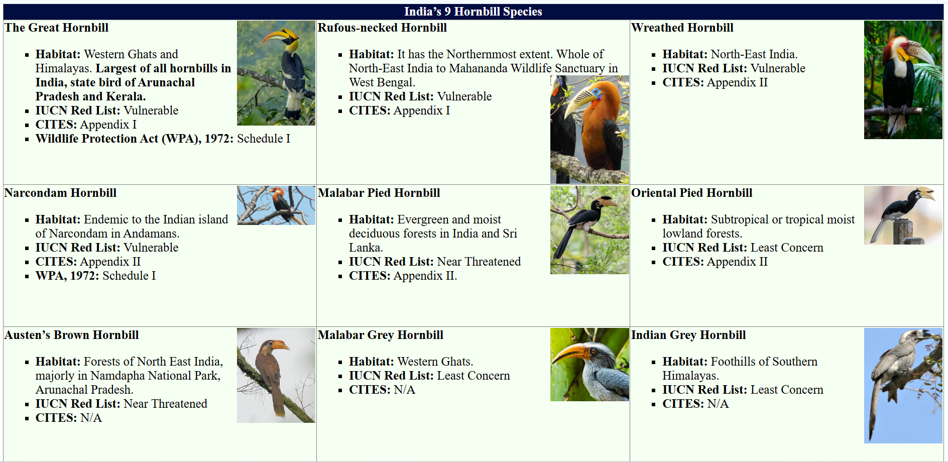
- Nagaland is known as the land of festivals, and the Hornbill festival is referred to as the festival of festivals.
What is the Hornbill Festival?
- About: The Hornbill Festival, initiated in 2000, is Nagaland’s premier cultural event, showcasing the heritage of its 17 Naga tribes. Held from 1st December to 10th December, it coincides with Nagaland Statehood Day(1st December).
- Hornbill Festival is named after the hornbill bird, a symbol of fidelity, beauty, and grace in Naga folklore.
- Cultural Celebration: Hornbill Festival serves as a platform for the Naga tribes to display their rich traditions through performances, dances, and exhibitions.
- Warriors, dressed in full ceremonial attire, perform traditional dances and war cries that narrate stories of victories, harvests, love, and tribal legends.
- Their distinctive attire features hornbill feathers, boar tusks, and colorful woven sashes, creating a striking display of Naga heritage and pride.
- It serves as the state's largest tourist event, attracting over 1.5 lakh visitors in 2023, including international tourists.
- Warriors, dressed in full ceremonial attire, perform traditional dances and war cries that narrate stories of victories, harvests, love, and tribal legends.
Hornbill
- The Great Indian Hornbill (Buceros bicornis), also known as the Concave-Casqued Hornbill, is a large bird found in the Indian subcontinent and Southeast Asia.
- It primarily inhabits evergreen and moist deciduous forests.
- It thrives in the canopy of tall trees in the Western Ghats, northeastern states, and the Himalayas.
- It is the state bird of Arunachal Pradesh and Kerala. India hosts nine hornbill species, with the northeast having the highest diversity.
What are the Key Facts About Nagaland?
- Statehood: Nagaland became the 16th state of India on 1st December 1963.
- Borders: Assam (west and northwest), Myanmar (east), Arunachal Pradesh and Manipur (south).
- State Symbols: Blyth’s tragopan (State Bird) and Mithun (State Animal of Nagaland and Arunachal Pradesh).
- The mithun (Bos frontalis) a bovine species, native to Northeast India, is now recognized by Food Safety and Standards Authority of India (FSSAI) as a 'food animal', enabling its commercial farming and meat processing.
- GI Products: Naga tree tomato, Naga cucumber, and Naga Mircha (chili).
- Protected Areas: Intanki National Park, Fakim Wildlife Sanctuary, Singphan Wildlife Sanctuary, and Pulie Badze Wildlife Sanctuary.
- Tribes and Culture: Home to 17 major tribes and numerous sub-tribes, each with distinct customs, languages, and attire.
UPSC Civil Services Examination, Previous Year Questions (PYQs)
Prelims
Q. In which of the following regions of India are you most likely to come across the ‘Great Indian Hornbill’ in its natural habitat? (2016)
(a) Sand deserts of northwest India
(b) Higher Himalayas of Jammu and Kashmir
(c) Salt marshes of western Gujarat
(d) Western Ghats
Ans: (d)


Important Facts For Prelims
Challenging Big Bang Theory
Why in News?
Recent observations from the James Webb Space Telescope (JWST) have revealed the existence of massive, fully-formed galaxies and black holes as early as 400-650 million years after the Big Bang.
- This challenges the Big Bang Theory’s standard model, which posits that galaxies took billions of years to form after the universe's creation.
What are Key Highlights of the Study?
- Challenge to Big Bang Theory: NASA’s JWST has discovered a surprising number of massive, fully-formed galaxies just 400-650 million years after the Big Bang. This challenges the Big Bang Theory, which states that the universe started as an extremely hot and dense point (singularity) 13.8 billion years ago, and galaxies were thought to form much later, over billions of years.
- These early, mature galaxies don’t fit with the current understanding of how the universe evolved.
- Black Holes as Indicators: Black holes (referred as little red dots), especially supermassive ones at the centres of galaxies, serve as key indicators of a galaxy's formation and evolution.
- The amount of heat and light emitted by the blackhole helps in accurately measuring the mass of stars in galaxies.
- Reason for Massive Galaxies in Early Universe: One possible explanation for a larger number of massive galaxies in the early universe is that these galaxies manufactured stars more efficiently than the galaxies of today.
- Role of JWST: It has a 6.5 m wide primary mirror and is specifically designed for infrared observations with a focus on studying the early universe.
- Observations in the infrared spectrum allows researchers to detect light from the earliest galaxies and see through dust clouds and identify celestial objects that are otherwise obscured.
Big Bang Theory
- Origin of the Universe: Proposed by Georges Lemaître in 1927, the Big Bang Theory explains how the universe began as a single, infinitely small and hot point that expanded and stretched to create the vast universe.
- Evidence and Confirmation: Edwin Hubble later confirmed this idea by observing galaxies moving away from us, indicating that the universe is still expanding.
- Visible and ultraviolet light from distant galaxies shift to the infrared wavelengths as the universe expands.
- Formation of Celestial Bodies: As the universe expanded, it cooled, allowing particles to form atoms, which then combined to create celestial bodies such as planets, asteroids, comets, and black hole.
UPSC Civil Services Examination, Previous Year Question (PYQ)
Prelims:
Q.The terms ‘Event Horizon’, ‘Singularity’, ‘String Theory’ and ‘Standard Model’ are sometimes seen in the news in the context of (2017)
(a) Observation and understanding of the Universe
(b) Study of the solar and the lunar eclipses
(c) Placing satellites in the orbit of the Earth
(d) Origin and evolution of living organisms on the Earth
Ans: (a)
Q. Which of the following is/are cited by the scientists as evidence/evidences for the continued expansion of universe? (2012)
- Detection of microwaves in space
- Observation of redshift phenomenon in space
- Movement of asteroids in space
- Occurrence of supernova explosions in space
Select the correct answer using the codes given below:
(a) 1 and 2
(b) 2 only
(c) 1, 3 and 4
(d) None of the above can be cited as evidence
Ans: (a)
Q. Which of the following pairs is/are correctly matched? (2008)
Theory/Law Associated Scientist
- Continental Drift : Edwin Hubble
- Expansion of Universe : Alfred Wegener
- Photoelectric Effect : Albert Einstein
Select the correct answer using the code given below:
Code:
(a) 2 and 3 only
(b) 3 only
(c) 2 only
(d) 1 only
Ans: (b)


Rapid Fire
World Soil Day 2024
World Soil Day is held annually on 5th December focussing on healthy soil and advocating for the sustainable management of soil resources.
- Theme: Caring for soils: measure, monitor, manage.
- Adoption: It was adopted by the UN General Assembly in December 2013, with the first World Soil Day observed on 5th December 2014.
- 5th December marks the birth anniversary of the late King Bhumibol Adulyadej of Thailand, a key supporter of this initiative.
- Conservation Efforts: In India, Mitti Bachao (Save the Soil) Movement started in Hoshangabad (Narmadapuram), Madhya Pradesh in 1977 against soil degradation caused by the Tawa Dam in Madhya Pradesh.
- Over 95% of our food comes from soils. Besides, they supply 15 of the 18 naturally occurring chemical elements essential to plants.
- Sustainable Soil Management Practices: Minimum tillage, crop rotation, organic matter addition, and cover cropping.
Read More: Global Soil Conference 2024 and Soil in India


Rapid Fire
Recovery in Core Sectors
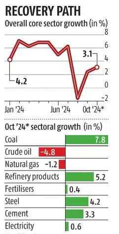
The output of India’s eight core sectors recorded a 3.1% year-on-year growth in October 2024, marking the highest performance in three months.
- However, this growth is relatively modest compared to the 12.7% seen in October 2023.
- Eight Core Sectors: It consists of cement, coal, crude oil, electricity, fertilizers, natural gas, refinery products, and steel.
- It accounts for over 40% of industrial production.
- The Index of Core Industries (ICI), a metric that measures the combined performance of production across eight key industries in India .
- The ICI is released monthly by the Office of the Economic Adviser (OEA), DPIIT, Ministry of Commerce & Industry.
- The current weightage of the eight core industries is: Petroleum Refinery Products (28.04%), Electricity (19.85%), Steel (17.92%), Coal (10.33%), Crude Oil (8.98%), Natural Gas (6.88%), Cement (5.37%), and Fertiliser (2.63%).
- The base year for the current ICI series is 2011-12.
Read More: Core Sector Industries.


Rapid Fire
Turner Prize 2024
Recently, Jasleen Kaur, an Indian-origin Scottish artist, won the prestigious Turner Prize 2024 for her exhibition “Alter Altar”, showcasing a blend of personal, political, and spiritual themes.
- Alter Altar featured everyday objects like a doily-covered car and family photos, blending cultural symbols to explore the Sikh concept of Miri Piri (political-spiritual balance), offering new perspectives on coexistence through art.
- Turner Prize: It was established in 1984, founded by a group called the Patrons of New Art, and is one of the most esteemed awards in contemporary British art.
- This year marked the 40th anniversary of the award. Previous Indian-origin winner: Anish Kapoor (1991).
Read more: Booker Prize 2024


Rapid Fire
Agroforestry's Impact to Endemic Frogs
A recent study by the Nature Conservation Foundation (NCF-India) and the Bombay Environmental Action Group (BEAG) assessed the impact of agroforestry on endemic frog species in the northern Western Ghats.
- Findings of the Study: Amphibian diversity was lowest in paddy fields; abundance was least in orchards compared to undisturbed plateaus.
- Endemic species like CEPF burrowing frog (Minervarya cepfi) and Goan fejervarya (Minervarya gomantaki) were less abundant in modified habitats.
- Generalist species like Minervarya syhadrensis were more common in paddy fields indicating habitat-driven shifts.
- Western Ghats: Western Ghats, made up of lateritic plateaus (flat-topped landscapes rich in iron and aluminum) were formed millions of years ago through volcanic activity.
- It is a biodiversity hotspot and home to around 252 amphibian species, including 226 frogs.
- However, globally, 40.7% of amphibian species (8,011 species) are threatened due to habitat destruction, pollution, climate change, and diseases like chytridiomycosis.
Read More: Charles Darwin's Frog


