Geography
India Joins Sri Lanka in Seabed Mining Race
- 29 Mar 2024
- 20 min read
For Prelims: Indian Ocean Seabed, Cobalt-Rich Afanasy Nikitin Seamount (AN Seamount), International Seabed Authority (ISBA), United Nations Convention on the Law of the Sea (UNCLOS), Internal Waters, Territorial Sea, Contiguous Zone, Exclusive Economic Zone (EEZ), Continental Self, Bay of Bengal
For Mains: Economic and diplomatic significance of the right to explore the Indian Ocean sea bed
Why in News?
Recently, India applied for Rights to Explore the Indian Ocean Seabed Beyond its Jurisdiction, Including Cobalt-Rich Afanasy Nikitin Seamount (AN Seamount). India's interest is fueled by concerns over Chinese vessels conducting reconnaissance there.
- Rights to the region have already been claimed by Sri Lanka under a separate set of laws.
What is Afanasy Nikitin Seamount (AN Seamount)?
- The AN Seamount is a structural feature (400 km long and 150 km wide) in the Central Indian Basin, located about 3,000 km away from India’s coast.
- From an oceanic depth of about 4,800 km, it rises to about 1,200 meters and it is rich in deposits of cobalt, nickel, manganese and copper.
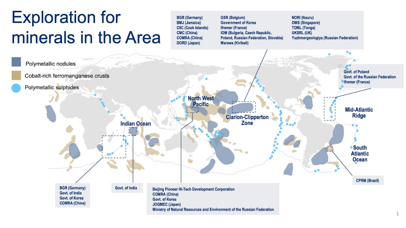
- To proceed with extraction, interested parties/countries must first apply for an exploration license to the International Seabed Authority (ISBA). This organisation operates autonomously under the United Nations Convention on the Law of the Sea (UNCLOS).
- These rights are specific to areas that are part of the open ocean. Around 60% of the world’s seas are open ocean and though believed to be rich in a variety of mineral wealth, the costs and challenges of extraction are prohibitive.
Which Countries have been Provided with Exploration Licences?
- Both state-owned and government-sponsored companies from India, France, Russia, Germany, China, Singapore and the UK had sought permission for minerals prospecting in the high seas.
- Licence Granted:
- Four licences have been granted for the Pacific Ocean, the Clarion Clipperton Zone between Hawaii and Mexico and the Magellan Seamount in the northwest Pacific.
- Two licences are for the Indian Ocean Ridge, while one for Rio Grande Rise in the southern Atlantic.
- India's Exploration Applications: Along with the application for AN Seamount, India has also applied for permission to explore another region, spanning 3,00,000 square km, called the Carlsberg Ridge in the Central Indian Ocean to investigate for polymetallic sulphides, which are large smoking mounds near hydrothermal vents that are reportedly rich in copper, zinc, gold and silver.
- Previous Exploration Efforts: India has previously secured exploration rights to two other large basins in the Central Indian Ocean and has undertaken surveys in these regions, demonstrating its commitment to marine exploration and resource assessment.
- India has been studying the seabed and carrying out test mining for about two decades through institutes like National Institute of Oceanography (NIO) and National Institute of Ocean Technology (NIOT) .
What is Deep Sea Bed Mining?
- Deep-sea mining involves extracting valuable mineral deposits from the ocean floor at depths ranging from 200 to 6,500 meters below the surface.
- These mineral deposits include materials such as copper, cobalt, nickel, zinc, silver, gold, and rare earth elements.
- NIO has tested deep-sea mining systems up to 512 meters depth and is working on systems for up to 6,000 meters.
- Establishing deep-sea mines was earlier considered more expensive than land-based mining.
- Innovations in underwater robotics from the petroleum industry have improved prospects for deep-sea mining.
What are the Different Maritime Zones?
- Baseline:
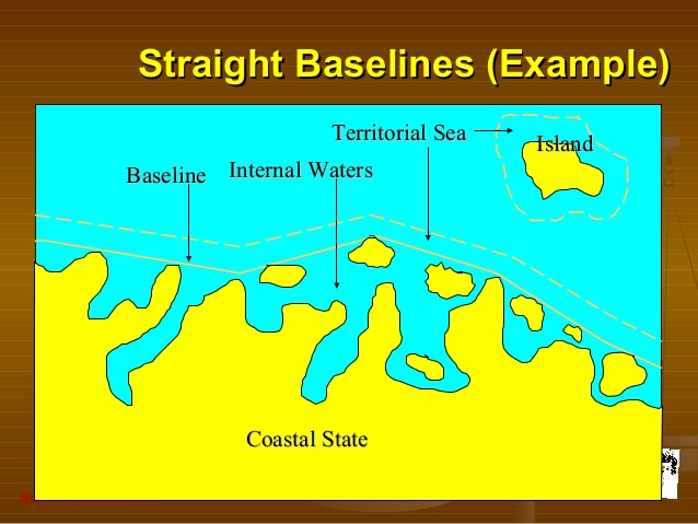
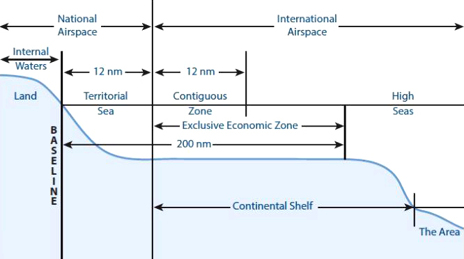
- A baseline refers to a line, often along the coastline, serving as a reference point for measuring the outer boundaries of a state's territorial sea and other maritime zones, such as its exclusive economic zone.
- Typically, this baseline mirrors the low-water mark of the coastal state. In cases where the coastline is deeply indented, contains islands close to the shore, or exhibits significant instability, straight baselines may be established instead.
- Internal Waters:
- Internal waters are waters on the landward side of the baseline from which the breadth of the territorial sea is measured.
- Each coastal state has full sovereignty over its internal waters as like its land territory. Examples of internal waters include bays, ports, inlets, rivers and even lakes that are connected to the sea.
- There is no right to innocent passage through internal waters.
- The innocent passage refers to the passing through the waters which are not prejudicial to peace and security. However, the nations have the right to suspend the same.
- Territorial Sea:
- The territorial sea extends seaward up to 12 nautical miles (nm) from its baselines.
- The coastal states have sovereignty and jurisdiction over the territorial sea. These rights extend not only to the surface but also to the seabed, subsoil, and even airspace.
- However, the coastal states’ rights are limited by the innocent passage through the territorial sea.
- The territorial sea extends seaward up to 12 nautical miles (nm) from its baselines.
- Contiguous Zone:
- The contiguous zone adjacent to and beyond its territorial sea that extends seaward up to 24 nm from its baselines.
- It is an intermediary zone between the territorial sea and the high seas.
- The coastal state has the right to both prevent and punish infringement of fiscal, immigration, sanitary, and customs laws within its territory and territorial sea.
- Unlike the territorial sea, the contiguous zone only gives jurisdiction to a state on the ocean’s surface and floor. It does not provide air and space rights.
- Exclusive Economic Zone (EEZ):
- Each coastal State may claim an EEZ beyond and adjacent to its territorial sea that extends seaward up to 200 nm from its baselines.
- Within its EEZ, a coastal state has:
- Sovereign rights to explore, exploit, conserve and manage natural resources, whether living or nonliving, of the seabed and subsoil.
- Rights to carry out activities like the production of energy from the water, currents and wind.
- Unlike the territorial sea and the contiguous zone, the EEZ only allows for the above-mentioned resource rights. It does not give a coastal state the right to prohibit or limit freedom of navigation or overflight, subject to very limited exceptions.
- Continental Self:
- A continental shelf is the edge of a continent that lies under the ocean. A continental shelf extends from the coastline of a continent to a drop-off point called the shelf break.
- From the break, the shelf descends toward the deep ocean floor in what is called the continental slope.
- A continental shelf is the edge of a continent that lies under the ocean. A continental shelf extends from the coastline of a continent to a drop-off point called the shelf break.
- High Seas:
- The ocean surface and the water column beyond the EEZ are referred to as the high seas.
- It is considered as “the common heritage of all mankind” and is beyond any national jurisdiction.
- States can conduct activities in these areas as long as they are for peaceful purposes, such as transit, marine science, and undersea exploration.
What are the Continental Shelf Claims and Exploration Rights?
- Exclusive Rights to Continental Shelf: Countries possess exclusive rights up to 200 nautical miles from their borders, including the underlying seabed. This jurisdiction extends to the exploration and potential exploitation of resources within this zone.
- Continental Shelf Extension: Some ocean-bound states may have a natural land formation connecting their border to the edge of the deep ocean, extending beyond the 200-nautical-mile limit. This extension is known as the continental shelf.
- Special Provisions: There is a provision allowing countries along the Bay of Bengal to apply a different set of criteria for making claims on the extent of their continental shelf.
- Example: Utilising a special provision, Sri Lanka has asserted a claim for an extension of its continental shelf up to 500 nautical miles, exceeding the usual limit of 350 nautical miles.
- Rational Support to Claim: To claim exclusive rights to the continental shelf beyond 200 nautical miles, a country must provide a detailed scientific rationale supported by underwater maps and surveys. This information is submitted to a scientific commission appointed by the International Seabed Authority (ISBA).
- If the claim is approved by the commission, the country gains primacy to explore and potentially exploit both living and non-living resources within the extended continental shelf.
What is the Significance of Deep Sea Mining?
- Resource Accessibility: Deep sea mining provides access to valuable resources that are becoming increasingly scarce on land. These resources include polymetallic nodules, polymetallic sulphides, and cobalt-rich ferromanganese crusts, which contain high concentrations of minerals such as copper, nickel, cobalt, and rare earth elements.
- As terrestrial deposits become depleted, deep-sea mining offers an alternative source of these critical materials.
- Technological Advancements: Developing technologies for deep-sea mining presents opportunities for innovation and technological advancement. This includes the design of specialised equipment capable of operating in extreme oceanic conditions, such as high pressure, darkness, and low temperatures.
- Advancements in robotics, remotely operated vehicles (ROVs), and autonomous underwater vehicles (AUVs) are essential for efficient and safe mining operations.
- Economic Potential: Deep sea mining has the potential to generate significant economic benefits for participating countries and companies.
- The extraction of valuable minerals from the ocean floor can stimulate economic growth, create employment opportunities, and contribute to national revenue through taxes, royalties, and resource-sharing agreements.
What are the Concerns Related to Deep Sea Mining?
- Damage to Marine Ecosystem: Deep Sea Mining can damage the Marine Ecosystem and ecosystems. Damage from mining can include noise, vibration and light pollution, as well as possible leaks and spills of fuels and other chemicals used in the mining process.
- It could severely harm marine biodiversity and ecosystems,
- Sediment Plumes Formation: It will stir up fine sediments on the seafloor, creating plumes of suspended particles. Once valuable materials are extracted, slurry sediment plumes are sometimes pumped back into the sea.
- That can harm filter-feeding species like corals and sponges and could smother or otherwise interfere with some creatures.
- Wider Impact on Marine Population: Deep-sea mining would go beyond harming the seabed and have a wider impact on fish populations, marine mammals and the essential function of the deep-sea ecosystems in regulating the climate.
- Digging & Gauging: The digging and gauging of the ocean floor by machines can alter or destroy deep-sea habitats and can harm yet unknown species of greater depth at sea.
United Nations Convention on the Law of the Sea 1982
- About:
- The UNCLOS is an international treaty that provides a regulatory framework for the use of the world’s seas and oceans.
- It lays down a comprehensive regime of law and order in the world's oceans and seas establishing rules governing all uses of the oceans and their resources.
- It enshrines the notion that all problems of ocean space are closely interrelated and need to be addressed as a whole.
- Ratification:
- The Convention was opened for signature in December 1982 in Montego Bay, Jamaica.
- The convention has been ratified by 168 parties, which includes 167 states (164 United Nations (UN) member states plus the UN Observer state Palestine, as well as the Cook Islands and Niue) and the European Union. An additional 14 UN member states have signed, but not ratified the convention.
- While India ratified UN Law of the Seas in 1995, the US has failed to do it so far.
- Indian Law:
- As per India’s Territorial Waters, Continental Shelf, Exclusive Economic Zone and Other Maritime Zones Act, 1976:
- All foreign ships (other than warships including submarines and other underwater vehicles) shall enjoy the right of innocent passage through the territorial waters.
- Innocent passage: It is the passage that is not prejudicial to the peace, good order or security of India.
- All foreign ships (other than warships including submarines and other underwater vehicles) shall enjoy the right of innocent passage through the territorial waters.
- As per India’s Territorial Waters, Continental Shelf, Exclusive Economic Zone and Other Maritime Zones Act, 1976:
What are other Blue Economy Initiatives?
- India-Norway Task Force on Blue Economy for Sustainable Development:
- Sagarmala project
- O-SMART
- Integrated Coastal Zone Management
- National Fisheries policy
Way Forward
- Regulatory Framework Enhancement: Strengthening regulations and international agreements to ensure responsible and sustainable deep-sea mining practices are essential. This includes setting stringent guidelines for noise, vibration, and light pollution, as well as strict protocols for the handling and disposal of mining by-products and chemicals.
- Environmental Impact Assessments: Conducting thorough environmental impact assessments before granting mining licenses is crucial. These assessments should evaluate potential damage to marine ecosystems, biodiversity, and habitats, as well as the long-term effects on fish populations and marine mammals.
- Mitigation Measures: Implementing effective mitigation measures to minimize the impact of deep-sea mining activities is vital. This could involve using advanced technologies to reduce noise and light pollution, employing sediment control measures to prevent the spread of suspended particles, and developing innovative methods for waste management and disposal.
- Monitoring and Enforcement: Establishing robust monitoring mechanisms to track the environmental impact of deep-sea mining operations is necessary. Regular inspections and enforcement of regulations can ensure compliance with environmental standards and prompt intervention in case of any violations.
Read more: Deep Sea Mining, Deep Sea Mining and its Threats, India’s Deep Ocean Mission
UPSC Civil Services Examination Previous Year Question (PYQ) nation
Prelims
Q1. With reference to ‘Indian Ocean Rim Association for Regional Cooperation (IOR-ARC)’, consider the following statements: (2015)
- It was established very recently in response to incidents of piracy and accidents of oil spills.
- It is an alliance meant for maritime security only.
Which of the statements given above is/ are correct?
(a) 1 only
(b) 2 only
(c) Both 1 and 2
(d) Neither 1 nor 2
Ans: (d)
Exp:
- Indian Ocean Rim Association for Regional Cooperation (IOR-ARC) is a regional cooperation initiative of the Indian Ocean Rim countries which was established in Mauritius in March 1997 with the aim of promoting economic and technical cooperation among its members. Hence, statement 1 is not correct.
- IOR-ARC is the only pan-Indian ocean grouping. It has 23 Member States and 9 Dialogue Partners.
- It aims to create a platform for trade, and socio-economic and cultural cooperation in the Indian Ocean Rim area, which constitutes a population of about two billion people. Hence, statement 2 is not correct.
- The Indian Ocean Rim is rich in strategic and precious minerals, metals and other natural resources, marine resources, and energy, all of which can be sourced from Exclusive Economic Zones (EEZ), continental shelves, and the deep seabed. Therefore, option (d) is the correct answer.
Q2. Consider the following statements: (2021)
- The Global Ocean Commission grants licences for seabed exploration and mining in international waters.
- India has received licences for seabed mineral exploration in international waters
- ‘Rare earth minerals’ are present on the seafloor in international waters.
Which of the statements given above are correct?
(a) 1 and 2 only
(b) 2 and 3 only
(c) 1 and 3 only
(d) 1, 2 and 3
Ans: (b)
Mains
Q. Critically evaluate the various resources of the oceans which can be harnessed to meet the resource crisis in the world. (2014)

.png)


