Rajasthan’s River-Link Project | 14 Jan 2025
Why in News?
The proposed river-linking project in Rajasthan, which aims to address the state’s growing water scarcity, has sparked significant debate over its potential environmental impact.
- The canal project is expected to channel surplus water of the Chambal river basin for irrigation, drinking and industrial use to 23 districts of Rajasthan, benefitting 3.45 crore people.
Key Points
- This river linking project is mounting over the possible submergence of approximately 37 square kilometers within the Ranthambore Tiger Reserve.
- The submergence will be caused by the largest dam proposed under the Parbati-Kalisindh-Chambal-Eastern Rajasthan Canal Project (PKC-ERCP), which is part of the ambitious Interlinking of Rivers (ILR) program.
- The PKC-ERCP project in Rajasthan involves a total submergence area of 408.86 sq km. Of this, 227 sq km will be submerged under the reservoir of a proposed dam across the Banas River, a Chambal tributary.
- The dam, planned to be 39 meters high and 1.6 km long, will be located near Doongri village, about 30 km from Sawai Madhopur.
- The project details show, 37.03 sq km belong to Ranthambore National Park (392 sq km) and Keladevi Wildlife Sanctuary (674 sq km), both part of the Ranthambhore tiger reserve (1,113 sq km), currently home to 57 tigers.
- Ranthambhore is the third tiger reserve facing loss of land to upcoming reservoirs.
- The PKC-ERCP project in Rajasthan involves a total submergence area of 408.86 sq km. Of this, 227 sq km will be submerged under the reservoir of a proposed dam across the Banas River, a Chambal tributary.
- The environmental cost of the project has become a contentious issue. Conservationists warn that submerging parts of the Ranthambore Tiger Reserve could threaten the biodiversity of one of India’s most celebrated wildlife sanctuaries.
- Ranthambore, home to a stable population of tigers and other species, plays a crucial role in the nation’s conservation efforts.
Note:
- Other projects that are facing land loss include:
- The North Koel Reservoir Project will submerge 10.07 sq km of Palamu tiger reserve in Jharkhand, the Ken-Betwa river link project is expected to drown 41.41 sq km of Panna tiger reserve in Madhya Pradesh.
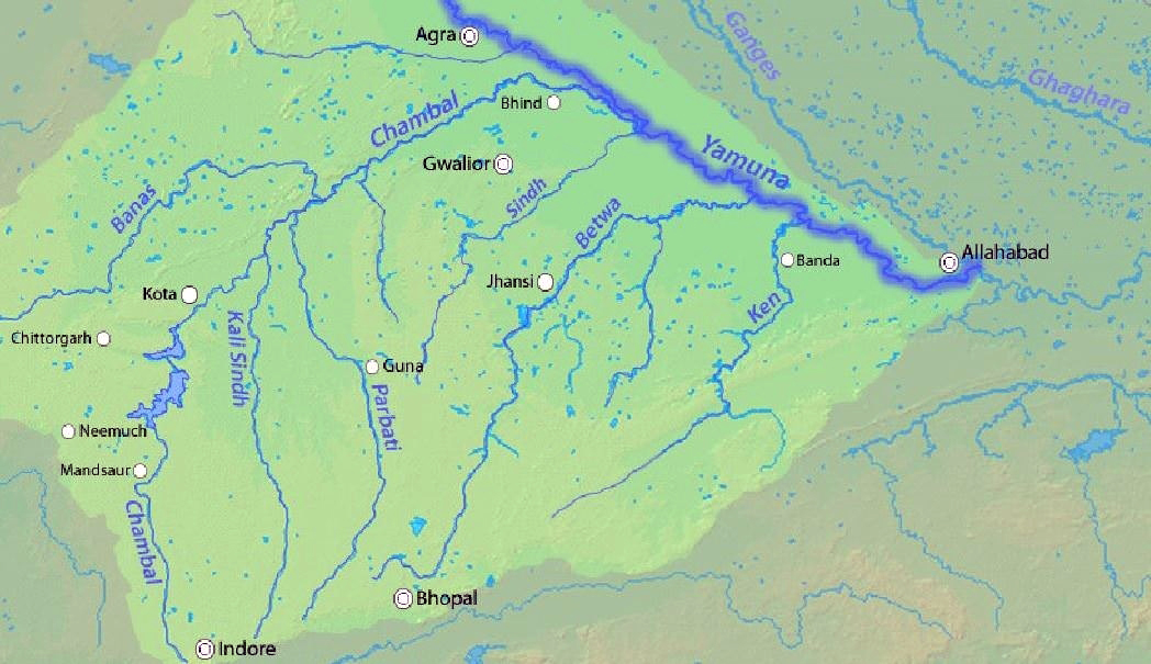
Chambal River
- Chambal River originates at the Singar Chouri peak in the northern slopes of the Vindhya mountains (Indore, Madhya Pradesh). From there, it flows in the North direction in Madhya Pradesh for a length of about 346 km and then follows a north-easterly direction for a length of 225 km through Rajasthan.
- It enters Uttar Pradesh and flows for about 32 km before joining the Yamuna River in Etawah District.
- It is a rainfed river and its basin is bounded by the Vindhyan mountain ranges and the Aravallis. The Chambal and its tributaries drain the Malwa region of northwestern Madhya Pradesh.
- The Hadauti plateau in Rajasthan occurs in the upper catchment of the Chambal River to the southeast of the Mewar Plains.
- Tributaries: Banas, Kali Sindh, Sipra, Parbati, etc.
- Main Power Projects/ Dam: Gandhi Sagar Dam, Rana Pratap Sagar Dam, Jawahar Sagar Dam, and Kota Barrage.
- The National Chambal Sanctuary is located along river Chambal on the tri-junction of Rajasthan, Madhya Pradesh and Uttar Pradesh.
- It is known for critically endangered gharial, the red-crowned roof turtle, and the endangered Ganges river dolphin.

 1.jpg)
.png)
