Biodiversity & Environment
MP-Rajasthan MoU on PKC-ERCP Link Project
- 03 Oct 2024
- 11 min read
For Prelims: Parbati-Kalisindh-Chambal (PKC) Linking Project, Eastern Rajasthan Canal Project (ERCP), National Perspective Plan for Interlinking Rivers, Chambal basin, Vindhya mountains, Yamuna River, National Interlinking of Rivers Authority (NIRA)
For Mains: Interlinking of Rivers in India and associated issues, Issues Relating to Development, Water Management
Why in News?
Recently, a Memorandum of Understanding (MoU) was signed between Rajasthan and Madhya Pradesh to implement the Modified Parbati-Kalisindh-Chambal Eastern Rajasthan Canal Project (PKC-ERCP) river link project.
- This project is being implemented as part of the Government of India's National Perspective Plan (NPP) for the interlinking of rivers (ILR).
What is the Modified PKC-ERCP?
- Parbati-Kalisindh-Chambal (PKC): It is a river-linking initiative designed to divert surplus water from the Parbati, Newaj, and Kalisindh rivers to the Chambal River.
- It is part of the 30 links in the National Perspective Plan (1980), formulated by the Central Water Commission and the Union Ministry of Irrigation.
- It aims to provide water for domestic use, optimise water resources within the Chambal basin, and benefit regions in Madhya Pradesh and Rajasthan.
- Rivers Involved in the Project:
- Chambal River:
- Origin: Singar Chouri Peak, Vindhya Mountains, Indore, Madhya Pradesh.
- Major Tributaries: Banas, Kali Sindh, Sipra, Parbati.
- Parvati River:
- Origin: Vindhya Range, Sehore District, Madhya Pradesh.
- Significant Tributaries: None.
- Kali Sindh River:
- Origin: Bagli, Dewas District, Madhya Pradesh.
- Major Tributaries: Parwan, Newaj, Ahu.
- Chambal River:
- Eastern Rajasthan Canal Project (ERCP): The ERCP was proposed by Rajasthan in 2019 to optimise water resources.
- It aims to facilitate intra-basin water transfer within the Chambal basin.
- It aims to harness surplus monsoon water from the Kalisindh, Parvati, Mej, and Chakan sub-basins and divert it to the water-deficient sub-basins of Banas, Gambhiri, Banganga, and Parbati.
- This initiative will supply drinking and industrial water to 13 districts in eastern Rajasthan, including Alwar, Bharatpur, Sawai Madhopur, and Jaipur.
- The ERCP aims to establish a network of water channels that will span 23.67% of Rajasthan's area and benefit 41.13% of the state's population.
- Benefits:
- The ERCP is expected to create an additional command area of 2 lakh hectares and provide irrigation to 4.31 lakh hectares.
- It aims to improve groundwater levels in rural Rajasthan, enhancing socio-economic conditions.
- The project also supports the Delhi-Mumbai Industrial Corridor (DMIC) by ensuring sustainable water sources to boost industrial growth and attract investment.
- Modified PKC-ERCP:
- The Modified Parbati-Kalisindh-Chambal-ERCP (PKC-ERCP) Link Project is an inter-state project that merges the PKC link with the Eastern Rajasthan Canal Project (ERCP).
- This integration addresses issues like water sharing, cost-benefit distribution, and water exchange between the concerned states.
- The Modified Parbati-Kalisindh-Chambal-ERCP (PKC-ERCP) Link Project is an inter-state project that merges the PKC link with the Eastern Rajasthan Canal Project (ERCP).
- Need of Such Project:
- Rajasthan, the largest state in India with a geographical area of 342.52 lakh hectares (10.4% of the country's total), has only 1.16% of the nation's surface water and 1.72% of its groundwater resources, as reported by the Water Resources Department of Rajasthan.
Chambal River
- About: It originates at janapav, south of Mhowtown, near manpur Indore, on the south slope of the Vindhya Range in Madhya Pradesh. From there, it flows in the North direction in Madhya Pradesh for a length of about 346 km and then follows a north-easterly direction for a length of 225 km through Rajasthan.
- It enters UP and flows for about 32 km before joining the Yamuna River in Etawah District.
- It is a rainfed river and its basin is bounded by the Vindhyan mountain ranges and the Aravallis. The Chambal and its tributaries drain the Malwa region of northwestern Madhya Pradesh.
- The Hadoti plateau in Rajasthan occurs in the upper catchment of the Chambal River to the southeast of the Mewar Plains.
- Tributaries: Banas, Kali Sindh, Sipra, Parbati, etc.
- Main Power Projects/ Dam: Gandhi Sagar Dam, Rana Pratap Sagar Dam, Jawahar Sagar Dam, and Kota Barrage.
- The National Chambal Sanctuary is located along the Chambal river on the tri-junction of Rajasthan, Madhya Pradesh, and Uttar Pradesh. It is known for the critically endangered gharial, the red-crowned roof turtle, and the endangered Ganges river dolphin.
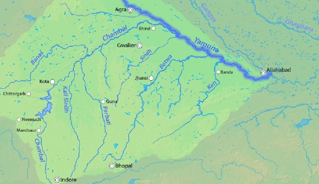
Yamuna
- The river Yamuna, a major tributary of river Ganges, originates from the Yamunotri glacier near Bandarpoonch peaks in the Mussoorie range of the lower Himalayas in Uttarkashi district of Uttarakhand.
- It meets the Ganges at the Sangam in Prayagraj, Uttar Pradesh after flowing through Uttarakhand, Himachal Pradesh, Haryana and Delhi.
- Important Dam: Lakhwar-Vyasi Dam (Uttarakhand), Tajewala Barrage Dam (Haryana) etc.
- Important Tributaries: Chambal, Sindh, Betwa and Ken.
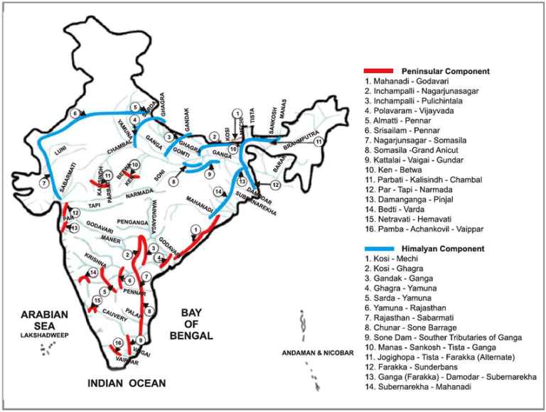
What is the National Perspective Plan for Interlinking Rivers?
- About:
- The River Interlinking Project, also known as the National Perspective Plan (NPP), formulated in 1980 by the Ministry of Jal Shakti is a large-scale civil engineering project that aims to transfer water from surplus basins to deficit basins in India.
- It involves the creation of artificial channels to connect rivers and water bodies.
- Components:
- Himalayan and Peninsular Rivers Development Component
- Projects Identified:
- A total of 30 link projects have been identified, with 16 under the Peninsular Component and 14 under the Himalayan Component.
- Key Projects Under Peninsular Component: Mahanadi-Godavari Links, Godavari-Krishna Links, Par-Tapi-Narmada Link, and Ken-Betwa Link (first project under the NPP to begin implementation).
- Key Projects Under Himalayan Component: Kosi-Ghagra Link, Ganga (Farakka)-Damodar-Subernarekha Link, and Kosi-Mechi Link.
- Significance:
- Flood Management: It aims to manage flood risks in flood prone areas such as Ganga-Brahmaputra-Meghna basin.
- Addressing Water Shortages: It seeks to mitigate water shortages in western and peninsular states, including Rajasthan, Gujarat, Andhra Pradesh, Karnataka, and Tamil Nadu.
- Irrigation Improvement: It aims to enhance irrigation in water-scarce regions, thereby boosting agricultural productivity and improving food security, with the potential to double farmers' incomes.
- Example: Ken-Betwa link project.
- Infrastructure Development: It facilitates the establishment of environmentally friendly inland waterways for efficient freight movement such as national waterway-1.
- Sustainable Water Use: It is designed to optimise surface water utilisation to alleviate groundwater depletion and minimise the freshwater flowing into the sea.
- Concerns:
- Biodiversity Loss: Altering natural river courses may lead to significant biodiversity loss and habitat disruption.
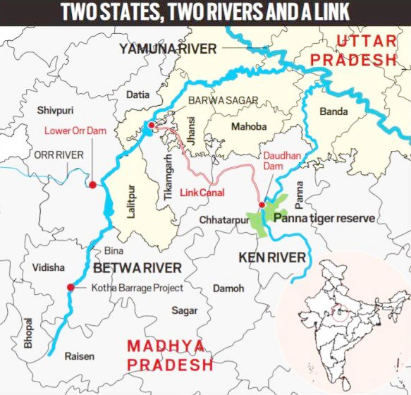
- Example: The Ken-Betwa link project in Madhya Pradesh is expected to submerge a significant portion of the Panna Tiger Reserve, leading to a loss of habitat for fauna.
- Community Displacement: River interlinking projects can displace local communities, raising important social and humanitarian issues.
- High Costs and Implementation Challenges: Significant investments, technical difficulties, and land acquisition issues.
- Failure of Similar Projects: The China’s South-to-North Water Diversion Project (SNWDP) has faced several challenges and negative consequences as it aimed to move water from the Yangtze River in the south to the Yellow River Basin in the north.
- Interstate Water Disputes: Conflicts and competition among states for limited water resources. Examples: Krishna Water Dispute
- Other concerns: Social impacts, long-term sustainability, and potential for exacerbating existing problems.
- Biodiversity Loss: Altering natural river courses may lead to significant biodiversity loss and habitat disruption.
Ken-Betwa River Link Project (KBLP)
- It is the first project under the National Perspective Plan (NPP) for the interlinking of rivers.
- The KBLP involves transferring water from the Ken River in Madhya Pradesh to the Betwa River in Uttar Pradesh, both of which are tributaries of the Yamuna River.
National Interlinking of Rivers Authority (NIRA)
- It is a proposed independent body that will replace the National Water Development Agency (NWDA).
- It will be responsible for the planning, investigation, financing, and implementation of river interlinking projects in India and will serve as an umbrella organisation for all river-linking initiatives.
- It will coordinate with neighboring countries, relevant states, and departments, and will have authority over environmental, wildlife, and forest clearances related to these projects.
|
Drishti Mains Question: Discuss the potential benefits and challenges of the river interlinking project in India. How can these projects contribute to water management and socio-economic development in the country? |
UPSC Civil Services Examination, Previous Year Question (PYQ)
Q. The interlinking of rivers can provide viable solutions to the multi-dimensional inter-related problems of droughts, floods, and interrupted navigation. Critically examine. (2020)


