Biodiversity & Environment
National Glacial Lake Outburst Floods Risk Mitigation Programme
- 24 Aug 2024
- 9 min read
For Prelims: Tawang, Dibang Valley, National Disaster Management Authority (NDMA), Glacial Lake Outburst Flood (GLOFs), South Lhonak Lake, Centre for Development of Advanced Computing (C-DAC), Indian Meteorological Department, Landslides, Yarlung Zangbo River, Lake Lowering, Ground Truthing, Thyanbo Glacial Lake, Flash Floods, International Centre for Integrated Mountain Development (ICIMOD), Hindu Kush Himalayas.
For Mains: Impact of Climate Change on Glacial Lakes and their Consequences.
Why in News?
The National Disaster Management Authority (NDMA) has taken up expeditions to glaciers at an altitude of 4500m and above to map their vulnerability to Glacial Lake Outburst Flood (GLOF).
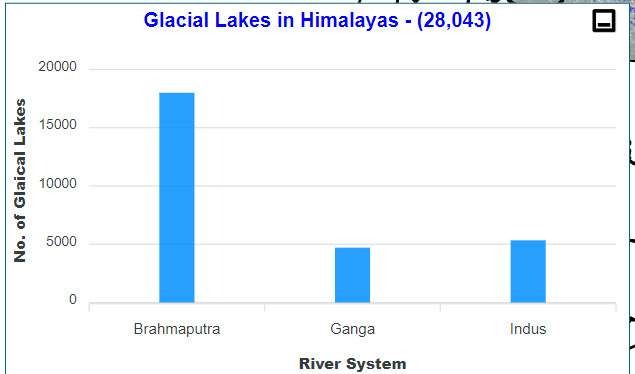
- Of the nearly 7,500 glacial lakes in the Indian Himalayas, NDMA has finalised 189 high-risk lakes that require mitigation measures.
What is the National Glacial Lake Outburst Floods Risk Mitigation Programme (NGRMP)?
- About: It is an initiative launched by the Government of India to address the risks posed by GLOFs.
- 16 teams went out for expedition out of which 15 teams completed their expedition. Another seven expeditions are underway.
- Of the 15 expeditions completed, 6 were in Sikkim, 6 in Ladakh, 1 in Himachal Pradesh, and 2 in Jammu and Kashmir.
- Teams on expeditions assess the structural stability and potential breach points of glacial lakes, gathering relevant hydrological and geological samples and data, measuring water quality and flow rates, identifying risk zones and making downstream communities aware.
- 16 teams went out for expedition out of which 15 teams completed their expedition. Another seven expeditions are underway.
- Objective:
- To assess hazards, install automated monitoring and early warning systems, and implement lake-lowering measures to mitigate glacial lake outburst flood (GLOF) risks.
- Lake-lowering measures are techniques used to reduce the volume of water in a glacial lake to mitigate the risk of a GLOF.
- NDMA is focussing on ground-truthing of selected 189 “high-risk” glacial lakes.
- Ground-truthing is the process of validating and verifying data collected through remote sensing or other indirect methods by comparing it with direct observations made on-site.
- To assess hazards, install automated monitoring and early warning systems, and implement lake-lowering measures to mitigate glacial lake outburst flood (GLOF) risks.
- Methodology to Prevent GLOF: Three activities are planned to be executed simultaneously.
- Placement of automated weather and water level monitoring stations and early warning systems
- Digital elevation modelling and bathymetry.
- Assessing best means to reduce the risk of that lake including by lake-lowering.
- Need of the Study:
- ICIMOD Findings: As per the International Centre for Integrated Mountain Development (ICIMOD), Hindu Kush Himalayas are experiencing rapid, irreversible changes due to climate change, increasing the risk of floods and landslides.
- Climate Change: Due to climate change, India faces hazards like extreme altered FDI (frequency, duration and intensity) of precipitation and extreme heat. It may lead to an increased number of flash floods.
- Previous Incidents of GLOFs:
- Nepal Incident: Recently, flash floods struck Thame, a village in the Khumbu region of Nepal which was due to an outburst flood from Thyanbo glacial lake.
- Sikkim Flash Flood: A catastrophic GLOF occured in South Lhonak Lake, Sikkim, in October 2023.
- Uttarakhand Flash Floods: A glacier breach-induced flood in February 2021 in Rishi Ganga valley resulted in over 200 deaths and significant damage to hydropower plants and Raini village.
GLOF
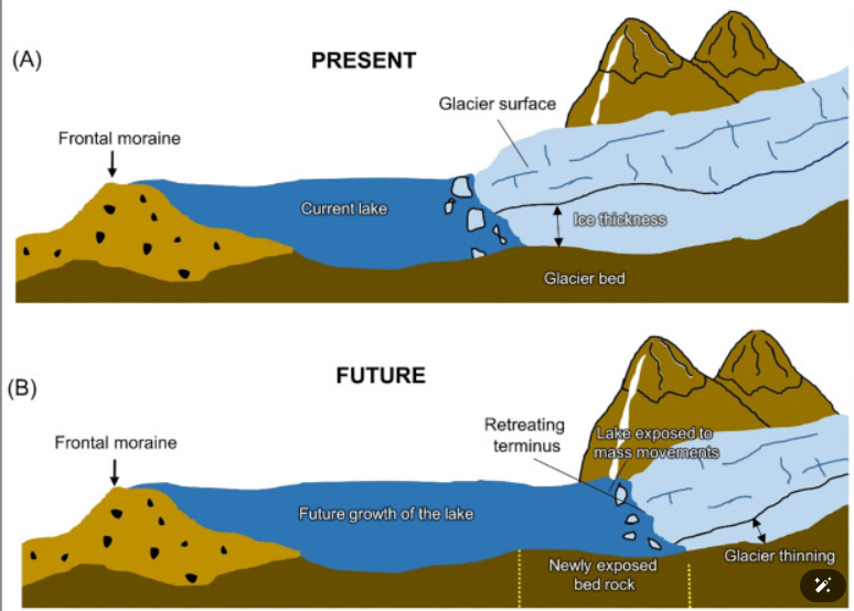
- A GLOF is a type of flood occurring when water dammed by a glacier or a moraine is released suddenly.
- When glaciers melt, the water in these glacial lakes accumulates behind loose naturally formed 'glacial/moraine dams' made of ice, sand, pebbles and ice residue.
- Unlike earthen dams, the weak structure of the moraine dam leads to the abrupt failure of the moraine dam on top of the glacial lake, which holds a large volume of water.
- A catastrophic failure of the dam can release the water over periods of minutes to days causing extreme downstream flooding.
What are the Recent Developments in NGRMP?
- About: The Arunachal Pradesh State Disaster Management Authority (APSDMA) to carry out a survey of high-risk glacial lakes in the Tawang and Dibang Valley districts of Arunachal Pradesh.
- It is part of the larger National Glacial Lake Outburst Flood (GLOF) Mission of the NDMA to map all glacial lakes in the country.
- High-Risk Glacial Lakes Identified in Arunachal Pradesh:
- Total High-Risk Lakes: 27 high-risk glacial lakes have been identified across five districts in Arunachal Pradesh.
- The lakes are located in Tawang (6 lakes), Kurung Kumey (1), Shi Yomi (1), Dibang Valley (16), and Anjaw (3).
- The current expedition teams will focus on three high-risk lakes in each of the Tawang and Dibang Valley districts.
- Total High-Risk Lakes: 27 high-risk glacial lakes have been identified across five districts in Arunachal Pradesh.
- Study Objectives: The team will study the accessibility, location, size, elevation, nearby habitations, and land use of the lakes at risk of GLOF.
- This will help the Centre for Development of Advanced Computing (C-DAC) and the Indian Meteorological Department install an Automatic Early Warning System and an Automatic Weather Station.
- Significance of the Study:
-
Strategic Location: Both Tawang and Dibang Valley districts share borders with China. It will be closely watched given its strategic location.
-
Fragile Himalayan Ecosystem: Landslides on the Chinese side, caused by China's interference with Himalayan geology and river systems, could also occur on the Indian side of the border.
-
Threat of Floods: In 2018, the Arunachal and Assam governments issued flood alerts after China reported a landslide blockage at the Yarlung Zangbo River.
- Heavy Infrastructure: The mega dam being built by China on the Yarlung Tsangpo river in Medog near the international border has been a constant worry over fear of adverse impact right from Arunachal to Assam.
-
|
Drishti Mains Question: Q. How Himalayas and glacial lakes are increasingly becoming vulnerable to climate change? What steps are being taken to mitigate risks like Glacial Lake Outburst Flood (GLOF)? |
UPSC Civil Services Examination, Previous Year Question (PYQ)
Prelims:
Q. Siachen Glacier is situated to the (2020)
(a) East of Aksai Chin
(b) East of Leh
(c) North of Gilgit
(d) North of Nubra Valley
Ans: (d)
Q. Consider the following pairs (2019)
Glacier - River
- Bandarpunch : Yamuna
- Bara Shigri : Chenab
- Milam : Mandakini
- Siachen : Nubra
- Zemu : Manas
Which of the pairs given above are correctly matched?
(a) 1, 2 and 4
(b) 1, 3 and 4
(c) 2 and 5
(d) 3 and 5
Ans: (a)
Q. Consider the following statements: (2010)
- On the planet Earth, the fresh water available for use amounts to about less than 1% of the total water found.
- Of the total fresh water found on the planet Earth 95% is bound up in polar ice caps and glaciers.
Which of the statements given above is/are correct?
(a) 1 only
(b) 2 only
(c) Both 1 and 2
(d) Neither 1 nor 2
Ans: (a)
Mains
Q. With reference to National Disaster Management Authority (NDMA) guidelines, discuss the measures to be adopted to mitigate the impact of the recent incidents of cloudburst in many places of Uttarakhand. (2016)


