Disaster Management
Flood Management in India
- 16 Jul 2024
- 17 min read
This editorial is based on “Behind Assam’s annual flood woes, a history of unintended consequences” which was published in The Indian Express on 16/07/2024. This article discusses how Assam’s geography, shaped by the Himalayas and monsoons, has led to chronic flooding, further highlighting the complex human-nature relationship in flood management.
For Prelims: Monsoon, Glacial Lake Outburst, Cyclone Michaung, Deforestation, Mullaperiyar Dam, Ken-Betwa Linking Project, Bhakra Nangal Dam, Central Water Commission (CWC), Comptroller and Auditor General (CAG), National Disaster Management Authority (NDMA), Pradhan Mantri Fasal Bima Yojana (PMFBY), MISHTI Initiative.
For Mains: Significance of Government Policies & Interventions in Holistic Disaster Management in India.
Recent floods in Assam highlight a recurring annual crisis in India, exacerbated by both natural and man-made factors. Floods are typically categorized as natural disasters by organizations like the National Institute of Disaster Management and the World Health Organisation. However, this classification overlooks the human factors contributing to flood damage.
Heavy monsoon rains significantly contribute to these floods, but poor disaster management and inadequate preparedness amplify their impacts. India’s geographical vulnerability results in severe losses each year, necessitating an Integrated Flood Management System.
With the monsoon accounting for 75% of annual rainfall, the country faces a dual challenge of floods and droughts. The monsoon every year follows this destructive pattern, reinforcing the urgent need for comprehensive flood risk mitigation strategies to safeguard lives and property.
What are the Causes of Floods in India?
- Natural Causes:
- Heavy Rainfall: The primary cause of floods in India is heavy rainfall, especially during the monsoon season from June to September.
- Intense and erratic rainfall can exceed the soil's absorption capacity or overwhelm drainage systems, leading to floods.
- Melting of Glaciers: Melting snow and glaciers in mountainous regions due to rising temperatures can increase river and stream water levels, resulting in downstream flooding.
- For example: Glacial lake outburst flood killed around 14 in Sikkim more than hundred people were missing.
- Cyclones and Storms: Cyclones and storms can generate strong winds and heavy rainfall, particularly affecting coastal regions.
- For instance, Cyclone Michaung in December 2023 caused intense rain and flooding that killed around 13 people.
- River Overflow: Flooding can occur when a river's water level exceeds its capacity due to excessive inflow from upstream or diminished outflow downstream.
- In 2023, the Yamuna River overflowed due to heavy rains in Himachal Pradesh and Haryana, overwhelming the barrages in Delhi and causing flooding in several areas along the river.
- Heavy Rainfall: The primary cause of floods in India is heavy rainfall, especially during the monsoon season from June to September.
- Man Made Causes:
- Unplanned & Rapid Urbanisation: Unplanned urbanisation and shooting up of slums on the outskirt of urban centres add to flood havoc in case of heavy rainfall.
- The 2020 floods in Hyderabad and Chennai in 2015, thousands of houses were submerged, reminding of how rapid urbanisation is making cities prone to urban floods.
- Another fine example is Gurugram which has a persistent problem that haunts it every monsoon season – severe flooding.
- Concretisation: The rapid concretisation due to use of asphalt and concrete has increased impervious surfaces that do not absorb rainwater, leading to increased surface runoff.
- As a result, during heavy rainfall, water accumulates quickly, overwhelming drainage systems and contributing to localized flooding.
- Encroachment of Water Resources: Construction and development activities in riverbeds and floodplains can severely disrupt the natural flow of rivers and encroachment of lakes and ponds.
- For example, encroachment activities in lakes of urban centers like Bhopal and Chennai have increased flooding instances in these cities.
- Deforestation:Forests play a crucial role in absorbing rainfall and facilitating ground water recharge.
- Deforestation leads to reduced soil's capacity to retain water, leading to greater surface runoff which carry excess water into rivers and streams, raising the risk of flooding.
- Dams and Barrages: Dams and barrages are built to manage water flow and generate hydroelectric power, but heavy rain and poorly managed reservoirs can pose significant risks.
- For instance, alleged poor management of water in Mullaperiyar dam in Tamilnadu and Kerala border area caused floods in 2018.
- Unsustainable Mining Practices: Mining operations can disrupt the landscape, leading to soil erosion and sedimentation in nearby rivers.
- This sediment accumulation reduces the carrying capacity of rivers, while mining activities can alter natural drainage patterns, increasing the risk of water accumulation.
- Climate Change: Human activities that contribute to climate change are altering weather patterns worldwide. Increased temperatures can lead to more intense and unpredictable rainfall, raising the potential for flooding events.
- Poor Drainage Systems: In many urban and rural areas, due to siltation and clogging by solid waste, drainage infrastructure is inadequate to handle heavy rainfall.
- Poorly designed or maintained drainage systems can cause significant flooding, even during moderate rain events.
- For Example: Improper urban planning and ineffective drainage solutions lead to waterlogging in cities like Delhi.
- Unplanned & Rapid Urbanisation: Unplanned urbanisation and shooting up of slums on the outskirt of urban centres add to flood havoc in case of heavy rainfall.
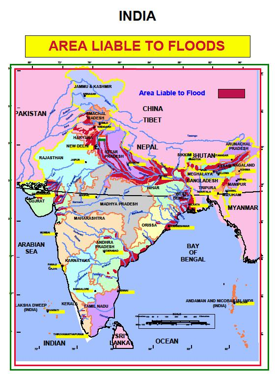
How Vulnerable is India to Floods?
- According to the National Disaster Management Authority (NDMA), regions susceptible to floods lie mostly along the Ganga-Brahmaputra river basin, from the northern states of Himachal Pradesh and Punjab, covering Uttar Pradesh and Bihar and stretching to Assam and Arunachal Pradesh in the northeast.
- The coastal states of Odisha and Andhra Pradesh, parts of Telangana and Gujarat also witness yearly floods.
- Old Estimation:
- The current demarcation is based on estimates made in 1980 by Rashtriya Barh Ayog (RBA) or National Flood Commission formed four decades ago.
- Around 12.19% of geographical area in India is vulnerable to floods, according to the RBA.
- Climate Change:
- Over the last four decades, India has been reeling from the effects of climate change.
- Extreme rainfall events have tripled in central India between 1950 and 2015, according to the science journal Nature.
- According to Climate Change and India report by the Union Ministry of Environment and Forest, there will be a rise in the frequency of floods in India due to rising temperatures between 2070 and 2100,
- Increased Downpour:
- In recent times, the southwest monsoon period has also been causing massing floods in parts of the country in recent years.
- In 2020, 256 districts across 13 states in India reported floods due to excess rainfall.
What is the Role of Dams and Embankments in Flood Management?
- Role of Dams in Flood Management:
- While dams are often seen as a solution to control river flooding, they can also contribute to flood disasters under certain conditions.
- As per a report by the Comptroller and Auditor General (CAG) only 7% of dams have Emergency Action Plans, highlighting a significant gap in disaster management readiness
- Inadequate Management: Dams may be filled to capacity without considering flood risks, leading to the need for sudden water releases that can exacerbate downstream flooding.
- Impact of Poor Operations: If dams are not operated with flood moderation as a priority, they can inadvertently increase flood severity in downstream areas.
- Examples: Several floods in India like Uttarakhand (June 2013), Chennai (December 2015) and Kerala Floods (2018) have been linked to improper dam management, on other hand various dam projects in the Brahmaputra Basin have contributed to increased flood risks across the region.
- Role of Embankments in Flood Management:
- In several states like Bihar and Assam, flood mitigation policies primarily rely on building embankments.
- Increased Flood Intensity: The rising intensity of floods has rendered these embankments largely ineffective.
- Lack of Analysis: No comprehensive cost-benefit analysis has been conducted to evaluate the effectiveness of embankments.
- False Security: Communities near embankments live in fear of breaches, while those inside face flash floods and other flood types.
- Exacerbated Flooding: Breaches cause more severe flooding than natural river floods, resulting in destructive water cascades.
- Silt and Debris Accumulation: Embankments contribute to the build-up of silt and debris in riverbeds, raising water levels and increasing the risk of breaches.
- Changes in River Dynamics: The construction of embankments alters river flow patterns, leading to severe flooding during breaches.
- Experts on embankment:
- G R Garg committee (1951) noted that while embankments might be beneficial for stable rivers with low silt levels, they could cause more harm than good in rivers that carry significant silt, as this could disrupt natural land-building processes and drainage systems.
- The National Flood Commission (1976-1980) concluded that embankments in Assam had exacerbated flooding issues by causing the deposition of coarse silt and sand in riverbeds. As a result, riverbeds rose above surrounding land, creating a precarious situation that would lead to severe devastation if the embankments were breached.
What are Solutions for Flood Management in India?
Structural Measures
- The InterLinking of Rivers programme (ILR) programme:
- It is aimed at linking different surplus rivers of the country with deficient rivers so that the excess water from surplus regions could be diverted to deficient regions.
- For instance: Ken-Betwa linking project is the flagship project of the national government and is crucial for the water security and socio-economic development of Bundelkhand region.
- Reservoirs:
- Storage reservoirs are artificial structures designed to store excess water during high-flow periods and release it during low-flow periods.
- They moderate flood peaks by reducing water volume and velocity downstream; conserves water for irrigation, power generation, and supply.
- Example: Bhakra Nangal Dam on the Sutlej River has a storage capacity of about 9621 Million Cubic Meter (MCM), aiding in flood control, power generation, and irrigation.
- Managing Coastal Flood:
- The 2004 Tsunami made people realize that mangroves can serve as a reliable safety hedge against coastal calamities like storm surge and coastal flooding.
- MISHTI Initiative for mangroves plantation was launched in the Union Budget 2023-24.
- Embankments:
- Embankments are raised structures that confine water flow within channels or along riverbanks.
- They protect adjacent areas from flooding; increase river carrying capacity; divert excess water; provide access roads and recreational areas.
- Diversions:
- Diversions are structures that redirect water flow from one channel to another and they reduce flooding by transferring excess water to less vulnerable areas or reservoirs; providing irrigation or drinking water to other regions.
- Example: Indira Gandhi Canal project diverts water from Sutlej and Beas rivers to the Thar desert in Rajasthan for irrigation and drinking.
Non-structural Measures:
- Flood Forecasting and Early Warning: Systems that provide early estimates of approaching floods using meteorological and hydrological data.
- They facilitate timely evacuation of people and assets; assists in reservoir management and flood relief coordination.
- Example: Central Water Commission (CWC) operates a network of forecasting stations that issue daily flood alerts.
- Flood Plain Zoning: It is regulatory measures that control land use in flood-prone areas based on vulnerability and promotes conservation of natural flood buffers like wetlands and forests.
- Example: National Disaster Management Authority (NDMA) guidelines classify flood-prone land into four zones: prohibited, restricted, regulated, and free.
- Flood Insurance: It is in the form of financial compensation for flood-related losses to individuals or groups who pay a premium which may reduce government relief burdens; encourages risk reduction measures; creates a database for flood risk assessment.
- Example: Pradhan Mantri Fasal Bima Yojana (PMFBY) provides crop insurance for losses due to floods and other calamities.
- Flood Awareness: Flood awareness and education initiatives to raise awareness preparedness and response capabilities; fosters a culture of safety and resilience among communities.
- Example: NDMA conducts awareness campaigns and training programs focused on flood management in India.
Conclusion
To effectively tackle flooding, it is vital to recognize that both natural and man-made factors contribute to this ongoing crisis. While natural causes are unavoidable, human actions like urban encroachment and poor infrastructure management, which significantly worsen the impact, can be managed. By adopting a holistic strategy that incorporates advanced forecasting, sustainable practices, and community awareness, we can better prepare for and respond to flooding challenges.
|
Drishti Mains Question: Q. Discuss the major causes of flooding in India, differentiating between natural and man-made factors. Assessing the effectiveness of existing flood management strategies, suggest comprehensive solutions to enhance flood resilience in vulnerable regions of the country. |
UPSC Civil Services Examination, Previous Years Questions (PYQs)
Prelims:
Q. La Nina is suspected to have caused recent floods in Australia. How is La Nina different from El Nino? (2011)
1. La Nina is characterised by an usually cold ocean temperature in equatorial Indian Ocean whereas El Nino is characterised by unusually warm ocean temperature in the equatorial Pacific Ocean.
2. El Nino has adverse effect on south-west monsoon of India but La Nina has no effect on monsoon climate.
Which of the statements given above is/are correct?
(a) 1 only
(b) 2 only
(c) Both 1 and 2
(d) Neither 1 nor 2
Ans: (d)
Mains:
Q. The interlinking of rivers can provide viable solutions to the multi-dimensional inter-related problems of droughts, floods, and interrupted navigation. Critically examine. (2020)
Q. Account for the huge flooding of million cities in India including the smart ones like Hyderabad and Pune. Suggest lasting remedial measures. (2020)


-min.jpg)