Landslide and Preventive Measures | 14 Jan 2025
For Prelims: Landslides, Soil Moisture, Western Ghats, Convective Rainfall, Earthquakes, Volcanic Activity, North East Himalaya, North West Himalaya, Eastern Ghats, Deforestation, NDMA, NRSC, ISRO, Ecologically Sensitive Areas (ESA), Western Ghats Ecology Authority (WGEA), Environment (Protection) Act, 1986, Hydropower Projects, Geotextiles, LiDAR.
For Mains: Landslides: their causes and impacts, Potential measures to mitigate and major initiatives already taken.
Why in News?
A study published in Nature Natural Hazards on the July 2024 Wayanad landslides emphasizes the need for better disaster management strategies in vulnerable areas.
- In July 2024, Wayanad district in Kerala experienced a devastating landslide disaster caused by extreme rainfall and fragile ecological conditions.
What are the Key Facts Regarding the Study?
- About: The study aimed to understand the behavior of rapid debris flows and improve disaster management strategies in vulnerable areas like Wayanad, Kerala.
- Research Methodology: The study used advanced run-out modelling and Rapid Mass Movement Simulation (RAMMS) to track debris flow paths, speed, pressure, and material accumulation during landslides.
- Runout analyses are used to assess risks and design measures against rapid landslides, including debris flows, rockslide avalanches, and failures of fill and mining waste.
- RAMMS evaluates natural hazard processes and assesses protective measures through a user-friendly graphical interface.
- Key Findings:
- Debris Accumulation: Significant debris accumulation was observed at lower elevations of slope, creating future hazards downstream.
- Vulnerability Mapping: Detailed vulnerability maps, including run-out paths, are crucial for identifying high-risk zones and preventing development in low lying areas to minimize destruction and loss of life.
- Historical Context: The path of the 2024 debris flow at Wayanad mirrored previous events, including a deadly landslide in 1984 and a smaller one in 2019.
- Early Warning Systems: The study emphasizes the need for rainfall and soil moisture monitoring stations to set early warning thresholds, enabling timely alerts for evacuations and safety measures to save lives.
Wayanad Landslides
- Wayanad's terrain consists of a soil layer over hard rocks. Intense rainfall saturates the soil, weakening its bond with the rocks and causing landslides.
- The recent warming of the Arabian Sea has led to deep cloud systems and extremely heavy rainfall in the Western Ghats, heightening landslide risks.
- Climate change has also shifted the rain-bearing belt, leading to more convective rainfall in southern regions like Wayanad.
- Convectional rainfall occurs when heated air rises with water vapor, condenses at higher altitudes, and releases rainfall in the same area without being carried away by wind.
What are Landslides?
- About: A landslide is the downward movement of rock, soil, and debris on a slope, triggered by factors such as heavy rainfall, earthquakes, volcanic activity, human activities, and groundwater changes.
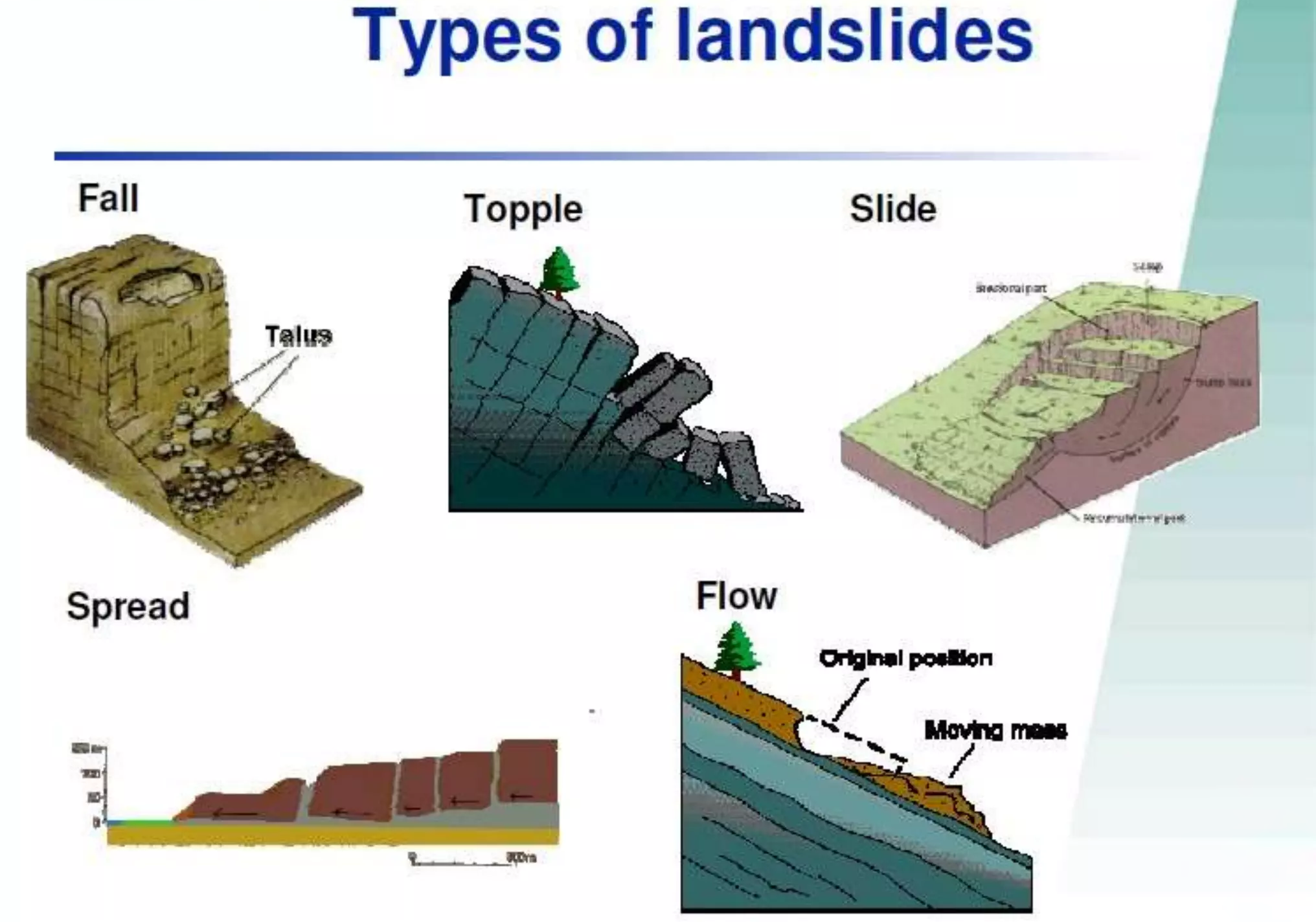
- Types:
- Slides: Movement along a rupture surface, including rotational and translational slides.
- Flows: Soil or rock mixed with water moving like a fluid, such as earth flows, debris flows, mudflows, and creep.
- Spreads: Lateral extension and cracking of the mass, often due to liquefaction.
- Topples: Forward rotation and free-fall from a vertical or near-vertical slope.
- Falls: Detachment from a steep slope or cliff, descending by free-fall, bouncing, or rolling.
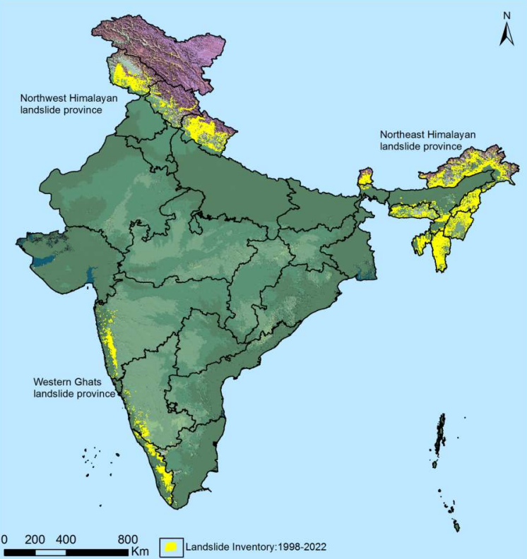
- Landslide Prone Areas: As per the Landslide Atlas of India, around 0.42 million sq. km (12.6% of land area) is prone to landslides, with 0.18 million sq. km in the North East Himalaya, 0.14 million sq. km in the North West Himalaya, 0.09 million sq. km in the Western Ghats and Konkan hills, and 0.01 million sq. km in the Eastern Ghats of Andhra Pradesh.
- Causes:
- Gravitational Forces: When gravity overcomes the strength of materials like rocks, sand, silt, and clay, the slope collapses, causing these materials to move downhill.
- Natural Factors:
- Rainfall: Heavy or continuous rainfall increases soil moisture, weakens cohesion, and adds weight to slopes, making them more likely to fail.
- Earthquakes: Earthquakes destabilize slopes by shaking the ground and weakening geomaterials, particularly in tectonically active regions like the Himalayas.
- Hydrological Factors: Water seepage through porous materials raises pore pressure and weakens the slope.
- Anthropogenic Factors: Deforestation destabilizes slopes by removing vegetation and tree roots that provide reinforcement and water drainage.
- Mining, road construction, and urban development disrupt natural drainage and load distribution, raising landslide risks.
- Geological Factors: Geological factors like material composition, structure, and weathering affect slope stability.
- The Western Ghats' steep, dual-layered terrain makes them prone to landslides when rainwater saturates the soil, increasing weight and reducing stability.
How are Landslides in Himalayan Region Different from Landslides in Western Ghats?
|
Cause |
Himalayas |
Western Ghats |
|
Slope and Terrain |
Steep, rugged terrain with high-altitude, unstable slopes. |
Less steep and more gradual slopes, reducing landslide risk. |
|
Tectonic Activity |
Highly tectonically active region due to the collision of the Indian and Eurasian plates, triggering earthquakes. |
Less tectonic activity, with minimal earthquake-triggered landslides. |
|
Rainfall and Snowmelt |
Heavy monsoon rainfall combined with rapid snowmelt from glaciers, increasing soil saturation and instability. |
Heavy rainfall during monsoon, but no snowmelt, reducing landslide triggers. |
|
Soil and Rock Composition |
Unconsolidated debris (scree, moraine) and fragile rock formations prone to displacement. |
More stable soil and rock types, reducing landslide occurrences. |
|
Deforestation |
High rates of deforestation for agriculture, timber, and fuel, weakening soil cohesion. |
Less deforestation compared to the Himalayas, although still a concern. |
What are the Impacts of Landslides?
- Human Life and Safety: Fast-moving landslides are particularly deadly, and slow-moving landslides, though less deadly, can still cause significant damage to property over time.
- Damage to Infrastructure: Roads, rail lines, pipelines, and communication lines can be blocked or severely damaged, disrupting essential services.
- Landslides can bury homes, leading to loss of life and property.
- Cascading Effects: A landslide can block streams, forming a debris dam. If the dam bursts, it can cause downstream flooding, further increasing damage.
- Economic Loss: Repairing damaged infrastructure and providing humanitarian aid can be costly. Landslides also disrupt local economies, especially in agriculture and tourism-dependent areas.
- Environmental Impact: Landslides disrupt ecosystems, affecting soil stability and vegetation, which can exacerbate erosion and soil degradation.
What are the Government Initiatives to Mitigate Landslide Risks in India?
- National Landslide Risk Management Strategy (2019): It is a comprehensive approach that includes hazard mapping, monitoring, early warning, awareness, capacity building, policies, and stabilisation.
- Landslide Risk Mitigation Scheme (LRMS): It aims to provide financial support for landslide mitigation in vulnerable states, focusing on prevention, mitigation, and research on critical landslides.
- Flood Risk Mitigation Scheme (FRMS): The scheme includes pilot projects for multi-purpose flood shelters and flood early warning systems with digital maps to alert villagers for evacuation.
- National Guidelines on Landslides and Snow Avalanches: NDMA guidelines cover hazard assessment, risk management, structural and non-structural measures, institutional mechanisms, financial arrangements, and community involvement.
- Landslide Atlas of India: Created by NRSC under ISRO, it records landslide events in vulnerable areas, featuring damage assessments and offering valuable insights on landslides in India.
Committees to Conserve Landslide Prone Western Ghats
- Western Ghats Ecology Expert Panel, 2011 (Headed by Madhav Gadgil): The entire Western Ghats should be declared Ecologically Sensitive Areas (ESA) with restricted development in graded zones.
- Classify the Western Ghats into ESA 1, 2 and 3 with ESA-1 having a high priority where almost all developmental activities are restricted.
- Western Ghats Ecology Authority (WGEA) to be constituted as a statutory authority under the Ministry of Environment, Forest and Climate Change, under the Environment (Protection) Act, 1986.
- The report was criticised for being more environment-friendly and not in tune with the ground realities.
- Kasturirangan Committee, 2013: Instead of the total area of Western Ghats, only 37% of the total area to be brought under ESA.
- Complete ban on mining, quarrying, and sand mining in ESAs, with no thermal power projects allowed and hydropower projects permitted only after a detailed study.
What Measures can be Taken to Prevent Landslides Hazards?
- Engineering Solutions:
- Slope Stabilization: Uses retaining walls, rock bolts, soil nails, and ground anchors to prevent soil and rock movement.
- Combine plants with engineering methods, such as brush layering and live crib walls, to stabilize slopes using natural elements.
- Grading and Terracing: Modifying the slope and gradient can reduce instability, while terracing creates level surfaces on steep areas.
- Drainage Systems: Installs channels, pipes, or culverts to control water flow, reducing pore pressure and maintaining soil strength.
- Soil Reinforcement: Uses geotechnical materials like geotextiles and geogrids to reinforce slopes, enhancing stability and preventing landslides.
- Slope Stabilization: Uses retaining walls, rock bolts, soil nails, and ground anchors to prevent soil and rock movement.
- Natural Solutions:
- Vegetation Control: Planting trees, shrubs, and grasses binds soil, absorbs excess water, reduces erosion, and intercepts rainfall to lower landslide risks.
- Organic or inorganic mulch retains soil moisture, prevents erosion, and stabilizes slopes by reducing rainfall impact.
- Water Management: Techniques like contouring, and rain gardens slow water runoff, encourage infiltration, and reduce slope instability.
- Vegetation Control: Planting trees, shrubs, and grasses binds soil, absorbs excess water, reduces erosion, and intercepts rainfall to lower landslide risks.
- Early Warning Systems: Install instruments like inclinometers to measure slope stability and provide early warnings.
- Monitoring rainfall intensity and cumulative rainfall helps identify landslide triggers.
- Technologies like LiDAR and satellite imagery detect ground movements and surface changes signaling potential landslides.
- Best Land Use Practices: Avoiding altering slopes, limiting impervious surfaces, designing proper drainage systems, and implementing erosion control measures are crucial to stabilize slopes and reduce runoff.
Conclusion
There is an urgent need for improved disaster management strategies to mitigate landslide risks in vulnerable areas like Wayanad. Engineering solutions, natural methods, early warning systems, and effective land use practices are essential to reduce landslide hazards and enhance resilience against climate change-induced rainfall extremes.
|
Drishti Mains Question: Discuss the causes and impacts of landslides in India. How can disaster management strategies be improved? |
UPSC Civil Services Examination, Previous Year Questions (PYQs)
Mains:
Q. Differentiate the causes of landslides in the Himalayan region and Western Ghats. (2021)
Q. The Himalayas are highly prone to landslides.” Discuss the causes and suggest suitable measures of mitigation. (2016)


