Disaster Management
Landslides in Wayanad
- 01 Aug 2024
- 18 min read
For Prelims: Landslide and its types, National Landslide Risk Management Strategy, Landslide Risk Mitigation Scheme (LRMS), Flood Risk Mitigation Scheme (FRMS), National Guidelines on Landslides and Snow Avalanches, Landslide Atlas of India, Geological Survey of India
For Mains: Landslides: their causes, difference between landslides in himalayas and Western Ghats, Potential measures to mitigate and major initiatives already taken.
Why in News?
Recently, the Wayanad district of Kerala has witnessed one of the most devastating landslide-related disasters due to extreme rainfall and fragile ecological conditions.
- The district received over 140 mm of rain in 24 hours, surpassing expectations and recalling the devastating 2018 floods that claimed around 500 lives.
Note:
- The central government has planned to introduce the Disaster Management (Amendment) Bill, 2024 in the 18th Lok Sabha.
- The Bill seeks to create a disaster database at national and State level and makes provision for the constitution of Urban Disaster Management Authority for State capitals and large cities having Municipal Corporations.
- The database will include disaster assessment, fund allocation details, expenditure, preparedness and mitigation plan, risk register according to type and severity of risk and such other relevant matters.
What are Landslides?
- About:
-
A landslide is the downward movement of rock, soil, and debris on a slope, ranging from small shifts to large, destructive events.
-
It can occur on natural or man-made slopes and is triggered by factors like heavy rainfall, earthquakes, volcanic activity, human activities, and changes in groundwater levels.
-
-
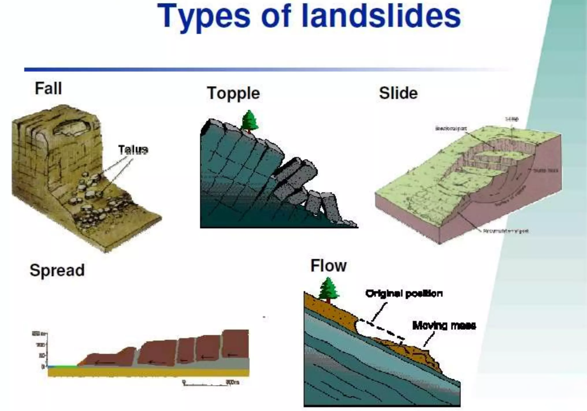
Types:
- Slides: Movement along a rupture surface, including rotational and translational slides.
- Flows: Soil or rock mixed with water moving like a fluid, such as earth flows, debris flows, mudflows, and creep.
- Spreads: Lateral extension and cracking of the mass, often due to liquefaction.
- Topples: Forward rotation and free-fall from a vertical or near-vertical slope.
- Falls: Detachment from a steep slope or cliff, descending by free-fall, bouncing, or rolling.
- The Landslide Atlas of India by ISRO:
- India is among the top 5 landslide-prone countries globally.
- Others are China, US, Italy and Switzerland.
- In India, about 0.42 million sq. km (12.6% of land area) is prone to landslide hazard.
- Reported landslides in India are distributed as follows:
- 66.5% in the Northwestern Himalayas
- 18.8% in the Northeastern Himalayas
- 14.7% in the Western Ghats
- As per the Geological Survey of India, the economic loss due to landslides may amount to as much as 1% to 2% of the Gross National Product (GNP) in many developing countries
- India is among the top 5 landslide-prone countries globally.
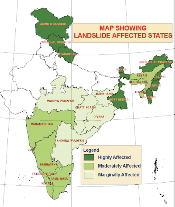
- Major Landslide-Prone Areas in India:
- The Northeastern Region (comprising about 50% of the total landslide-prone areas)
- Uttarakhand, Himachal Pradesh, and Jammu & Kashmir along the Himalayas.
- Maharashtra, Goa, Karnataka, Kerala, and Tamil Nadu along the Western Ghats
- The Araku region in Andhra Pradesh along the Eastern Ghats.
- Nearly 17,000 sq km of area in Kerala, mostly on the western side of the Western Ghats, is mapped as landslide-prone.
Major Landslides in India
- Kedarnath, Uttarakhand in 2013
- Pettimudi, Kerala in 2020
- Mumbai, Maharashtra in 2021
- Tupal, Manipur in 2022
- Raigarh, Maharashtra in 2023
- Aizawl, Mizoram in 2024
- Shirur, Karnataka in 2024
What are the Causes of Landslides?
- Gravitational Forces: These are the primary cause of landslides, constantly pulling materials on slopes downward.
- When gravity exceeds the shear strength of geomaterials like rocks, sand, silt, and clay, the slope fails, resulting in the downhill movement of these materials.
- Natural Triggers:
- Rainfall: Prolonged or intense rainfall increases soil water content, reducing cohesion and adding weight to slopes, making them more prone to failure.
- The terrain in Wayanad has two distinctive layers: a soil layer atop hard rocks. Heavy rainfall saturates the soil with moisture, weakening the force binding the soil to the rocks, triggering landslides.
- Aslo, the recent warming of the Arabian Sea has led to deep cloud systems and extremely heavy rainfall in the Western Ghats, heightening landslide risks. Climate change has also shifted the rain-bearing belt, increasing convective rainfall in southern regions like Wayanad.
- Convectional rainfall occurs when heated air from the earth's surface rises upwards with water vapour, condensing at higher altitudes. The clouds carrying the water vapour are not carried away by wind, resulting in rainfall at the same place.
- Earthquakes: Earthquakes destabilise slopes by shaking the ground and weakening the structural integrity of geomaterials, especially in tectonically active regions like the Himalayas.
- Erosion: Natural processes such as river or wave action can erode the base of slopes, undermining their stability. Coastal areas are particularly susceptible to landslides due to wave-induced erosion.
- Rainfall: Prolonged or intense rainfall increases soil water content, reducing cohesion and adding weight to slopes, making them more prone to failure.
- Hydrological Factors: Groundwater movement can contribute to landslide risk. Water can seep through porous materials, increasing pore pressure and reducing effective stress, thereby weakening the slope.
- Anthropogenic Influences:
-
Deforestation: This has removed vegetation, destabilising slopes by eliminating tree roots that provide natural reinforcement and water drainage.
- Construction and Land Use Changes: Activities such as mining, road construction, and urban development have disrupted natural drainage and load distribution, increasing landslide risks.
- Also, historical deforestation for agriculture and tea plantations by Britishers has weakened soil stability, making the region (western ghats) more prone to landslides during heavy rains.
- Infrastructure Development: Tourism and infrastructure development, including resorts, artificial lakes, and construction activities, have intensified land pressure and disrupted natural drainage, increasing landslide risks.
-
- Geological Factors: Geological factors, such as the composition, structure, and weathering state of materials, significantly affect slope stability.
- The Western Ghats have a fragile ecology with steep slopes and dual-layered terrain, making them prone to landslides when rainwater saturates the soil, increasing its weight and reducing stability.
- Defunct Quarries: The presence of quarries in the vicinity, even after they have ceased operations have also contributed to soil destabilisation as the vibrations and shockwaves from these activities could weaken the geological structure, making the area more prone to landslides during heavy rains.
How do Landslides in the Western Ghats Differ from Those in the Himalayan Region?
| Region | Causes |
| Western Ghats |
|
| Himalayas |
|
What are the Challenges Associated with Landslides?
- Loss of Life and Injury: Landslides can result in fatalities and serious injuries to individuals in affected areas. The sudden nature of landslides often leaves little time for evacuation.
- Displacement of Communities: Landslides can lead to the displacement of populations, forcing communities to relocate. This can disrupt social structures and lead to long-term socio-economic challenges.
- Damage to Infrastructure: Critical infrastructure such as roads, bridges, and buildings can be severely damaged or destroyed, leading to significant economic losses and hampering rescue and relief operations.
- Economic Impact: The cost of repairing damaged infrastructure and providing humanitarian aid can be substantial. Additionally, landslides can disrupt local economies, particularly in areas reliant on agriculture and tourism.
- Environmental Degradation: Landslides can lead to soil erosion, loss of vegetation, and habitat destruction, adversely affecting biodiversity and ecosystem services.
Why is Predicting Landslides Difficult?
- Complexity of Geomaterials: The subsurface consists of various rocks and particulate materials with differing strengths, making it difficult to assess stability accurately.
- Insufficient Data: Detailed three-dimensional mapping of geomaterials is required, but current technology often relies on limited data from select locations, leading to uncertainty.
- Identifying Weak Points: Critical weak points, such as fractures in rock masses, can be easily overlooked, contributing to prediction inaccuracies.
- Estimating Size and Runout: Determining the exact size of a potential landslide and its runout distance is challenging, complicating risk assessments.
- Timing Predictions: Forecasting when landslides will occur is difficult, akin to predicting weather or seismic activity, which involves inherent uncertainties.
- Environmental Variability: Changes in rainfall patterns, seismic activity, and human activities can all influence slope stability, adding further complexity to predictions.
- Technological Limitations: Current sensors and models may not provide the necessary precision for accurate predictions, especially in remote or inaccessible areas.
What are the Government Initiatives to Mitigate Landslide Risks in India?
- National Landslide Risk Management Strategy (2019): It is a comprehensive strategy addressing hazard mapping, monitoring, early warning systems, awareness programs, capacity building, policies, and stabilisation measures.
- Landslide Risk Mitigation Scheme (LRMS): This scheme under preparation, aims to provide financial support for tailored landslide mitigation projects in vulnerable states, focusing on disaster prevention, mitigation strategies, and research and development for monitoring critical landslides.
- This initiative will contribute to the establishment of an Early Warning System (EWS) and enhance capacity-building efforts.
- Flood Risk Mitigation Scheme (FRMS): A forthcoming scheme for developing flood shelters, river basin-specific early warning systems, and digital elevation maps for flood preparedness and evacuation.
- National Guidelines on Landslides and Snow Avalanches: Guidelines by National Disaster Management Authority (NDMA) covering hazard assessment, risk management, structural and non-structural measures, institutional mechanisms, financial arrangements, and community participation.
- Landslide Atlas of India: It is a detailed resource that documents landslide events in the country's vulnerable areas and includes damage assessments for certain sites. Developed by the National Remote Sensing Centre (NRSC) under Indian Space Research Organisation (ISRO), it offers important information and insights related to landslides in India.
What are the Recommendations of Various Committees on Western Ghats?
- Western Ghats Ecology Expert Panel, 2011 (Headed by Madhav Gadgil):
- All of the Western Ghats be declared as Ecologically Sensitive Areas (ESA)
- with only limited development allowed in graded zones.
- Classify the Western Ghats into ESA 1, 2 and 3 with ESA-1 having a high priority where almost all developmental activities are restricted.
- Specified the system of governance to be a bottom-to-top approach (right from Gram sabhas) rather than a top-to-bottom approach.
- Western Ghats Ecology Authority (WGEA) to be constituted as a statutory authority under the Ministry of Environment, Forest and Climate Change, with the powers under Section 3 of the Environment (Protection) Act, 1986.
- The report was criticised for being more environment-friendly and not in tune with the ground realities.
- Kasturirangan Committee, 2013: It sought to balance the development and environmental protection in contrast to the Gadgil report:
- Instead of the total area of Western Ghats, only 37% of the total area to be brought under ESA.
- Complete ban on mining, quarrying and sand mining in ESAs.
- No thermal power projects to be allowed and hydropower projects be allowed only after detailed study.
- Red industries i.e. which are highly polluting to be strictly banned.
- Exclusion of inhabited regions and plantations from the purview of ESAs making it a pro-farmer approach.
What Measures can be Taken to Prevent Landslides Hazards?
- Building Resilience: This involves setting up a network of sensors for real-time monitoring and data collection.
- Assessment of rainfall thresholds for soil saturation in different areas.
- Mapping out the routes that landslides are likely to take after being triggered.
- Creating route maps to mark areas that should be out of bounds for settlements or activities.
- Harnessing Technology for Vigilant Monitoring: Utilise web-based sensors like rain gauges, piezometers, inclinometers, extensometers, InSAR (Interferometric Synthetic Aperture Radar), and total stations to monitor vulnerable areas, focusing on densely populated and urbanised zones.
- Integrated EWS: Develop a comprehensive EWS using Artificial Intelligence (AI) and Machine Learning (ML) algorithms to predict and alert communities about impending hazards, providing valuable time for precautionary measures.
- Sustainable Socio-Economic Progress: Recognise the region's valuable natural resources, such as glaciers, springs, minerals, energy sources, and medicinal plants, for sustainable socio-economic development. Balance resource utilisation with ecological conservation for long-term viability.
- Environmental Considerations: There is a need to safeguard ecosystems through sustainable practices and responsible resource use.
- Implement thoughtful urban planning in mountainous areas, restricting extensive construction and managing drainage and slope excavation scientifically.
- Use retaining walls to support soil and restore ecological balance through reforestation and soil conservation efforts.
- Building Codes and Evaluation: There is a need to map towns and assess load-bearing capacities to develop robust building codes for safe construction in hazard-prone areas. Enforce strict land use restrictions in these areas to prevent activities that could destabilise the soil.
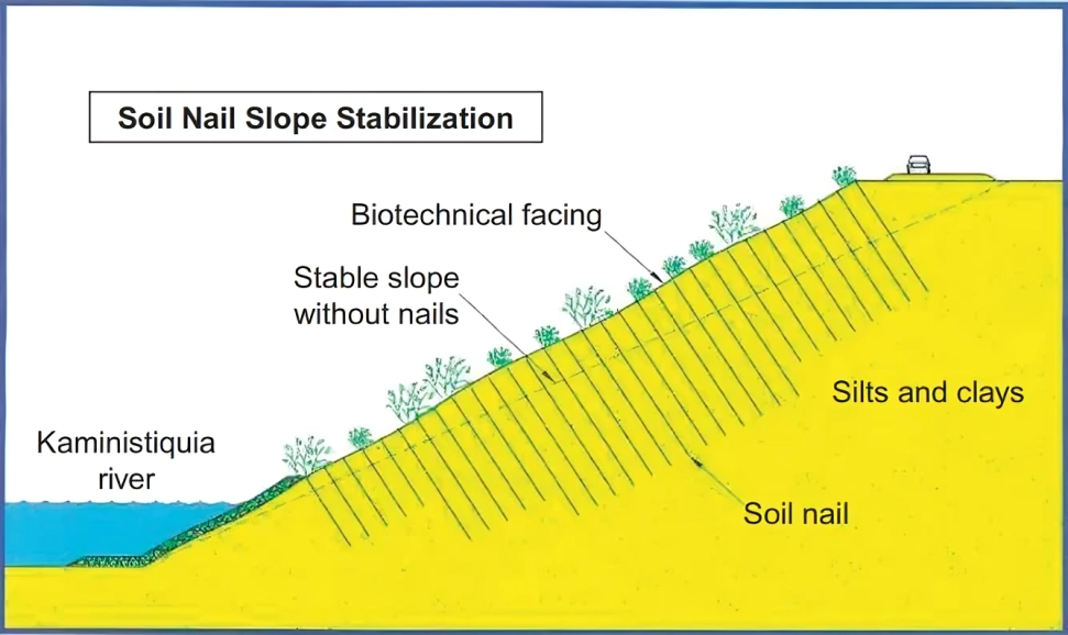
Soil Nailing and Hydroseeding for Landslide Prevention
- The State highways department in Kerala is tackling landslide issues in the Nilgiris with soil nailing and hydroseeding.
- Soil nailing reinforces soil, while hydroseeding promotes plant growth with a mix of seeds, fertiliser, and water.
- This approach includes planting five grass species and maintaining the vegetation to reduce the environmental impact of road infrastructure.
Conclusion
The Wayanad landslides serve as a stark reminder of the interplay between natural disasters and human activities. A multifaceted approach involving regulation, education, and scientific research is essential to mitigate the risks and protect vulnerable communities in the future.
|
Drishti Mains Question: Q. What are the causes of frequent landslides in Western Ghats? What are the mitigation strategies that could be adopted? |
UPSC Civil Services Examination, Previous Year Questions (PYQs)
Mains:
Q. Differentiate the causes of landslides in the Himalayan region and Western Ghats. (2021)
Q. The Himalayas are highly prone to landslides.” Discuss the causes and suggest suitable measures of mitigation. (2016)


