Disaster Management
Cyclone Triggered Landslides in Northeast India
- 01 Jun 2024
- 9 min read
For Prelims: Landslides, Cyclone Remal, National Disaster Management Authority (NDMA), Northeast region, Earthquakes, Landslide Atlas
For Mains: Vulnerability of India to landslides,Government Initiatives to Mitigate the Risk of Landslides.
Why in News?
Recently, the Cyclone Remal caused landslides in the northeastern region of India causing several casualties, highlighting the need for multi-hazard disaster resilience. While early warnings for cyclones have improved, landslides still remain a challenge.
What is a Landslide?
- About:
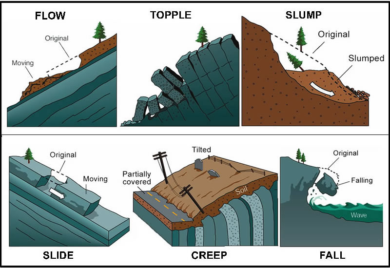
- A landslide can be defined as the movement of a mass of rock, debris, or earth down a slope.
- They are a type of mass wasting, which denotes any downward movement of soil and rock under the direct influence of gravity.
- Landslide encompasses five slope movement modes: falls, topples, slides, spreads, and flows.
- Causes:
- Slope movement occurs when forces acting downward (mainly due to gravity) exceed the strength of the earth materials that compose the slope.
- Landslides are caused due to three major factors: geology, morphology, and human activities.
- Geology refers to characteristics of the material. The earth or rock might be weak or fractured, or different layers may have different strengths and stiffness.
- Morphology refers to the structure of the land. For example, slopes that lose their vegetation to fire or drought are more vulnerable to landslides.
- Vegetation holds soil in place, and without the root systems of trees, bushes, and other plants, the land is more likely to slide away.
- Human activities like mining and construction increase the risk of a landslide.
How Vulnerable is India to Landslides?
- Landslide-Prone Area:
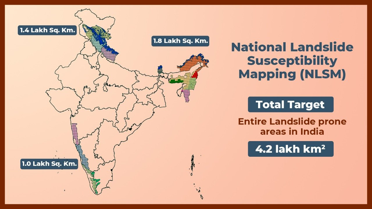
- According to the Geological Survey of India (GSI),roughly 13% of India's landmass, translating to approximately 4.2 lakh km2, is prone to landslides. This encompasses almost all hilly regions spread across 15 states and 4 Union Territories.
- Natural causes like heavy rainfall is the most common trigger for landslides in India. Earthquakes can also trigger landslides but are less frequent.
- According to the Geological Survey of India (GSI),roughly 13% of India's landmass, translating to approximately 4.2 lakh km2, is prone to landslides. This encompasses almost all hilly regions spread across 15 states and 4 Union Territories.
- High Vulnerability in Northeast:
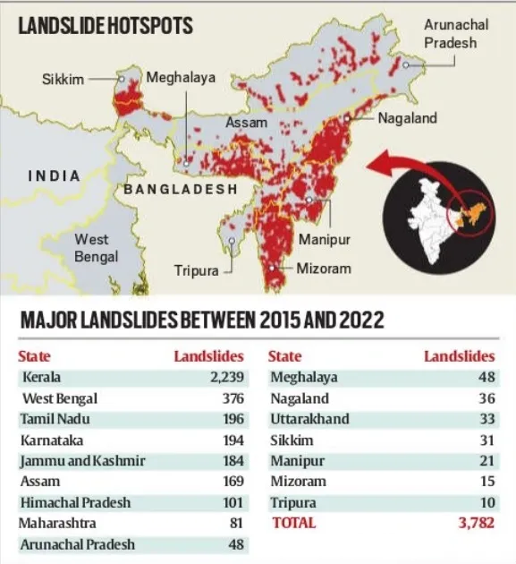
- The Northeast region bears the brunt of India's landslide vulnerability. Around 42% of the country's total landslide-prone area falls within this region, concentrated in hilly states like Meghalaya, Mizoram, Assam, and Nagaland.
- The Northeast region experiences a disproportionately high frequency of landslides. During the period 2015-2022, 10% of all major landslides in India occurred in the Northeast, translated to an average of 54 major landslides per year in the region.
- Causes of Vulnerability:
- In the Northeastern Himalayas, presence of young, weak rocks and steep slopes make it landslide-prone. Heavy monsoon rains further weaken the soil which is further affected by deforestation. Sometimes, Earthquakes and climate change add to the region's landslide problems.
- Human Factors like unregulated construction in hilly areas, infrastructure development projects, and certain agricultural practices can significantly increase the risk of landslides.
- A recent example is the collapse of a stone quarry in Aizawl, Mizoram during Cyclone Remal, which highlights the extent of unregulated construction that can lead to fatalities during landslides.
What are the Government Initiatives to Mitigate the Risk of Landslides?
- National Landslide Risk Management Strategy (2019):
- This strategy by the National Disaster Management Authority (NDMA) outlines a comprehensive approach to landslide risk reduction highlights issues of inadequate urban planning and the absence of a comprehensive land use policy.
- Landslide Atlas of India:
- Scientists did a risk assessment on the basis of 80,000 landslides recorded between 1998 and 2022 in 147 districts in 17 states and two Union Territories to build a Landslide Atlas of India.
- Early Warning System Development:
- These systems often use rainfall data (earthquake related landslides can’t be predicted) and real-time monitoring to predict potential events.
- For example, pilot programs for rainfall-based early warning systems are underway in states like Nagaland and Sikkim.
- Central Building Research Institute (CBRI) and IIT Roorkee are installing early warning systems at different locations in Sikkim, Uttarakhand, and Kerala.
What are the Major Challenges in Mitigating Landslide Risks in India?
- Limited Understanding of Landslide Prone Areas:
- Detailed geological mapping and risk assessments are often lacking, hindering efforts to prioritise mitigation measures.
- Unsustainable Land-Use Practices:
- Deforestation, unplanned development on slopes, and poor construction practices further increases landslide risks.
- Resource Constraints:
- Implementing robust mitigation measures like retaining walls, drainage systems, and slope stabilisation can be expensive.
- India lacks a comprehensive network of sensors (rain gauges, tiltmeters, etc.) to detect early warning signs of landslides.
- Public Awareness and Preparedness:
- Communities living in landslide-prone areas are not adequately informed about the risks and the ways to prepare for them.
Way Forward
- The Madhav Gadgil Committee (2010) and the Kasturirangan Committee (2012) reports, while focusing on the Western Ghats, made some recommendations that can be applied more broadly to landslide mitigation in India:
- Focus on Ecologically Sensitive Zones (ESZs):
- The reports proposed classifying a significant portion of the Western Ghats as ESZs. This classification aims to restrict activities like mining, quarrying, and large infrastructure projects that can destabilise slopes and contribute to landslides.
- Emphasis on Sustainable Land-Use Practices:
- These advocated for promoting sustainable land-use practices like agroforestry and traditional farming methods to minimise soil erosion and maintain slope stability.
- Community Involvement:
- The report highlighted the importance of involving local communities in landslide risk assessment, mitigation efforts, and disaster preparedness.
- Focus on Ecologically Sensitive Zones (ESZs):
- Slope Stabilisation using Soil Nailing and Hydroseeding Method:
- Tamil Nadu state highways department in the Nilgiris is undertaking slope stabilisation work at five locations.
- Soil nailing, a geotechnical engineering technique involving the insertion of reinforcing elements into the soil to strengthen it, is being used for slope stabilisation.
- After strengthening the slope using soil nailing, the process of ‘hydroseeding’ is being used to facilitate the growth of grass and plant-life, which will help hold the topsoil together and prevent soil erosion.
Conclusion
By implementing these measures, India can significantly improve its preparedness for multi-hazard disasters and mitigate the devastating impacts of landslides. Building a culture of resilience and prioritising sustainable development in vulnerable regions are crucial for safeguarding lives and infrastructure in the long run.
|
Drishti Mains Question: Q. In the context of the vulnerabilities of Northeastern India to landslides, discuss the government initiatives to mitigate the risk of landslides. |
UPSC Civil Services Examination, Previous Year Questions (PYQs)
Mains:
Q. Differentiate the causes of landslides in the Himalayan region and Western Ghats. (2021)
Q. The Himalayas are highly prone to landslides. Discuss the causes and suggest suitable measures of mitigation. (2016)


