Chinese Bridge on Pangong Lake | 03 Aug 2024
Why in News?
China has completed and operationalised a bridge connecting the north and south banks of the Pangong Tso lake in Eastern Ladakh.
- It allows China’s People's Liberation Army (PLA) to significantly reduce the time needed to mobilise its troops and tanks.
What is the Pangong Lake Dispute?
- About the Lake:
- Pangong Tso is a long, narrow, deep, endorheic lake at over 14,000 ft in Ladakh in trans-Himalays.
- India and China have around one-third and two-thirds of Pangong Tso Lake respectively.
- The eastern end of Pangong Tso lies in Tibet.
- It is a tectonic lake formed when India came out of Gondwanaland and pressed against Asia to create a Himalayan mountain range while occupying the space that originally was the Tethys Ocean.
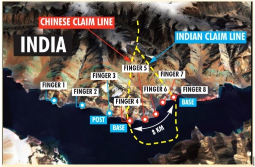
- Disputed “Fingers” Area:
- The northern bank of the lake has spurs known as "fingers."
- India claims the LAC runs through Finger 8 but controls up to Finger 4, while China claims the LAC is at Finger 2.
- Recent tensions have led to Chinese forces blocking Indian soldiers from moving beyond Finger 2.
- Strategic Significance:
- It lies in the Chushul approach path, a potential route for Chinese offensives.
- In the 1962 war, China launched its main offensive in this area, and Indian forces fought heroically at Rezang La.
- China has built motorable roads along its banks of the lake and has a large-scale model of the area at its Huangyangtan base.
- It lies in the Chushul approach path, a potential route for Chinese offensives.
What are Indian Concerns Regarding the Bridge on Pangong Lake?
- It will give Chinese troops and tanks faster access to the lake's southern banks, including Rezang La, where Indian forces outmanoeuvred them in 2020.
- The Indian Army captured key heights on the southern bank of Pangong Tso lake in 2020. The new Chinese bridge was built in response to this.
- It will reportedly strengthen the PLA's Moldo Garrison on the Pangong lake's southern bank.
- It will also enable the PLA to rapidly reinforce the Moldo Garrison by deploying motorized brigades based in Rutog base.
India and China Border Dispute
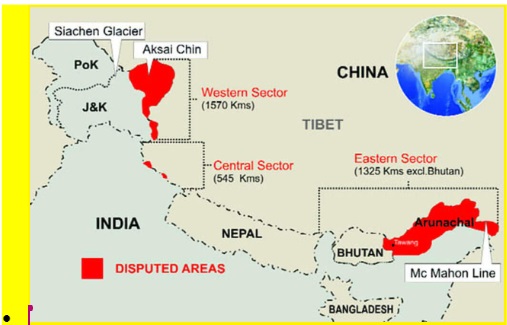
- The India-China border (3,488-kilometre) is not clearly defined in some areas, and there is no mutually agreed Line of Actual Control (LAC) in certain stretches. The LAC was established after the 1962 Indo-China war.
- The India-China border is divided into three sectors:
- Western Sector: Ladakh
- Middle Sector: Himachal Pradesh and Uttarakhand
- Eastern Sector: Arunachal Pradesh and Sikkim
- The main areas of dispute are Aksai Chin, located in the western sector, and Arunachal Pradesh, in the eastern sector.
- Aksai Chin is administered by China as part of Xinjiang, but India claims it as part of Ladakh.
- China claims the entire state of Arunachal Pradesh, calling it "South Tibet," while India is an integral part of its territory.
Other Chinese Military Infrastructure Along LAC
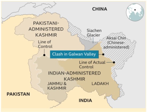
- Connectivity: Construction of road from north of Samzungling to the Galwan Valley,
- Underground Bunkers: Construction of new underground bunkers, camps, shelters, artillery positions, radar sites, and ammunition dumps along the LAC.
- Air Combat: Deployment of additional fighters, bombers, reconnaissance aircraft, and drones to counter high-altitude combat challenges.
- Border Villages: Construction of new dual-use ‘Xiaokang’ border villages.
- Rear Area Infrastructure: Strengthening of military and transport infrastructure in buffer zones on both banks of Pangong Tso.
How India Responded with Military Infrastructure Along LAC?
- Road Construction: Nearly 6,000 km of roads constructed in border areas in the past five years, with 2,100 km along the northern borders. E.g., Darbuk-Shyok-Daulat Beg Oldie (DSDBO) road.
- Tunnels: All-weather connectivity projects in Ladakh e.g., Zojila and Z-Morh tunnels and Arunachal Pradesh e.g., Sela tunnel and Nechiphu bridge are advancing.
- Troop Habitat: Rs 1,300 crore spent in the last three years on infrastructure and habitat in Ladakh, including green solutions like Sheela shelters and fuel cells.
- Air Power Infrastructure: Increasing availability of heavy lift and logistics helicopters for resupplying materials e.g., deployment of C17 Globemaster and C-130J Super Hercules.
UPSC Civil Services Examination, Previous Year Question (PYQ)
Prelims:
Q. Siachen Glacier is situated to the (2020)
(a) East of Aksai Chin
(b) East of Leh
(c) North of Gilgit
(d) North of Nubra Valley
Ans: (d)
Mains:
“China is using its economic relations and positive trade surplus as tools to develop potential military power status in Asia”. In the light of this statement, discuss its impact on India as her neighbour. (2017)