Disaster Management
20 Years of Indian Ocean Tsunami 2004
- 26 Dec 2024
- 11 min read
For Prelims: Sunda Trench, Indo-Australian Plate, Burma Microplate, Eurasian Plate, Coco Islands, Andaman and Nicobar Islands, Tsunami, Volcano, Indian Tsunami Early Warning Centre (ITEWC), Indian National Centre for Ocean Information Services (INCOIS), Indian Ocean, Mangrove, Mahabalipuram, Nuclear Power Plants, Kalpakkam Nuclear Plant, UNESCO, Intergovernmental Oceanographic Commission (IOC), Coastal Regulation Zone (CRZ), NDMA, SDMAs.
For Mains: New initiatives in tsunami forecasting, Tsunami disaster management.
Why in News?
- 26th December 2024, marked the 20th anniversary of the 2004 Indian Ocean earthquake and tsunami.
What was the 2004 Indian Ocean Earthquake and Tsunami?
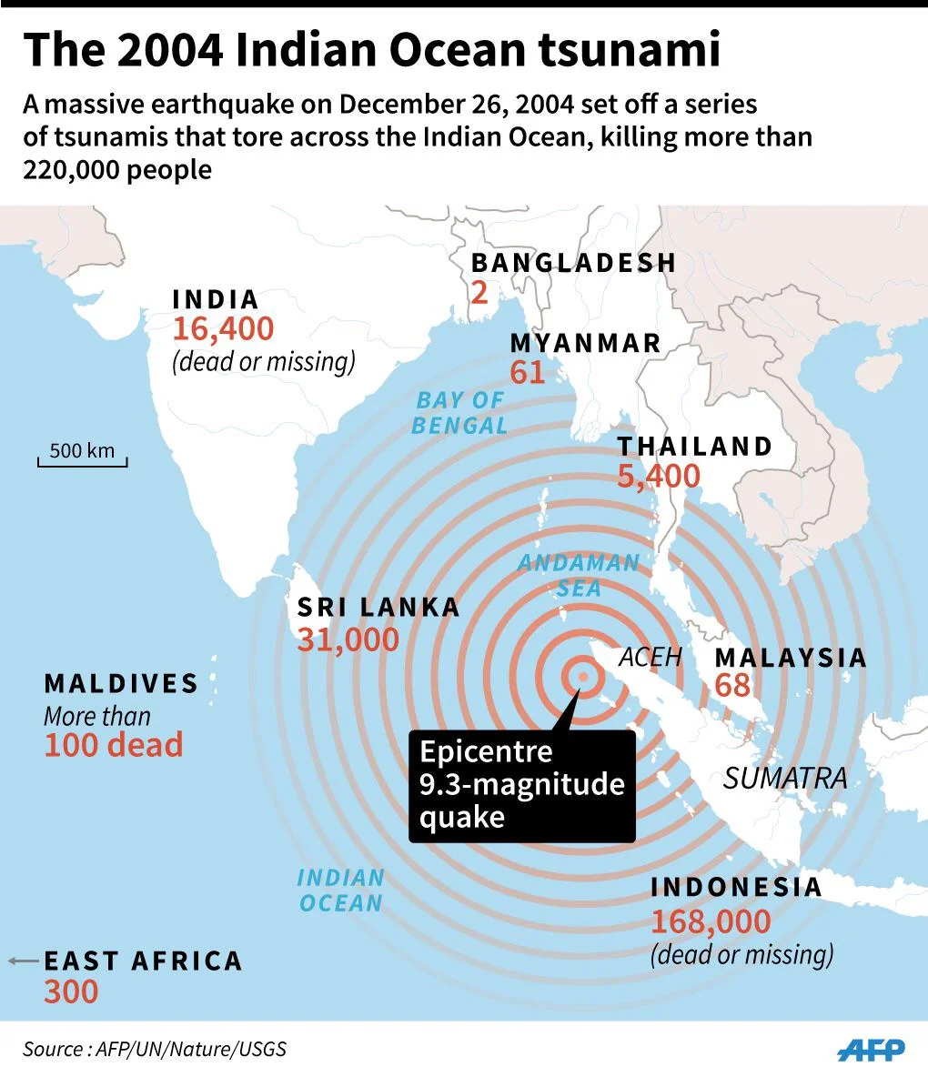
- Origin and Cause: The earthquake had a magnitude of 9.1, making it the third-largest earthquake [Others two: Chile, 1960 (magnitude 9.5) and Alaska, 1964 (magnitude 9.2)] recorded globally since 1900.
- The earthquake originated in the Sunda Trench, where the Indo-Australian plate subducts beneath the Burma microplate (part of the Eurasian plate).
- Geographic Impact: It affected an astounding 1,300 km from Sumatra in the south to the Coco Islands in the north.
- The earthquake’s tremors were felt across Indonesia, Bangladesh, India, Malaysia, Maldives, Myanmar, Singapore, Sri Lanka, and Thailand.
- In Car Nicobar, the Indian air force base was completely destroyed, underscoring the scale of destruction.
- Death and Displacement: The tsunami resulted in an estimated over 227,000 deaths, making it the deadliest tsunami in recorded history.
- Over 1.7 million people were displaced due to the destruction of homes and infrastructure.
- Lessons for India: India didn't anticipate such a large event along India's eastern coast, as the only previous tsunamis occurred in 1881 (from a large earthquake near Car Nicobar island) and 1883 (from the Krakatoa explosion), both producing only small surges.
- Reduction in Mortality: The 1999 Odisha super cyclone killed over 10,000 people while Cyclone Yaas (2021) resulted in fewer than six casualties that shows India has made significant progress in disaster risk reduction (DRR).
- However, infrastructure damage caused due to cyclones is still a cause of concern. E.g., Cyclone Dana (2024) caused widespread damage in Odisha that is estimated at Rs 616 crore.
Tsunami
- Tsunamis are giant waves caused by earthquakes or volcanic eruptions under the sea.
- It is also caused by landslides, nuclear explosion, seamount collapse, and meteorite impact.
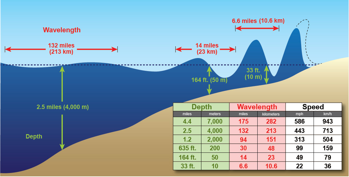
- Out in the depths of the ocean, tsunami waves do not dramatically increase in height.
- But as the tsunami approaches land, they build up to higher and higher heights as the depth of the ocean decreases.
- The speed of tsunami waves depends on ocean depth rather than the distance from the source of the wave.
- Tsunami waves may travel as fast as jet planes over deep waters, only slowing down when reaching shallow waters.
- Tsunami Prone Areas: India is vulnerable to various natural and human-made disasters due to its unique geo-climatic and socio-economic conditions.
- Of the 7,516 km long coastline, close to 5,700 km is prone to cyclones and tsunamis.
What Initiatives Were Taken after the 2004 Indian Ocean Tsunami to Minimise Damages?
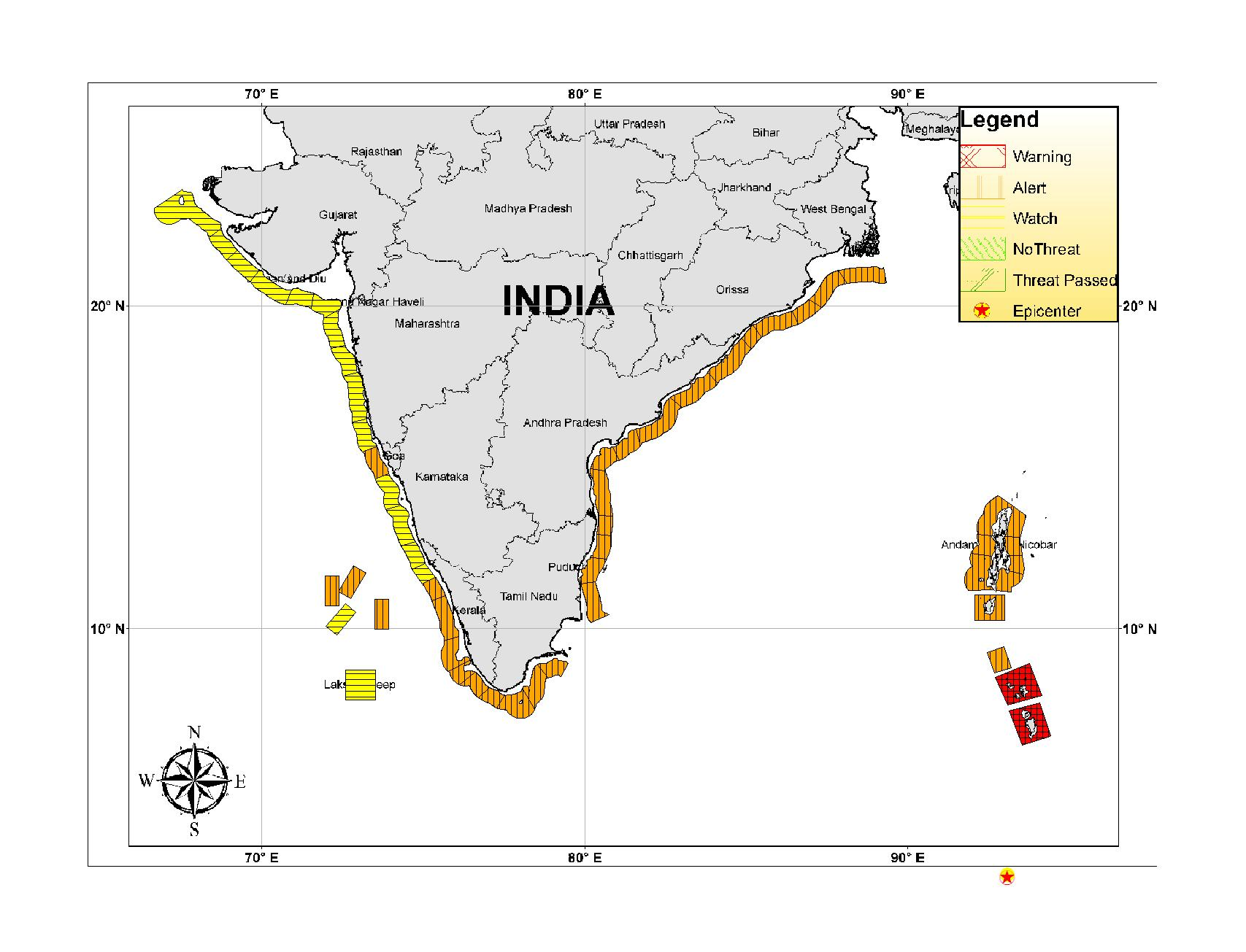
- Early Warning Systems: The Indian Tsunami Early Warning Centre (ITEWC) was established in 2007 by the Union Ministry of Earth Sciences.
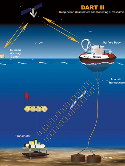
- ITEWC operates from the Indian National Centre for Ocean Information Services (INCOIS) in Hyderabad, using seismological stations, bottom pressure recorders, and tidal stations across the Indian Ocean basin to detect and issue early warnings for potential tsunamis.
- The ITEWC functions as an approved Tsunami Service Provider of the Indian Ocean Tsunami Warning & Mitigation System (IOTWMS) that is an integral part of the Global Tsunami Warning and Mitigation System.
- Global, there are around 150 stations worldwide monitoring seismic activity, and Deep-ocean Assessment and Reporting of Tsunamis (DART) buoys track changes in pressure on the seafloor to detect tsunami generation.
- ITEWC operates from the Indian National Centre for Ocean Information Services (INCOIS) in Hyderabad, using seismological stations, bottom pressure recorders, and tidal stations across the Indian Ocean basin to detect and issue early warnings for potential tsunamis.
- Real-time Monitoring: Real-time ocean monitoring systems were developed to detect tsunami-producing earthquakes and issue alerts in as little as 10 minutes.
- India became the 5th country globally to have an advanced tsunami warning system, joining the US, Japan, Chile, and Australia.
- Globally, sea-level monitoring stations have increased from just one in 2004 to 14,000 today, to detect rising sea levels and potential tsunamis.
- Technological Advancements: The early warning systems now use better algorithms and faster supercomputers enabling rapid modeling, allowing for faster and more accurate predictions of tsunami behavior.
- Tsunami Geology Research: The work of tsunami geology, pioneered by Brian Atwater of the US Geological Survey started to search for evidence of tsunamis in history.
- Investigations of mangrove swamps and coastal areas led to the discovery of past tsunami events (1,000 years ago) in the Andaman and Nicobar Islands and Mahabalipuram (a port of the Pallava dynasty).
- Research on Slow Slips: Researchers started studying seismic slips at plate boundaries to understand the processes that occur before and after major earthquakes.
- Investigations indicated a perceptible downward ground movement in South Andaman between 2003 and 2004, before the megathrust earthquake of 2004.
- Nuclear Plant Vulnerability Studies: Following the 2004 tsunami, researchers assessed the vulnerability of nuclear power plants, such as Kalpakkam, to tsunami risks.
- The Kalpakkam nuclear plant shut down automatically due to rising water levels and the reactor restarted after six days.
- Inundation Studies: Tsunami modelling using mathematical tools helped identify inundation limits and assess risks to coastal infrastructure.
- Focus on High-Risk Areas: Experts began to study other high-risk areas like the Makran Coast (Iran and Pakistan) and the Myanmar coast.
- The Makran Coast could direct a tsunami towards India's west coast, impacting Mumbai and nuclear reactors.
- Global Cooperation: The tsunami warning system has become more globally coordinated, with countries working together to monitor earthquakes and tsunamis.
- E.g., After the 2004 Indian Ocean tsunami, UNESCO Intergovernmental Oceanographic Commission (IOC) was tasked with establishing global tsunami warning services across ocean basins.
What are NDMA Guidelines Tsunami Mitigation?
- Risk Mapping: Conducting comprehensive tsunami risk assessments for vulnerable coastal areas, identifying the regions at the greatest risk from tsunamis.
- Early Warning System: Establishing and maintaining an effective tsunami early warning system that includes seismic sensors, tide gauges, and ocean buoys to monitor potential tsunami threats.
- Disseminate tsunami warnings through channels like SMS, radio, television, and public announcement systems.
- Coastal Zoning: Relevant authorities to implement the Coastal Regulation Zone (CRZ) Notification for controlled and sustainable development in coastal areas.
- Promoting safe development in low-risk areas, with a focus on natural buffers like mangroves and sand dunes.
- Tsunami-Resilient Infrastructure: Building tsunami-safe infrastructure, including elevated buildings, reinforced structures, and emergency shelters above expected tsunami wave heights.
- Constructing seawalls, breakwaters, and embankments in high-risk areas to reduce the impact of tsunami waves.
- Community Preparedness: Conducting regular public awareness campaigns on tsunami risks, warning signs, and emergency actions.
- Creating tsunami evacuation plans for coastal areas with clear signage, maps, and regular drills.
- Institutional Framework: Coordinating national, state, and local agencies, including NDMA and SDMAs, for effective tsunami mitigation and response.
- Response and Recovery: Developing tsunami response and recovery plans with search and rescue, medical aid, shelters, and food and water distribution.
- Establishing strategies for reconstructing affected areas, including financial and logistical support for rebuilding homes, infrastructure, and livelihoods.
Conclusion
The 2004 Indian Ocean tsunami highlighted critical gaps in early warning systems, prompting significant advancements in global and regional tsunami preparedness. Initiatives such as the establishment of ITEWC, enhanced monitoring, and international cooperation have drastically improved disaster response, yet challenges remain, particularly in developing nations.
|
Drishti Mains Question: Discuss the initiatives taken post-2004 Indian Ocean tsunami to improve early warning systems. |
UPSC Civil Services Examination Previous Year Question (PYQ)
Mains
Q. Discuss about the vulnerability of India to earthquake related hazards. Give examples including the salient features of major disasters caused by earthquakes in different parts of India during the last three decades. (2021)
Q.Discuss the recent measures initiated in disaster management by the Government of India departing from the earlier reactive approach. (2020)
Q. In December 2004, tsunami brought havoc on fourteen countries including India. Discuss the factors responsible for the occurrence of tsunami and its effects on life and economy. In the light of guidelines of NDMA (2010) describe the mechanisms for preparedness to reduce the risk during such events. (2017)


