Tectonic Events Changed the Course of Ganga | 10 Aug 2024
For Prelims: Ganges Delta, Paleochannel, Indo-Burma Mountain Ranges, Tectonic Plates, Ganges-Meghna-Brahmaputra Delta, Seismic Waves, Sand Dikes, Liquefaction, Optically Stimulated Luminescence (OSL) Dating, Flood, Subsidence
For Mains: Role of Important Geophysical Phenomena in shaping the of Earth.
Recently, Researchers studied river channels in the Ganges delta in Bangladesh.
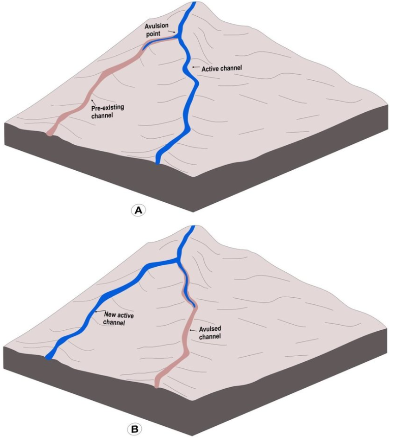
- They discovered a paleochannel (ancient river channel) indicating the Ganga had changed its course abruptly about 2,500 years ago due to an earthquake.
How Earthquakes Impact the Course of a River Ganga?
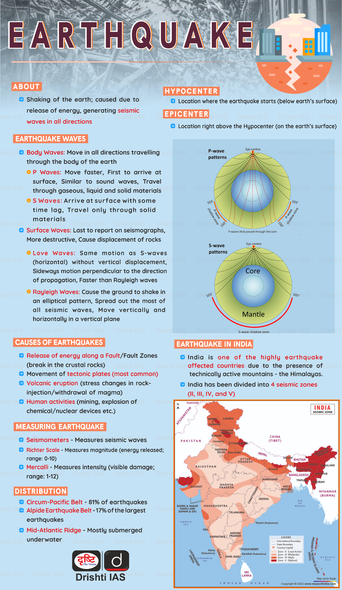
- Earthquake Origin: The researchers speculated the earthquake could have originated from the Indo-Burma mountain ranges or the Shillong hills, where the Indian and Eurasian tectonic plates meet.
- Impact: The discovery highlights that large earthquakes can trigger major river avulsions (changes in the course of river flow), which could lead to devastating floods, especially in densely populated regions like the Ganges-Meghna- Brahmaputra delta.
- Earthquake Evidence:
- Seismite Formation: Seismites (sedimentary beds deformed by seismic movements) are formed when seismic waves pressurise a layer of watery sand, causing it to burst through mud layers.
- Sand Dikes: Researchers found two large sand dikes a kilometre to the east of the palaeochannel. Sand Dikes are formed when earthquakes disturb the river bed and cause sediments to flow (liquefaction).
- Dating Techniques: Researchers used optically stimulated luminescence (OSL) dating to estimate the timing of the avulsion and the formation of the sand dikes. They determined that both events occurred around 2,500 years ago, suggesting the earthquake caused the river avulsion.
- Future Hazards and Recommendations:
- Potential Impact: A similar earthquake today could flood areas affecting up to 170 million people in India and Bangladesh.
- Increased Risk: Factors such as rapid subsidence and climate change-induced sea level rise increase the risk of river avulsions.
- Future Research: Emphasis should be placed on understanding the frequency of quake-driven avulsions and improving earthquake forecasting.
- Preparedness: There is a need for collaboration between India, Bangladesh, and Myanmar for research, monitoring, and preparedness to mitigate the risks associated with such natural disasters.
What are Tectonic Activities?
- Tectonic Activities:
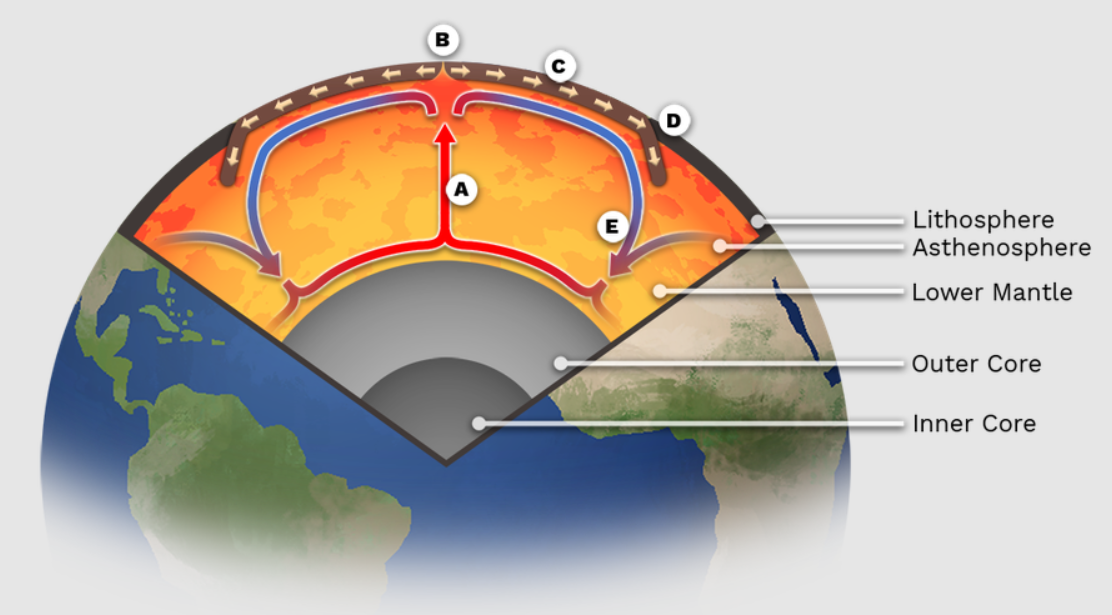
- The Earth's outermost layer, the lithosphere (comprising the crust and upper mantle), is broken into large rocky plates.
- These plates rest on a partially molten layer called the asthenosphere.
- Due to convection current in the asthenosphere, the plates move at different rates, from 2-15 centimetres per year.
- This movement creates various geological formations, including the Himalayas, the East African Rift and the San Andreas Fault in California.
- It explains how major landforms including the formation of mountains, volcanic activity, and earthquakes are created by the movements beneath the Earth's surface.
- The seven major plates listed from largest to smallest are the Pacific, NorthAmerican, Eurasian, African, Antarctic, Indo-Australian and the South American Plate.
- The Earth's outermost layer, the lithosphere (comprising the crust and upper mantle), is broken into large rocky plates.
- Earthquakes due to Tectonic Activities:
- Tectonic activities lead to earthquakes primarily through the movement of the Earth's tectonic plates.
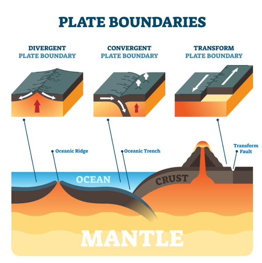
- Earthquakes typically occur at the boundaries of tectonic plates, which can be categorised into three main types:
- Convergent Boundaries: Plates move toward each other, causing one plate to be forced beneath another (subduction). This process can create intense pressure and lead to powerful earthquakes.
- Divergent Boundaries: Plates move apart from each other, allowing magma to rise and create new crust. Earthquakes here are usually less powerful but frequent.
- Transform Boundaries: Plates slide past each other horizontally. The friction between the plates can cause stress to build up, which, when released, results in an earthquake.
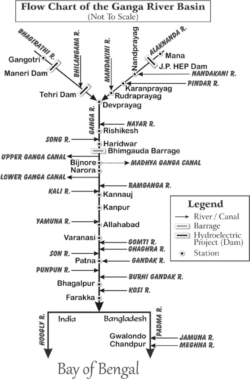
What are Key Facts About the Ganga River System?
- The Ganga originates as Bhagirathi from Gangotri Glacier, Uttarakhand at an elevation of 3,892 m.
- Many small streams comprise the headwaters of the Ganga. The important among these are Alaknanda, Dhauliganga, Pindar, Mandakini and Bhilangana.
- At Devprayag, where Alaknanda joins Bhagirathi, the river acquires the name Ganga. It traverses 2525 km before flowing into the Bay of Bengal.
- The Ganga is formed from the 6 headstreams and their five confluences.
- Devprayag: Confluence of Bhagirathi river and Alaknanda river.
- Rudraprayag: Confluence of Mandakini river and Alaknanda river.
- Nandaprayag: Confluence of Nandakini river and Alaknanda river.
- Karnaprayag: Confluence of Pindar river and Alaknanda river.
- Vishnuprayag: Confluence of Dhauliganga river and Alaknanda river.
- The Bhagirathi, considered to be the source stream, rises at the foot of Gangotri Glacier, at Gaumukh. It finally empties into the Bay of Bengal.
- Major Tributaries of the Ganga River:
- Left Bank Tributaries: Ramganga, Gomti, Ghaghara, Gandak, Burhi Gandak, Koshi, Mahananda.
- Right Bank Tributaries: Yamuna, Tons, Karamnasa, Sone, Punpun, Falgu, Kiul, Chandan, Ajoy, Damodar, Rupnarayan.
- The Ganga flows out of the hills and into the plains at a point where it meets the Yamuna in Allahabad.
- Delta and Outflow:
- After a journey of around 2,510 kilometres, the Ganga River merges with the Brahmaputra River in Bangladesh, forming the Padma River.
- The Padma River then joins the Meghna River and flows into the Bay of Bengal through the Meghna Estuary.
- After a journey of around 2,510 kilometres, the Ganga River merges with the Brahmaputra River in Bangladesh, forming the Padma River.
Tectonic Movement and Decline of Harappan Civilization
- Multiple layers of silt at Mohenjodaro show that repeated Indus river floods contributed to the decline of the Harappan civilization.
- Researchers argued that the floods at Mohenjodaro were the result of tectonic movements.
- The theory states that the Indus area is a disturbed seismic zone and tectonic movements led to the creation of a gigantic natural dam that prevented the Indus from flowing towards the sea, turning the area around Mohenjo Daro into a huge lake.
- It caused prolonged submergence of the cities located on the bank of the river Indus.
- They argued that such flooding which could drown buildings 30 feet above the ground level of the settlement could not be the result of normal flooding in the river Indus.
- However, few researchers pointed out that the idea that a river would be dammed in such a manner even by tectonic uplifts is not convincing.
|
Drishti Mains Question: Q. What is Plate Tectonics? How does it affect the various geophysical phenomena on Earth? |
UPSC Civil Services Examination Previous Years’ Questions (PYQs)
Mains
Q. Mention the global occurrence of volcanic eruptions in 2021 and their impact on the regional environment. (2021)
Q. Briefly mention the alignment of major mountain ranges of the world and explain their impact on local weather conditions, with examples. (2021)
Q. Explain the formation of thousands of islands in Indonesian and Philippines archipelagos. (2014)