Important Facts For Prelims
NISAR Satellite
- 14 Nov 2024
- 5 min read
Why in News?
The NASA-ISRO Synthetic Aperture Radar (NISAR) satellite, a collaborative effort between National Aeronautics and Space Administration (NASA) and Indian Space Research Organisation (ISRO), is scheduled to launch in early 2025.
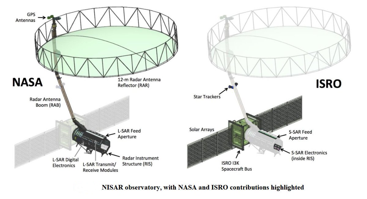
- It integrates two advanced radar systems—NASA’s L-band radar and ISRO's S-band radar—marking it as the first satellite to carry both.
What is NISAR?
- About:
- It was built in collaboration with the US and India under a partnership agreement signed in 2014, and is set to launch from Satish Dhawan Space Centre in Andhra Pradesh, India.
- The satellite will be launched into low Earth orbit using ISRO's Geosynchronous Satellite Launch Vehicle Mark II.
- Objective: It will map the entire globe every 12 days, offering consistent data on ecosystems, ice mass, vegetation, sea level rise, groundwater, and natural hazards like earthquakes, tsunamis, volcanoes, and landslides.
| Feature | Details |
| Thermal Blanketing | Gold-coloured thermal blankets regulate the satellite's temperature during operation. |
| Key Components |
Radar Payload: Core instrument for surface observation. Spacecraft Bus: Provides power, communications, navigation, and pointing control for satellite operations. Antenna and Reflector: 12 metre diameter drum-shaped wire-mesh reflector, the largest in space, enhances radar signal focus and observation capabilities. |
| Technological Advancements |
Dual Radar Systems: Combines NASA’s L-band radar and ISRO’s S-band radar: L-band Radar: Penetrates dense vegetation to measure ground motion, ideal for volcanic and seismic zones. S-band Radar: Improves surface monitoring precision; operates on 8-15 cm wavelength and 2-4 GHz frequency. |
Applications of NISAR
- Comprehensive Monitoring: NISAR captures Earth's surface movements (horizontal & vertical) with high clarity, functioning day and night through clouds.
- Disaster Mitigation: Tracks seismic activities, landslides, volcanic events, and ice sheet shifts for disaster impact reduction.
- Environmental Tracking: Monitors forests, wetlands, farmlands, and deforestation to support sustainable resource management.
- Infrastructure Stability: Assesses infrastructure, monitors urbanisation, and detects oil spills for better management.
- Data-Driven Decision-Making: Supports understanding tectonic movements and promotes informed, sustainable, and economic use of resources.
UPSC Civil Services Examination, Previous Year Question (PYQ)
Prelims
Q. Consider the following statements: (2016)
The Mangalyaan launched by ISRO
- is also called the Mars Orbiter Mission
- made India the second country to have a spacecraft orbit the Mars after USA
- made India the only country to be successful in making its spacecraft orbit the Mars in its very first attempt
Which of the statements given above is/are correct?
(a) 1 only
(b) 2 and 3 only
(c) 1 and 3 only
(d) 1, 2 and 3
Ans: (c)
Q. With reference to India’s satellite launch vehicles, consider the following statements: (2018)
- PSLVs launch the satellites useful for Earth resources monitoring whereas GSLVs are designed mainly to launch communication satellites.
- Satellites launched by PSLV appear to remain permanently fixed in the same position in the sky, as viewed from a particular location on Earth.
- GSLV Mk III is a four-staged launch vehicle with the first and third stages using solid rocket motors, and the second and fourth stages using liquid rocket engines.
Which of the statements given above is/are correct?
(a) 1 only
(b) 2 and 3
(c) 1 and 2
(d) 3 only
Ans: (a)


