Science & Technology
NISAR Mission
- 09 Feb 2023
- 5 min read
Prelims: NASA, ISRO, S band radars, GPS, Synthetic Aperture Radar.
Mains: NISAR Mission, Achievements of Indians in Science & Technology.
Why in News?
Recently, NISAR (NASA-ISRO Synthetic Aperture Radar) has received a send-off ceremony at the NASA’s (National Aeronautics and Space Administration) Jet Propulsion Laboratory (JPL) in California, USA.
- NISAR will be the first radar of its kind in space to systematically map Earth, using two different radar frequencies (L-band and S-band) to measure changes in our planet's surface less than a centimeter across.
What is the NISAR Mission?
- About:
- NISAR has been built by space agencies of the US and India under a partnership agreement signed in 2014.
- It is expected to be launched in January 2024 from Satish Dhawan Space Centre into a near-polar orbit.
- The satellite will operate for a minimum of three years.
- It is a Low Earth Orbit (LEO) observatory.
- NISAR will map the entire globe in 12 days.
- Features
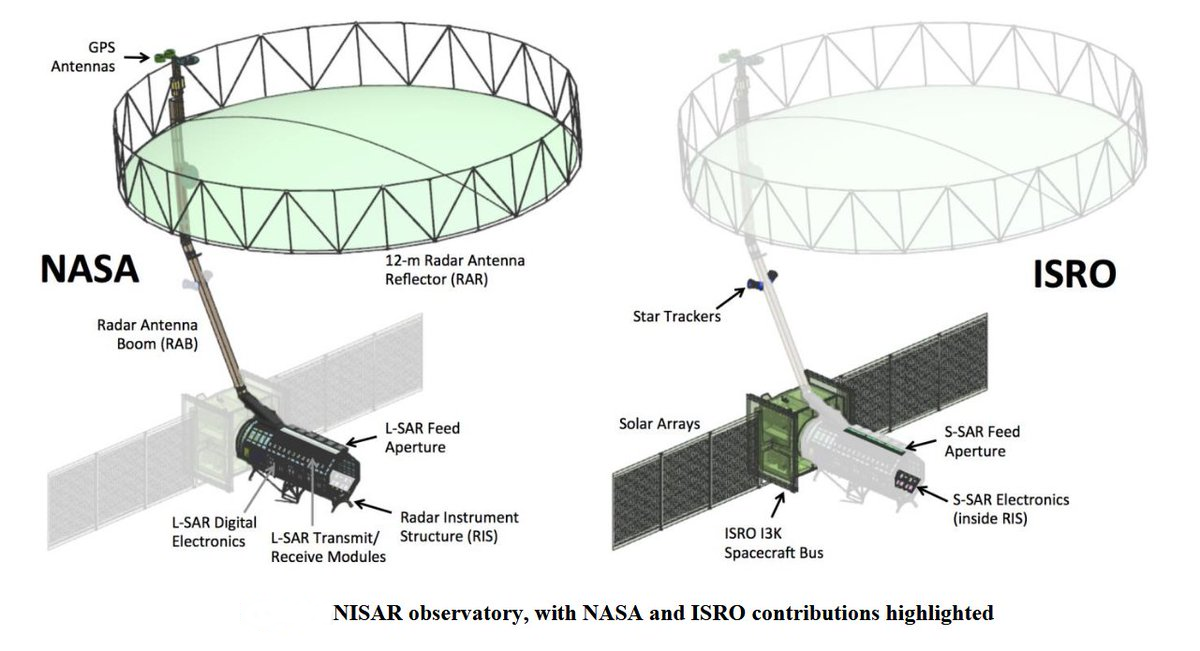
- It is a 2,800 kilograms satellite consisting of both L-band and S-band Synthetic Aperture Radar (SAR) instruments, which makes it a dual-frequency imaging radar satellite.
- While NASA has provided the L-band radar, GPS, a high-capacity solid-state recorder to store data, and a payload data subsystem, ISRO (Indian Space Research Organisation) has provided the S-band radar, the Geosynchronous Satellite Launch Vehicle (GSLV) launch system and spacecraft.
- S band radars operate on a wavelength of 8-15 cm and a frequency of 2-4 GHz. Because of the wavelength and frequency, they are not easily attenuated. This makes them useful for near and far range weather observation.
- It has a 39-foot stationary antenna reflector, made of a gold-plated wire mesh; the reflector will be used to focus “the radar signals emitted and received by the upward-facing feed on the instrument structure.
- By using SAR, NISAR will produce high-resolution images. SAR is capable of penetrating clouds and can collect data day and night regardless of the weather conditions.
- NASA requires the L-band radar for its global science operations for at least three years. Meanwhile, ISRO will utilise the S-band radar for a minimum of five years.
What are the Expected Benefits of NISAR?
- Earth Science: NISAR will provide a wealth of data and information about the Earth's surface changes, natural hazards, and ecosystem disturbances, helping to advance our understanding of Earth system processes and climate change.
- Disaster Management: The mission will provide critical information to help manage natural disasters such as earthquakes, tsunamis, and volcanic eruptions, enabling faster response times and better risk assessments.
- Agriculture: NISAR data will be used to improve agriculture management and food security by providing information about crop growth, soil moisture, and land-use changes.
- Infrastructure Monitoring: The mission will provide data for infrastructure monitoring and management, such as monitoring of oil spills, urbanization, and deforestation.
- Climate Change: NISAR will help to monitor and understand the impacts of climate change on the Earth's land surface, including melting glaciers, sea-level rise, and changes in carbon storage.
UPSC Civil Services Examination, Previous Year Question (PYQ)
Prelims
Q. Consider the following statements: (2016)
The Mangalyaan launched by ISRO
- is also called the Mars Orbiter Mission
- made India the second country to have a spacecraft orbit the Mars after USA
- made India the only country to be successful in making its spacecraft orbit the Mars in its very first attempt
Which of the statements given above is/are correct?
(a) 1 only
(b) 2 and 3 only
(c) 1 and 3 only
(d) 1, 2 and 3
Ans: (c)
Mains
Q1. What is India’s plan to have its own space station and how will it benefit our space programme? (2019)
Q2. Discuss India’s achievements in the field of Space Science and Technology. How the application of this technology has helped India in its socio-economic development? (2016)


