Ninetyeast Ridge | 09 Dec 2024
For Prelims: Ninetyeast Ridge, Indian Ocean, Natural disasters, Bay of Bengal, Submarine volcanism, Seamounts, Early warning systems, Tectonic Plates
For Mains: Plate Tectonics and Hotspot , Tectonic Plate Movements and Natural Disasters
Why in News?
A recent Nature Communications study reveals that the Ninetyeast Ridge, the Earth's longest straight underwater mountain chain, was formed by a moving hotspot, challenging the earlier belief that it originated from a stationary hotspot.
- This study provides new insights into Earth’s tectonic processes, and age estimates of Ninetyeast Ridge.
What are the Key Findings of the Study?
- Formation by a Moving Hotspot: The Ninetyeast Ridge, a 5,000 km-long underwater mountain chain in the Indian Ocean, was formed by the Kerguelen hotspot(volcanic hotspot located at the Kerguelen Plateau in the Southern Indian Ocean), which moved several hundred kilometers within the Earth's mantle, rather than being formed by a stationary hotspot as previously believed.
- The study is the first documented case of a moving hotspot in the Indian Ocean, contributing new evidence to the theory of hotspot movement, which has been difficult to prove.
- Age Estimates: High-precision dating of mineral samples from the ridge shows that the Ninetyeast Ridge formed between 83 and 43 million years ago.
- Impact on Tectonic Models: The study provides a more accurate reconstruction of Earth's tectonic history and highlights the importance of understanding mantle dynamics and hotspot movement to better predict natural disasters.
What is the Ninetyeast Ridge?
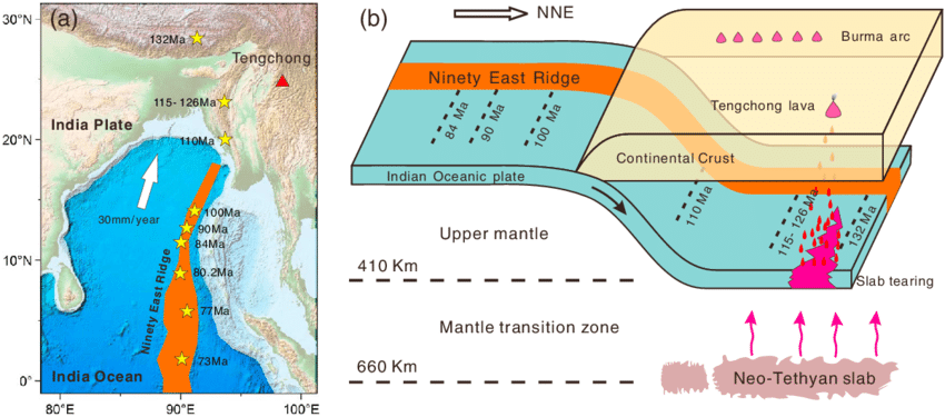
- About: The Ninetyeast Ridge is a linear aseismic ridge. It is named for its near-parallel alignment with the 90th meridian east.
- This underwater mountain range stretches approximately 5,000 kilometers from the Bay of Bengal in the north to the Southeast Indian Ridge (SEIR) in the south.
- The northern segment of the Ninetyeast Ridge has massive volcanoes, the southern part is tall and continuous, and the middle section includes small seamounts and straight segments.
- It divides the Indian Ocean into the West Indian Ocean and the eastern Indian Ocean.
- Formation of the Ninety East Ridge: The most widely accepted theory is the hotspot theory, with some geologists attributing the ridge's formation to the Kerguelen hotspot.
- As the Indo-Australian plate moved north, it passed over this hotspot, forming the ridge.
- The formation process ceased due to a reorganization in the tectonic plate boundaries, and further research ongoing to confirm this theory.
- Composition: Primarily made of Ocean Island Tholeiites (OIT), a type of sub-alkaline basalt rock.
- Rocks in the southern part of Ninetyeast Ridge are younger (43.2 million years) compared to the northern part (81.8 million years).
What is the Geological Significance of a Hotspot?
- About: A hotspot is an area where hot plumes of molten rock (magma) rise from deep within Earth's mantle. These plumes can form volcanoes on the Earth's crust as they reach the surface.
- Unlike most volcanic activity, hotspot volcanism is not driven by tectonic plate boundaries but rather by stationary plumes beneath moving plates.
- Hotspot Volcanism and Submarine Volcanism: Hotspot volcanism is different from submarine volcanism. Submarine volcanism happens where tectonic plates meet and move(plate boundaries).
- In contrast, Hotspot volcanism occurs within lithospheric plates, rather than at plate boundaries where convergence or divergence happens.
- Hotspot Track: As tectonic plates move over a hotspot, active volcanoes form above the plume, while older ones are carried away, creating a chain of islands or seamounts.
- A hotspot track is a linear chain of volcanoes formed by a stationary plume beneath a moving tectonic plate. The youngest and most active volcano is above the plume, with older volcanoes further away in the direction of plate movement.
- The Hawaiian Islands and their seamount chain are a prime example of a hotspot track, with the Island of Hawaii being the youngest and most active in the chain.
- Dynamic Nature of Hotspots: There is ongoing debate about the irregular volcanism patterns observed in island chains like the Cook-Australs, Marshalls, Gilberts, and Line Islands. Some theories suggest that hotspots, traditionally thought to be stationary, may actually be dynamic.
- The debate continues as scientists gather more data to understand the complex processes driving volcanism in these regions.
How Do Hotspots Impact Tectonic Plates and Natural Disasters?
- Hotspot Influence on Tectonic Plates:
- Volcanic Chains and Plate Movement: The sequence of these islands, from youngest to oldest, provides evidence for plate motion.
- The distance between these islands also allows scientists to estimate plate speed.
- Hotspots, linked to geothermal features like geysers, offer insights into tectonic plate movements and interactions.
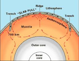
- Mantle plumes drive plate tectonics by supplying heat and movement, crucial for the large-scale motion of Earth's tectonic plates.
- Rifting and Continental Breakup: Hotspots can contribute to continental rifting, where plates pull apart.
- A mantle plume beneath a continent can weaken the lithosphere, causing it to break apart.
- The East African Rift is an example of a continent being split.
- A mantle plume beneath a continent can weaken the lithosphere, causing it to break apart.
- Volcanic Chains and Plate Movement: The sequence of these islands, from youngest to oldest, provides evidence for plate motion.
- Mantle and Hotspot Influence of Natural Disasters:
- Earthquakes: Mantle plumes and the movement of tectonic plates can lead to earthquakes. Understanding the dynamics of these movements helps in identifying regions at risk of seismic activity.
- This knowledge is essential for designing and implementing early warning systems.
- Tsunamis: Earthquakes and volcanic eruptions under the ocean can trigger tsunamis. By studying the patterns of mantle dynamics and hotspot activity, scientists can better predict the likelihood of such events and issue warnings to coastal areas.
- Earthquakes: Mantle plumes and the movement of tectonic plates can lead to earthquakes. Understanding the dynamics of these movements helps in identifying regions at risk of seismic activity.
|
Drishti Mains Question: Examine the role of hotspots in plate tectonics and their impact on the formation of volcanic islands. |
UPSC Civil Services Examination, Previous Year Question (PYQ)
Prelims
Q. Consider the following: (2013)
- Electromagnetic radiation
- Geothermal energy
- Gravitational force
- Plate movements
- Rotation of the earth
- Revolution of the earth
Which of the above are responsible for bringing dynamic changes on the surface of the earth?
(a) 1, 2, 3 and 4 only
(b) 1, 3, 5 and 6 only
(c) 2, 4, 5 and 6 only
(d) 1, 2, 3, 4, 5 and 6
Ans: (d)
Mains:
Q. Discuss about the vulnerability of India to earthquake related hazards. Give examples including the salient features of major disasters caused by earthquakes in different parts of India during the last three decades. (2021)
Q. Why are the world’s fold mountain systems located along the margins of continents? Bring out the association between the global distribution of fold mountains and earthquakes and volcanoes. (2014)


