Kosi-Mechi River Linking Project | 19 Aug 2024
For Prelims: Kosi-Mechi River Linking Project, National Perspective Plan for Interlinking Rivers, Kosi River, Mahananda River, Mechi River.
For Mains: Interlinking of Rivers in India and associated issues, Issues Relating to Development, Water Management
Why in News?
The Kosi-Mechi River Linking Project, part of India’s ambitious National Perspective Plan (NPP) for interlinking rivers, has become a point of contention. Flood victims in Bihar have protested against its implementation.
- The project is aimed at improving irrigation in the region. However, locals argue that it fails to address the critical issue of flood control, which affects them annually.
What are the Key Facts About the Kosi-Mechi River Linking Project?
- About: The project involves linking the Kosi River with the Mechi River, a tributary of the Mahananda River, impacting regions in Bihar and Nepal.
- Aims to provide annual irrigation to 4.74 lakh hectares (2.99 lakh hectares in Bihar) and 24 million cubic meters (MCM) of domestic and industrial water supply.
- Upon completion, the project is expected to release an additional 5,247 cubic feet per second (cusecs) of water from the Kosi barrage.
- The project is overseen by the National Water Development Agency (NWDA), under the Union Ministry of Jal Shakti (Water Resources).
- Aims to provide annual irrigation to 4.74 lakh hectares (2.99 lakh hectares in Bihar) and 24 million cubic meters (MCM) of domestic and industrial water supply.
- Concerns: The project is designed primarily for irrigation purposes, with an aim to support 215,000 hectares of agricultural land in the Mahananda river basin during the Kharif season.
-
Despite government claims, the project does not have a significant flood control component, which is a major concern for the flood-prone region.
- The project will release only 5,247 cubic feet per second (cusecs) of additional water from the barrage, which is negligible compared to the barrage's capacity of 900,000 cusecs.
- Locals argue that such a small reduction in water flow will not be effective in preventing the annual flooding that devastates the region.
- Flooding and land erosion have destroyed homes and inundated crops, affecting local livelihoods and villagers living between embankments.
- The project's focus on irrigation does not address these immediate and recurring challenges.
-
What are the Key Facts About Kosi River and Mechi River?
- Kosi River: It is known as the "Sorrow of Bihar," originates over 7,000 metres above sea level in the Himalayas, within the catchment area of Mount Everest and Kanchenjunga.
- Flowing through China, Nepal, and India, it enters India near Hanuman Nagar and merges with the Ganga River near Kursela in Katihar district Bihar.
- The Kosi River is formed by the confluence of three main streams: the Sun Kosi, Arun Kosi, and Tamur Kosi.
- The Kosi river is known for its tendency to shift its course westward, having moved 112 km over the last 200 years, devastating agricultural lands in Darbhanga, Saharsa and Purnea districts.
- Tributaries: The river has several important tributaries, including the Trijunga, Bhutahi Balan, Kamla Balan, and Bagmati, all of which join the Kosi River during its course through the plains.
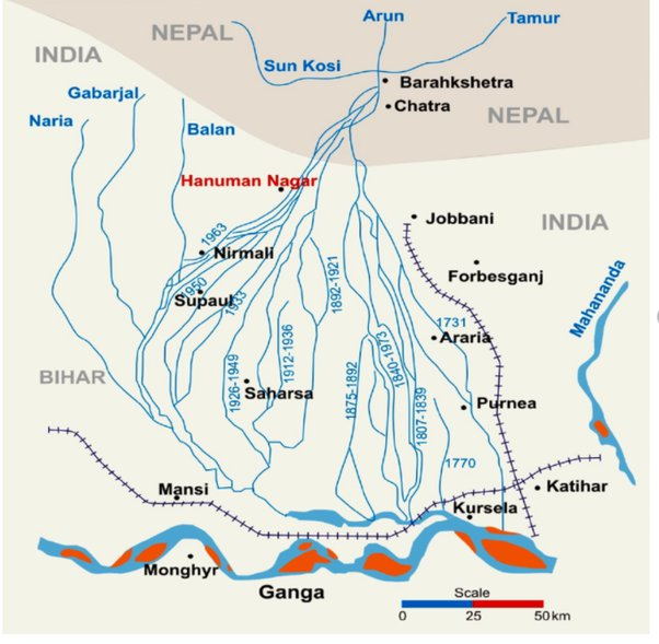
- Mechi River: It is a trans-boundary river flowing through Nepal and India. It is a tributary of the Mahananda River.
-
The river Mechi is a perennial river which rises in the inner valley of the Himalaya in Mahabharat range of hills in Nepal and then flows through the Indian state of Bihar to join the Mahananda in Kishanganj district.
-
Mahananda River
- It is a part of the Eastern Himalayan river system. The Mahananda River consists of two streams, one rises in the Himalayas in Nepal, flows through Bihar, and meets the Ganga from the north. Locally named Fulahar.
- The other rises in Darjeeling, West Bengal, enters Bangladesh, and merges with the Ganga near Godagarighat, Bangladesh. Known as Mahananda.
- Catchment Area: Stretches over the sub-Himalayan region of Nepal and West Bengal, one of the highest rainfall regions in India.
- Flooding: The streams often combine during peak monsoon months, leading to significant inundation in Bihar and West Bengal. Flooding is exacerbated when the Ganga is at its peak, causing extensive waterlogging in affected districts like Purnea and Katihar in Bihar, and Darjeeling, West Dinajpur, and Malda in West Bengal.
What is the National Perspective Plan for Interlinking Rivers?
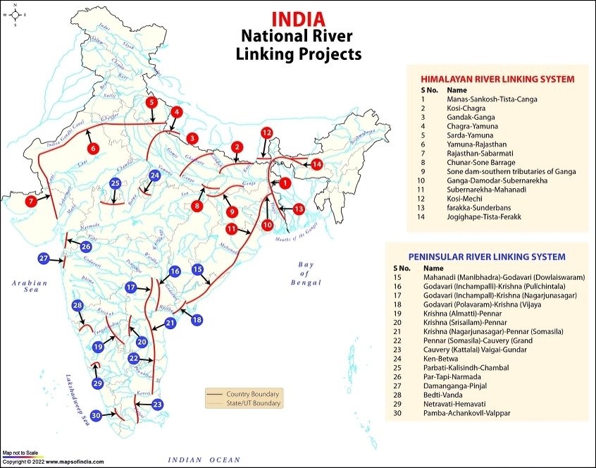
- About: NPP was formulated in 1980 by the Ministry of Irrigation (now Ministry of Jal Shakti), to develop water resources through the inter-basin transfer of water.
- Components: The plan is divided into two main components: the Himalayan Rivers Development Component and the Peninsular Rivers Development Component.
- Projects Identified: 30 link projects have been identified, with 16 under the Peninsular Component and 14 under the Himalayan Component.
- Key Projects Under Peninsular Component: Mahanadi-Godavari Links, Godavari-Krishna Links, Par-Tapi-Narmada Link, and Ken-Betwa Link (first project under the NPP to begin implementation).
- Key Projects Under Himalayan Component: Kosi-Ghaghra Link, Ganga (Farakka)-Damodar-Subernarekha Link, and Kosi-Mechi Link.
- Significance: The NPP aims to manage flood risks in the Ganga-Brahmaputra-Meghna basin.
- It seeks to address water shortages in western and peninsular states such as Rajasthan, Gujarat, Andhra Pradesh, Karnataka, and Tamil Nadu.
- The plan aims to improve irrigation in water-scarce regions, boosting agricultural productivity and thereby enhancing food security and potentially doubling farmers' incomes.
- It will facilitate the development of infrastructure for freight movement via environmentally friendly inland waterways.
- The NPP is designed to utilise surface water to alleviate groundwater depletion and reduce the amount of freshwater flowing into the sea.
- Challenges: Comprehensive feasibility studies assessing the economic, social, and ecological impacts are often incomplete or lacking.
- Inadequate data can lead to uncertainties about the project's effectiveness and potential unintended consequences.
- Water being a state subject complicates agreements on water sharing between states, leading to potential disputes. For example, issues have arisen between Kerala and Tamil Nadu.
- Large-scale water transfers can worsen flooding, disrupting local ecosystems and communities. Additionally, changes in water flow may lead to water logging and increased salinity in agricultural lands, negatively affecting soil quality and crop yields.
- The extensive financial outlay for construction, maintenance, and operation of dams, canals, and related infrastructure presents a significant economic burden.
- Climate change can alter rainfall patterns, which may affect the availability and distribution of water, potentially undermining the intended benefits of the interlinking projects.
Way Forward
- Develop a comprehensive plan for floodplain zoning, restricting settlements and critical infrastructure in high-risk areas. Encourage flood-resistant housing and cropping patterns in designated zones.
- Invest in fortifying embankments along the Kosi River to prevent breaches and reduce inundation
- Develop a clear mechanism to ensure equitable distribution of project benefits. Flood-prone areas should see significant investments in flood control measures, while water-scarce regions benefit from improved irrigation infrastructure.
- Given the challenges faced by the Interlinking of Rivers plan, adopting the National Waterways Project (NWP) offers a promising alternative.
- The NWP, which uses excess floodwaters that currently flow into the sea, avoids state disputes over water sharing and provides a more cost-effective solution for irrigation and power generation.
|
Drishti Mains Question: Q. Discuss the objectives and expected benefits of the Kosi-Mechi River Linking Project. How does it align with the broader goals of the National Perspective Plan for Interlinking Rivers? |
UPSC Civil Services Examination, Previous Year Question (PYQ)
Q. The interlinking of rivers can provide viable solutions to the multi-dimensional inter-related problems of droughts, floods, and interrupted navigation. Critically examine. (2020)