Geography
International Mountain Day 2024
- 13 Dec 2024
- 13 min read
For Prelims: Indian Himalayan Region, United Nations, Food and Agriculture Organization, Types of Mountain, Mountain Ranges in India
For Mains: Geography of the Indian Himalayan Region, Mountain Ecosystems, Indian Mountain Ranges
Why in News?
Recently, the Ministry of Environment, Forest and Climate Change observed International Mountain Day 2024 (11th December) to highlight the need to protect the Indian Himalayan Region (IHR).
What is International Mountain Day?
- History: International Mountain Day, observed on 11th December, was established by the United Nations in 2003 to raise awareness about sustainable development in mountains and their vital importance to life.
- The Food and Agriculture Organization (FAO) plays a key role in coordinating this observance.
- Theme 2024: Mountain solutions for a sustainable future – innovation, adaptation and youth.
- Importance of Mountains: Mountains cover about one-fifth of the Earth's surface and are home to 15% of the world’s population and host half of the world’s biodiversity hotspots.
- They provide essential freshwater for half of humanity acting as "water towers", supporting agriculture, clean energy, and health sectors.
- Mountains are ecological treasures that need protection. Without them, many countries would face dry, barren land. Their preservation is key to sustainable development.
What are the Key Facts About Indian Himalayan Region (IHR)?
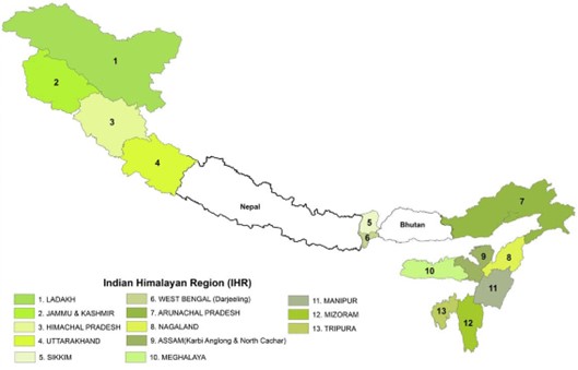
- Geographical Extent: The IHR stretches across 13 Indian states/Union Territories, including Jammu & Kashmir, Ladakh, Himachal Pradesh, Uttarakhand, Sikkim, Arunachal Pradesh, and parts of West Bengal, Assam, Nagaland, Manipur, Mizoram, Tripura and Meghalaya.
- It spans a distance of approximately 2,500 km from west to east.
- Tectonic Activity: The IHR is tectonically active due to the ongoing collision between the Indian Plate and the Eurasian Plate.
- This has led to the formation of the Himalayan mountains and continues to shape the region’s geological features.
- Geological Diversity: The region is rich in geological features, with varying rock formations, fault lines, and plateaus. There are igneous, sedimentary, and metamorphic rocks found in different sections of the Himalayas.
- Significance: The IHR covers about 16.2% of the country's total geographical area.
- The region is a biodiversity hotspot, home to numerous plant and animal species, some of which are endemic or endangered.
- The region is the source of major river systems, including the Ganga, Yamuna, Indus, and Brahmaputra.
- The region features various ecosystems, including temperate forests, alpine meadows, glaciers, and snow-capped peaks.
- It is home to iconic wildlife such as the snow leopard, Himalayan tahr, red panda, and the one-horned rhinoceros.
- The IHR plays a critical role in regulating the climate of the Indian subcontinent by acting as a barrier to cold, dry Arctic winds and influencing the monsoon patterns.
- The region also helps in carbon sequestration through its forests, contributing to the global fight against climate change.
- The IHR acts as a natural border between India and several neighboring countries like China, Nepal, Bhutan, and Pakistan.
- Concerns:
- Unsustainable Development: Activities like deforestation, Hydropower Projects in Himalayas, and infrastructure projects like Char Dham Project disrupt ecosystems and contribute to disasters.
- Climate Change Impact: Glacial melting and expanding lakes increase flood risks, while temperature rise affects water resources.
- Events like floods in Himachal Pradesh, and glacial lake outbursts in Sikkim highlight the consequences.
- Cultural Erosion: The IHR is home to indigenous communities with valuable traditional knowledge for sustainable resource management, but modernisation threatens to erode these cultural practices.
- Rising Tourism: Tourism generates 8 million tonnes of waste annually, with projections indicating 240 million tourists by 2025.
- The region's fragile ecology is under threat, as waste often ends up polluting land, water, and air due to the lack of space for disposal in mountain towns.
What Can be Done to Protect Indian Himalayan Region?
- Sustainable Tourism: Promote eco-tourism, enforce carrying capacity limits, and raise awareness to generate income for locals while minimizing environmental impact.
- Glacial Water Capture: Implement methods to capture and store glacial meltwater for use during dry periods to support agriculture and ecosystems.
- Disaster Preparedness: Develop disaster management plans for the region, focusing on landslides, avalanches, and glacial lake outburst floods, with early warning systems and community training.
- Greywater Recycling: Set up systems to recycle household greywater for agricultural use, enhancing water security and crop growth.
- Bio-Cultural Conservation Zones: Designate areas to preserve both natural biodiversity and indigenous cultural practices.
- Integrated Development: Establish a “Himalayan Authority” for coordinated development and monitoring of Sustainable Development Goals across the region.
How are Mountains Formed?
- Formation: Mountains are formed by movement within the Earth's crust, which consists of tectonic plates floating on molten magma.
- These plates shift and collide over time, creating pressure that causes the Earth's surface to buckle or protrude, forming mountains.
- Key Characteristics:
- Elevation: Mountains are generally higher than the surrounding land, with elevation often exceeding 600 meters.
- Steep Slopes: Mountains typically have steep slopes, though some can be more gradual.
- Summit/Peak: The top of a mountain is called the summit, which is often the highest point.
- Mountain Range: A series or group of mountains connected by high ground forms a mountain range.
What are the Types of Mountain?
- Based on Mode of Origin:
- Volcanic Mountains: Formed by the eruption of magma from the Earth's crust, creating peaks like those in Hawaii and Fiji.
- Fold Mountains: Created by the collision and folding of tectonic plates, such as the Himalayas and the Andes.
- Block Mountains: Formed by faulting and the movement of large blocks of the Earth's crust, leading to raised or dropped sections, like the Sierra Nevada.
- Dome Mountains: Created by magma pushing the Earth's crust upward, forming a dome-like structure, often exposed after erosion like Black Hills (US).
- Plateau Mountains: These mountains resemble dome mountains but are formed by colliding tectonic plates pushing up the land, shaped by weathering and erosion.
- Based on Period of Origin:
- Precambrian Mountains: Precambrian mountains are ancient ranges formed during the Precambrian era (4.6 billion to 541 million years ago).
- They have experienced extensive erosion and metamorphism over billions of years, leaving behind residual formations (e.g., Aravallis in India).
- Caledonian Mountains: Formed around 430 million years ago (e.g., Appalachians).
- Hercynian Mountains: These mountains originated from the Carboniferous to Permian Period (approximately 340 million years and 225 million years) (e.g., Ural Mountains).
- Alpine Mountains: The youngest mountain systems formed during the Tertiary period(66 million years ago) (e.g., Himalayas, Alps).
- Precambrian Mountains: Precambrian mountains are ancient ranges formed during the Precambrian era (4.6 billion to 541 million years ago).
What are the Key Facts About Mountain Ranges in India?
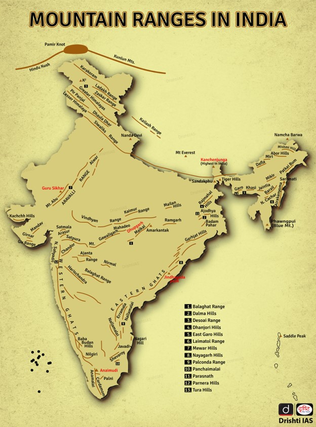
- The Himalayas: The most famous and highest mountain range in India, stretching over 2,900 kilometers along the border between India and Tibet.
- The Himalayas are divided into three main ranges, Himadri (Great Himalayas or Inner Himalayas), Himachal (Lesser Himalayas), Shiwaliks (Outer Himalayas).
- Mount Everest (Sagarmatha/Chomolungma) is the highest peak in the Himalayas and the world, standing at an elevation of 8,848.86 meters above sea level. Other notable peaks in the range include K2, Kanchenjunga, and Makalu.
- Western Ghats: The Western Ghats (Sahyadri Hills) runs parallel to the western coast of India and has an average elevation of about 1,200 meters.
- The highest peak is Anamudi. The Western Ghats are known for their rich biodiversity and are a UNESCO World Heritage Site.
- The Western Ghats are block mountains formed by the downwarping of land into the Arabian Sea.
- Eastern Ghats: The Eastern Ghats runs parallel to the eastern coast of India. The highest peak is Arma Konda at 1,680 meters.
- Aravalli Range: One of the oldest mountain ranges in the world, stretching for about 800 kilometers across north - western India,. The highest peak is Guru Shikhar at 1,722 meters
- Vindhya Range: The Vindhya range runs across central India and is known for its historical significance. The highest point is Sadbhawna Shikhar at 752 meters.
- The Vindhya Range is located to the south of the Malwa Plateau and runs in an east-west direction, parallel to the Narmada Valley.
- Satpura Range: Located in central India, this range has peaks like Dhupgarh, which is the highest at 1,350 meters.
|
Drishti Mains Question: Explain the process of mountain formation with specific reference to fold mountains and their significance for the Indian subcontinent. |
UPSC Civil Services Examination, Previous Year Questions (PYQ)
Prelims
Q. When you travel in Himalayas, you will see the following: (2012)
- Deep gorges
- U-turn river courses
- Parallel mountain ranges
- Steep gradients causing land sliding
Which of the above can be said to be the evidence for Himalayas being young fold mountains?
(a) 1 and 2 only
(b) 1, 2 and 4 only
(c) 3 and 4 only
(d) 1, 2, 3 and 4
Ans: (d)
Mains
Q. Bring out the causes for more frequent landslides in the Himalayas than in Western Ghats. (2013)
Q.Describe the various causes and the effects of landslides. Mention the important components of the National Landslide Risk Management Strategy. (2021)


