Cyclone Dana | 24 Oct 2024
For Prelims: Cyclone Dana, Bhitarkanika National Park, Storm Surges, North Indian Ocean Region, Monsoon, Atmosphere, Cumulonimbus Clouds, Madden Julian Oscillation (MJO), World Meteorological Organization (WMO), Building Code, Cyclone Warning System, mangroves.
For Mains: Formation of Cyclones, Cyclone Disaster Preparedness and Mitigation
Why in News?
According to the India Meteorological Department (IMD), Cyclone Dana is expected to make landfall as a severe cyclone (wind speed: 89 to 117 kmph) along the Odisha coast near Bhitarkanika National Park and Dhamra Port.
What are Key Facts About Cyclone Dana?
- About:
- Emergence: It is the third cyclone to form in the North Indian Ocean region and the second to make landfall along the Indian coast in 2024 after Cyclone Remal.
- It is the first cyclone in the post monsoon cyclone season.
- Naming of Dana: The World Meteorological Organisation (WMO) states that Cyclone Dana was named by Qatar. In Arabic, "Dana" signifies 'generosity' and also refers to 'the most perfectly sized, valuable, and beautiful pearl.'
- Emergence: It is the third cyclone to form in the North Indian Ocean region and the second to make landfall along the Indian coast in 2024 after Cyclone Remal.
- Reasons for Intense Rainfall:
- Intense Convection: The cyclone is showing intense convection in its western sector, which extends up to the upper layers of the atmosphere.
- Intense convection begins when warm, moist air rises, cools, and expands, causing moisture to condense into water droplets and form clouds.
- As the rising air continues to cool and condense, it forms cumulonimbus clouds, typical of thunderstorms and creates conditions conducive to heavy rainfall
- Warm Moist Air: There is an influx of warm, moist air into the core of the cyclone, which further enhances convection leading to more intense rainfall.
- The influx of warm, moist air helps to maintain and intensify the cyclone and enhances the cyclone's strength which results in intense rainfall over a relatively small area.
- Madden Julian Oscillation (MJO) Influence: Currently, MJO is conducive for convection hence heavy rainfall.
- The MJO is made up of two parts: an enhanced rainfall phase and a suppressed rainfall phase.
- During the enhanced phase, surface winds converge, causing air to rise and create more rainfall. In the suppressed phase, winds converge at the top of the atmosphere, causing air to sink and leading to less rainfall.
- This dipole structure moves west to east in the Tropics, creating more cloudiness and rainfall in the enhanced phase, and more sunshine and dryness in the suppressed phase.
- The MJO is made up of two parts: an enhanced rainfall phase and a suppressed rainfall phase.
- Intense Convection: The cyclone is showing intense convection in its western sector, which extends up to the upper layers of the atmosphere.
What are Key Points About the Naming of Cyclones?
- Historical Evolution: In the late 1800s, the practice began in the Caribbean, naming storms after saints from the Roman Catholic calendar.
- After World War II, the use of female names became common for better organisation in tracking storms.
- Following criticism of gender bias, the naming system was updated in 1979 to include both male and female names, alternating between the two.
- Establishment of Naming System: The practice of naming cyclones in the North Indian Ocean region began in 2000 by the World Meteorological Organization (WMO), a specialised agency of the UN.
- Collaborative Naming Lists: In the North Indian Ocean, a collaborative list of cyclone names was established by Tropical Cyclone Regional Body (TCRB).
- TCRB in the North Indian Ocean is a group of 13 countries namely Bangladesh, India, Maldives, Myanmar, Pakistan, Sri Lanka, Oman, Thailand, Iran, Qatar, Saudi Arabia, United Arab Emirates and Yemen.
- Suggestion Submission Process: Each of the 13 member countries is required to provide 13 suggestions for names to a WMO panel which reviews and finalises the name.
- Global Standardisation: Naming cyclones facilitates easier identification for both the media and the public, helping them follow the cyclone’s progress and potential threats.
- Rotation and Retirement of Names: Names on the cyclone list are rotated periodically, ensuring a fresh selection over time.
- Retired names, typically those associated with deadly or destructive storms, are replaced with new suggestions to avoid negative associations.
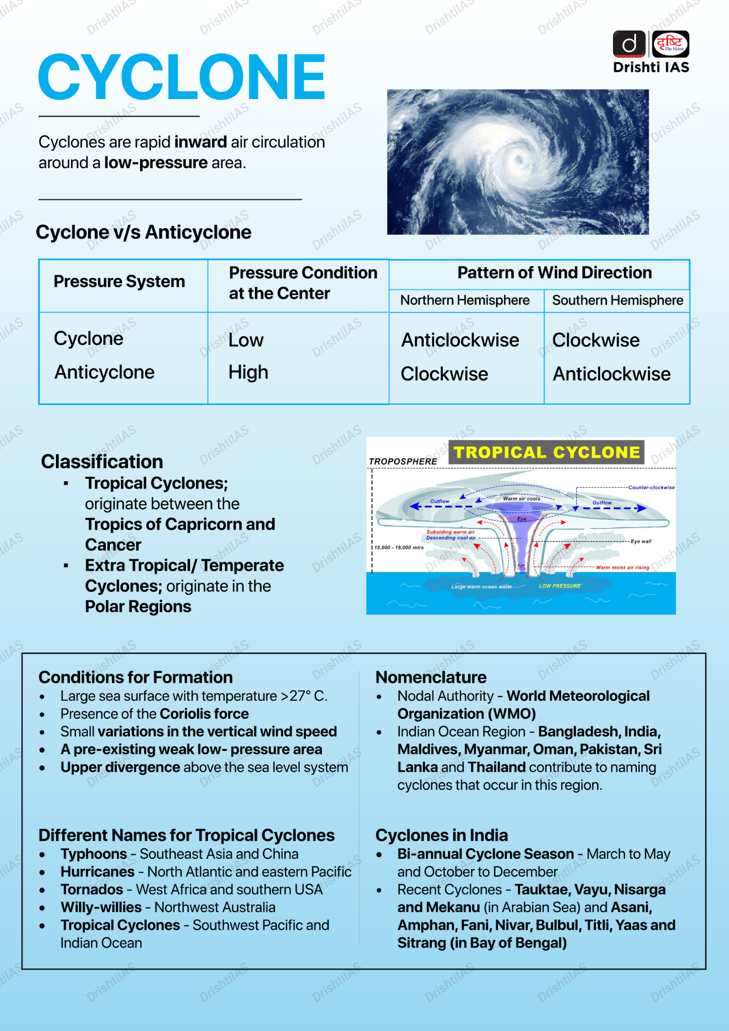
What Factors are Responsible for Formation of Tropical Cyclones?
- Warm Ocean Waters: Sea surface temperatures of at least 27°C are essential for tropical cyclone development. Warm water provides the heat and moisture needed to fuel the storm's rising air and convection process.
- Coriolis Force: The Coriolis effect, caused by Earth's rotation, is necessary to give the cyclone its spin. This force is weak near the equator, so tropical cyclones generally form at least 5° north or south of the equator .
- Low Wind Shear: Low vertical wind shear (the difference in wind speed and direction at different altitudes) is crucial. High wind shear can disrupt the vertical structure of the storm, preventing it from strengthening .
- Pre-existing Disturbance: A tropical disturbance, such as a low-pressure system, provides the initial organisation of air circulation around which a cyclone can form.
- Convergence of Air: The convergence of warm, moist air at the surface, which rises and cools, creating clouds and thunderstorms, is fundamental to developing the cyclone's core.
What are the Impacts of Cyclone?
- Human Impact: Cyclones can cause widespread casualties due to strong winds, storm surges, and flooding. Thousands of people may be evacuated or displaced, leading to temporary or permanent loss of homes.
- Infrastructure Loss: Strong winds can cause power outages and structural damage, while flooding disrupts transportation and communication.
- Environmental Impact: High winds and storm surges erode coastlines, destroying natural habitats and human structures along the shore.
- Cyclones can cause long-term damage to forests, wetlands, and marine ecosystems, affecting biodiversity.
- Agriculture Loss: Low-lying agricultural areas are vulnerable to seawater intrusion and waterlogging from heavy rains, which can destroy crops and reduce agricultural productivity.
- Prolonged rainfall may lead to water accumulation in fields, affecting soil health and damaging crops.
Four-Stage Cyclone Warning System
- Pre-Cyclone Watch (Green): Issued 72 hours in advance. Alerts about potential cyclonic disturbances and expected adverse weather in coastal areas.
- Cyclone Alert (Yellow): Issued at least 48 hours before adverse weather begins. Provides information on the storm’s location, intensity, and advises on safety measures.
- Cyclone Warning (Orange): Issued at least 24 hours before the onset of adverse weather. Offers detailed updates on cyclone position, expected landfall, and associated impacts like heavy rainfall and strong winds.
- Post Landfall Outlook (Red): Issued at least 12 hours before landfall. Detailed adverse weather conditions likely to affect inland areas after landfall.
What Measures are Needed for Effective Cyclone Disaster Preparedness and Mitigation?
- Before Cyclone:
- Land Use Planning: Implement land use and building codes to restrict habitation in vulnerable zones, reserving them for parks or flood diversion.
- Cyclone Early Warning System: Utilise the new Impact-Based Cyclone Warning System to communicate risks and preparedness actions, focusing on local populations and land use patterns.
- Engineered Structures: Build structures designed to withstand cyclone winds, including public infrastructures like hospitals and communication towers.
- Mangrove Plantation: Promote mangrove planting initiatives to shield coastal areas from storm surges and erosion, engaging community participation in these projects.
- During Cyclone:
- Cyclone Shelters: Establish cyclone shelters in high-risk areas and ensure that shelters are connected to major roads for quick evacuation and access during emergencies.
- Flood Management: Implement sea walls, embankments, and drainage systems to control water flow and reduce flooding from storm surges and heavy rainfall.
- After Cyclone:
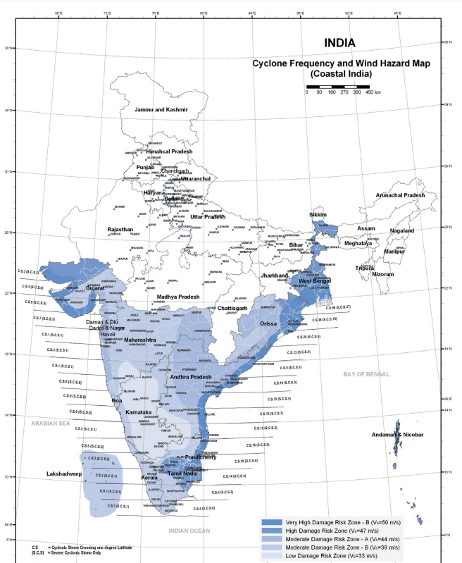
- Hazard Mapping: Create maps that indicate the frequency and intensity of cyclones based on historical data, including storm surges and flooding risks.
- Retrofitting Non-Engineered Structures: Educate communities on retrofitting techniques, such as building steep-slope roofs and anchoring poles, to enhance the resilience of non-engineered homes.
Conclusion
Cyclone Dana underscores the importance of proactive disaster management measures, including effective early warning systems, land use planning, and community involvement. By enhancing infrastructure resilience, implementing hazard mapping, and promoting mangrove conservation, we can better prepare for and mitigate the impacts of cyclones on vulnerable coastal regions.
|
Drishti Mains Question: Discuss the factors contributing to cyclone formation and intensification, along with measures needed for effective disaster preparedness and mitigation. |
UPSC Civil Services Examination Previous Year Question (PYQ)
Prelims
Q. Consider the following statements: (2020)
- Jet streams occur in the Northern Hemisphere only.
- Only some cyclones develop an eye.
- The temperature inside the eye of a cyclone is nearly 10ºC lesser than that of the surroundings.
Which of the statements given above is/are correct?
(a) 1 only
(b) 2 and 3 only
(c) 2 only
(d) 1 and 3 only
Ans: (c)
Q. In the South Atlantic and South-Eastern Pacific regions in tropical latitudes, cyclone does not originate. What is the reason? (2015)
(a) Sea surface temperatures are low
(b) Inter-Tropical Convergence Zone seldom occurs
(c) Coriolis force is too weak
(d) Absence of land in those regions
Ans: (b)
Q.The 2004 Tsunami made people realise that mangroves can serve as a reliable safety hedge against coastal calamities. How do mangroves function as a safety hedge? (2011)
(a) The mangrove swamps separate the human settlements from the sea by a wide zone in which people neither live nor venture out
(b) The mangroves provide both food and medicines which people are in need of after any natural disaster
(c) The mangrove trees are tall with dense canopies and serve as an excellent shelter during a cyclone or tsunami
(d) The mangrove trees do not get uprooted by storms and tides because of their extensive roots
Ans: (d)
Mains
Q.Tropical cyclones are largely confined to the South China Sea, Bay of Bengal and Gulf of Mexico. Why? (2014)
Q. The recent cyclone on the east coast of India was called “Phailin”. How are the tropical cyclones named across the world? Elaborate. (2013)