Uttarakhand Switch to Hindi
Earthquake in Uttarkashi
Why in News?
According to the National Center for Seismology (NCS), an earthquake of magnitude 3.5 on the Richter scale hit Uttarkashi in Uttarakhand.
- The earthquake, which occurred at a depth of 5 km, is part of a sequence of seismic events, with another earthquake of magnitude 4.8 reported earlier in Myanmar.
Key Points
- Uttarkashi and Seismic Sensitivity:
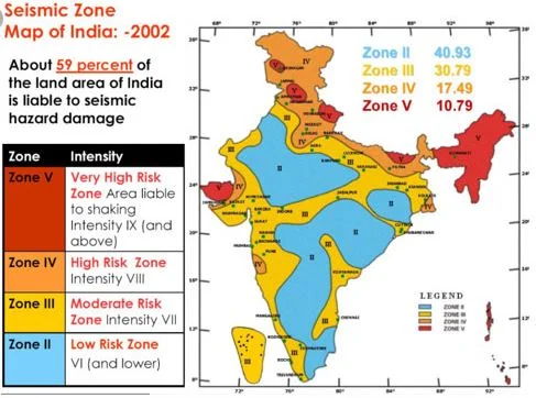
- Uttarkashi is located in the Himalayan seismic belt, making it highly prone to earthquakes.
- The region has previously experienced destructive earthquakes, including the Uttarkashi earthquake (6.8 magnitude) in 1991 and the Chamoli earthquake in 1999.
- Geological Factors and Vulnerability:
- The region is seismically active due to the collision between the Indian Plate and the Eurasian Plate.
- Unchecked construction and deforestation have worsened the situation, increasing the risk of destruction in case of major earthquakes.
- Uttarkashi and surrounding cities like Dehradun, Nainital, and Mussoorie are densely populated, adding to the vulnerability during seismic events.
Earthquake
- About:
- An earthquake is the shaking of the Earth's surface caused by the sudden release of energy beneath the Earth’s crust.
- This natural event generates seismic waves that travel in all directions through the Earth, resulting in ground movement.
- Key Terms Related to Earthquake:
- Hypocenter: The location beneath the Earth’s surface where the earthquake originates.
- Epicenter: The point on the Earth's surface directly above the hypocenter, where the strongest shaking is felt.
- Types of Earthquakes:
- Fault Zones: Earthquakes that occur due to the movement along fault lines in the Earth’s crust.
- Tectonic Earthquakes: Result from the movement of tectonic plates beneath the Earth’s surface.
- Volcanic Earthquakes: Caused by volcanic activity, typically due to the movement of magma beneath the Earth’s surface.
- Human-Induced Earthquakes: Earthquakes triggered by human activities, such as mining or the injection of fluids into the ground.
- Scales of Measuring Earthquakes
- Magnitude Scale:
- The magnitude of an earthquake refers to the amount of energy released. This is measured using the Richter scale, which ranges from 0 to 10, with each number representing a tenfold increase in amplitude. It provides a measure of the earthquake's strength.
- Intensity Scale:
- The intensity of an earthquake refers to the level of shaking experienced and the damage caused. The Mercalli intensity scale, developed by Italian seismologist Giuseppe Mercalli, ranges from 1 to 12, with higher numbers indicating more severe shaking and destruction. ]
- Magnitude Scale:


%20MPPCS%202025%20Desktop%20E.jpg)
%20MPPCS%202025%20Mobile%20E%20(1).jpg)


.png)
.png)


 PCS Parikshan


