

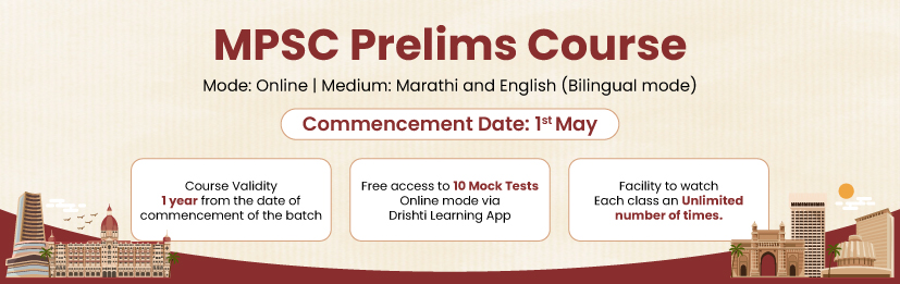
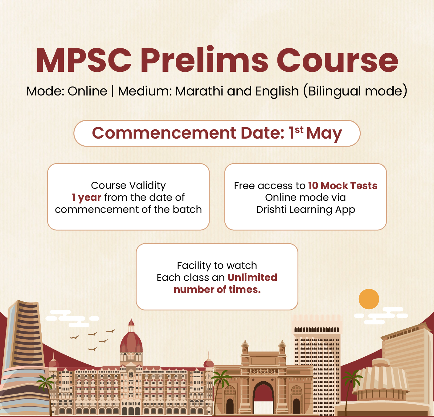
%20MPPCS%202025%20Desktop%20E.jpg)
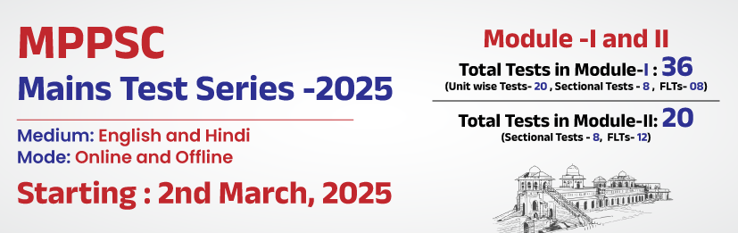
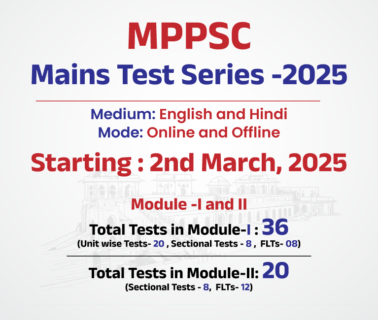
%20MPPCS%202025%20Mobile%20E%20(1).jpg)


.png)
.png)


 PCS Parikshan
Uttarakhand Switch to Hindi
Environmental Approval for Five Years Mining Work in Four Rivers of Uttarakhand
Why In News?
According to information received from media sources on February 23, 2023, on the request of Chief Minister Pushkar Singh Dhami, the Union Ministry of Environment and Forests has approved renovation of four major rivers of Uttarakhand for the next five years.
Key points
- In Uttarakhand, environmental approval has been received for mining work for the next five years in the four major rivers of Kumaon division, Gaula, Sharda, Dabka and Kosi. This will not only provide mining material from the rivers, but also provide employment to 50,000 local people and laborers associated with this business.
- Significantly, when Chief Minister Pushkar Singh Dhami was in Delhi recently, he had raised this issue with the Union Minister. According to the Chief Minister, it is very important for the development of very important infrastructure like civil construction works, expansion of road and rail network, which is necessary religiously and strategically. Availability of RBM will be ensured from these rivers.
- Gaula River
- The Gaula River, known as the Gold Mine in Kumaon, is a Himalayan River that flows through India. The source of this river is Paharpani and the end point is Kichha. The length of this river is about 103 km.
- The Gaula River originates from the Sattal Lake in Uttarakhand. It flows through Kathgodam, Haldwani and Shahi. It then merges with the Ramganga River, a tributary of the Ganga.
- The Gaula catchment has been affected by several landslides as a result of soil erosion and deforestation. Also, there has been a decrease in the water of the springs and overall rainfall over the years, which has reduced its flow. After hitting the ground near Haldwani, the Gaula riverbed is facing soil erosion due to excessive excavation.
- Sharda River
- Sharda River is a Himalayan River also known as 'Kali River', ‘Kutiyangdi’ or 'Mahakali River'. It flows through Uttarakhand.
- The traditional source of the Sharda River is Limpiyadhura in the Pithoragarh district of Uttarakhand, at an altitude of 3,600 m (about 11,800 ft) above sea level.
- The length of this river is 252 km, and the basin area is 18,140 so km. Kali River is the mainstream of Mahakali River.
- Koshi River
- Koshi River, also known as Kosi or Kaushiki, is one of the major and holy rivers of North India. This river is mentioned by the name of Kaushiki in the Manaskhand of Skandpuran.
- It is an important river of the Kumaon region of Uttarakhand. It is a tributary of Ramganga. Kair and Sheesham forests are found on the banks of the river.
- The length of Koshi river is 168 km and its drainage area is spread over an area of about 346 sq km.
- Dabka River
- Dabka River is a stream in Uttarakhand and its height is 1,100 meters.
- Flowing east of the Kosi River, this river emerges from the west of a place called Garampani in Nainital and flows out of the state near Bajpur, flowing through Nainital and Udham Singh Nagar.
Uttarakhand Switch to Hindi
Contract Signed for Construction of Yamunotri Ropeway
Why In News?
On February 23, 2023, in the presence of Chief Minister Pushkar Singh Dhami and Tourism Minister Satpal Maharaj, a contract was signed between the tourism department of the state and the private construction company 'SRM Engineering and FIL Industry Private Limited' for the Yamunotri ropeway project.
Key points
- Proposed 3.38 km from Jankichatti (Kharsali) to Yamunotri Dham. Clearance has already been received from the Forest Ministry for the construction of long ropeway. The ropeway will be operated on PPP mode. About 167 crore rupees will be spent on this ropeway.
- Due to the construction of this ropeway, the devotees going to Yamunotri Dham will get six km. You will not have to climb on foot. You can reach Yamunotri in just 15 to 20 minutes by ropeway. It takes about three hours for the devotees to reach Yamunotri Dham situated at a height of about 11 thousand feet through the Jankichatti (Kharsali) pedestrian route.
- On this occasion, the Chief Minister said that after the completion of the rope-way project, Yamunotri Dham will be connected to its winter residence Kharsali, and the devotees will be able to reach Maa Yamuna easily and take advantage of pollution-free natural beauty. Along with providing facilities to the devotees, the employment resources of the people will increase at the local level as well.
- State Tourism Secretary Sachin Kurve said that this 3.38 km long ropeway to be built on PPP mode will be of monocable detachable type, which will be constructed according to European standards on the lines of France and Switzerland.
- The tourism secretary said that the passenger capacity of this ropeway would be to carry about 500 people in an hour while eight passengers would be able to go in one coach at a time. The lower terminal of the ropeway will be built on 1.787 hectares of land at Kharsali while the upper terminal will be built on 0.99 hectares of land at Yamunotri.


