Uttarakhand Switch to Hindi
Char Dham Yatra 2024
Why in News?
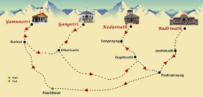
Recently, The ritualistic commencement of the Gangotri shrine began, as the idol of goddess Ganga was transported from her winter abode in Mukhba village to Gangotri.
Key Points
- As per tradition, the ceremony began with prayers of goddess Ganga before placing her on a palanquin and parading her out of the temple.
- The initial group of pilgrims departed from Rishikesh. Various groups were also sent off from different places by religious figures and political leaders.
- The gates of Kedarnath, Gangotri, and Yamunotri will open on Akshay Tritiya (10th May, 2024) , with the Badrinath Dham set to open on 12th May 2024.
Char Dham
- Yamunotri Dham:
- Location: Uttarkashi district.
- Dedicated to: Goddess Yamuna.
- River Yamuna is the second-most sacred river in India after River Ganga.
- Gangotri Dham:
- Location: Uttarkashi district.
- Dedicated to: Goddess Ganga.
- Considered the most sacred of all Indian rivers.
- Kedarnath Dham:
- Location: Rudraprayag district.
- Dedicated to: Lord Shiva.
- Situated on the bank of the Mandakini River.
- One of the 12 Jyotirlingas (divine representations of Lord Shiva) in India.
- Badrinath Dham:
- Location: Chamoli district.
- Home to the sacred Badrinarayan Temple.
- Dedicated to: Lord Vishnu.
- One of the holy shrines for Vaishnavites .
Uttarakhand Switch to Hindi
Early Warning System by IIT-Roorkee Researchers
Why in News?
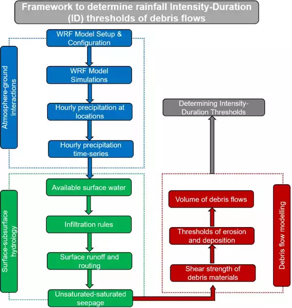
Recently, researchers from IIT-Roorkee have developed a framework to predict landslides in the Himalayan region before they occur by analyzing rainfall patterns, giving at least a six-hour early warning.
Key Points
- This study has been published in a peer-reviewed scientific journal and is considered the first of its kind in India.
- The combined expertise of specialists in various fields like meteorology, hydrology, geomorphology, remote sensing, and geotechnical engineering has led to the creation of a method that combines meteorological modeling with numerical simulations of debris flows.
- Researchers will gather real-time data on rainfall patterns in the hills from weather research agencies.
Landslides
- These are natural disasters occurring mainly in mountainous terrains where there are conducive conditions of soil, rock, geology and slope.
- A sudden movement of rock, boulders, earth or debris down a slope is termed a landslide.
- Causes:
- Natural causes that trigger it include heavy rainfall, earthquakes, snow melting and undercutting of slopes due to flooding.
- They can also be caused by anthropogenic activities such as excavation, cutting of hills and trees, excessive infrastructure development, and overgrazing by cattle.
- Some of the main factors that influence landslides are lithology, geological structures like faults, hill slopes, drainage, geomorphology, land use and land cover, soil texture and depth, and weathering of rocks.
- All these are factored in when a landslide susceptibility zone is earmarked for planning and making predictions.


%20MPPCS%202025%20Desktop%20E.jpg)
%20MPPCS%202025%20Mobile%20E%20(1).jpg)


.png)
.png)


 PCS Parikshan


