


.jpg)
.jpg)


.png)
.png)


Uttar Pradesh Switch to Hindi
Ganga Crosses Warning Mark in Kashi
Why in News?
The Ganga River in Varanasi has surpassed the warning level, causing significant flooding and affecting over 4,000 residents in the region.
- The water level rose to 70.76 meters, surpassing the warning threshold of 70.26 meters; increasing at a rate of 5 cm per hour.
Key Points
- Impact on Residents:
- Affected Population: A total of 4,461 people have been impacted by the floods. Several low-lying areas in the district are now submerged, forcing residents to use boats for commuting.
- Relocation: Families from Mokalpur affected by erosion have been relocated to relief camps. Additionally, 1,601 people from 299 families are currently residing in these camps.
- Relief Measures:
- Flood Relief Camps: The district administration has set up 46 flood relief camps, with 14 currently operational.
- These camps provide essential supplies such as food, fruits, milk, and drinking water. Medical camps have also been established to offer healthcare services.
- Rescue Operations: A total of 22 boats have been deployed for rescue operations.
- Teams from the National Disaster Response Force (NDRF) are actively involved in relief efforts using motorboats.
- Flood Relief Camps: The district administration has set up 46 flood relief camps, with 14 currently operational.
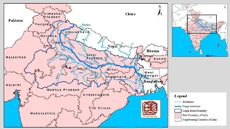
Ganga River System
- The Ganga originates as Bhagirathi from Gangotri Glacier, Uttarakhand at an elevation of 3,892 m.
- Many small streams comprise the headwaters of the Ganga. The important among these are Alaknanda, Dhauliganga, Pindar, Mandakini and Bhilangana.
- At Devprayag, where Alaknanda joins Bhagirathi, the river acquires the name Ganga. It traverses 2525 km before flowing into the Bay of Bengal.
- The Ganga is formed from the 6 headstreams and their five confluences.
- Devprayag: Confluence of Bhagirathi river and Alaknanda river.
- Rudraprayag: Confluence of Mandakini river and Alaknanda river.
- Nandaprayag: Confluence of Nandakini river and Alaknanda river.
- Karnaprayag: Confluence of Pindar river and Alaknanda river.
- Vishnuprayag: Confluence of Dhauliganga river and Alaknanda river.
- The Bhagirathi, considered to be the source stream, rises at the foot of Gangotri Glacier, at Gaumukh. It finally empties into the Bay of Bengal.
- Major Tributaries of the Ganga River:
- Left Bank Tributaries: Ramganga, Gomti, Ghaghara, Gandak, Burhi Gandak, Koshi, Mahananda.
- Right Bank Tributaries: Yamuna, Tons, Karamnasa, Sone, Punpun, Falgu, Kiul, Chandan, Ajoy, Damodar, Rupnarayan.
- The Ganges River flows through 28 districts in Uttar Pradesh, entering the state from Bijnor. It traverses approximately 1140 kilometers within Uttar Pradesh before merging with the Yamuna at the Triveni Sangam in Prayagraj.
Switch to Hindi


