Uttarakhand
Earthquake in Uttarkashi
- 24 Jan 2025
- 3 min read
Why in News?
According to the National Center for Seismology (NCS), an earthquake of magnitude 3.5 on the Richter scale hit Uttarkashi in Uttarakhand.
- The earthquake, which occurred at a depth of 5 km, is part of a sequence of seismic events, with another earthquake of magnitude 4.8 reported earlier in Myanmar.
Key Points
- Uttarkashi and Seismic Sensitivity:
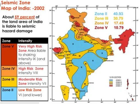
- Uttarkashi is located in the Himalayan seismic belt, making it highly prone to earthquakes.
- The region has previously experienced destructive earthquakes, including the Uttarkashi earthquake (6.8 magnitude) in 1991 and the Chamoli earthquake in 1999.
- Geological Factors and Vulnerability:
- The region is seismically active due to the collision between the Indian Plate and the Eurasian Plate.
- Unchecked construction and deforestation have worsened the situation, increasing the risk of destruction in case of major earthquakes.
- Uttarkashi and surrounding cities like Dehradun, Nainital, and Mussoorie are densely populated, adding to the vulnerability during seismic events.
Earthquake
- About:
- An earthquake is the shaking of the Earth's surface caused by the sudden release of energy beneath the Earth’s crust.
- This natural event generates seismic waves that travel in all directions through the Earth, resulting in ground movement.
- Key Terms Related to Earthquake:
- Hypocenter: The location beneath the Earth’s surface where the earthquake originates.
- Epicenter: The point on the Earth's surface directly above the hypocenter, where the strongest shaking is felt.
- Types of Earthquakes:
- Fault Zones: Earthquakes that occur due to the movement along fault lines in the Earth’s crust.
- Tectonic Earthquakes: Result from the movement of tectonic plates beneath the Earth’s surface.
- Volcanic Earthquakes: Caused by volcanic activity, typically due to the movement of magma beneath the Earth’s surface.
- Human-Induced Earthquakes: Earthquakes triggered by human activities, such as mining or the injection of fluids into the ground.
- Scales of Measuring Earthquakes
- Magnitude Scale:
- The magnitude of an earthquake refers to the amount of energy released. This is measured using the Richter scale, which ranges from 0 to 10, with each number representing a tenfold increase in amplitude. It provides a measure of the earthquake's strength.
- Intensity Scale:
- The intensity of an earthquake refers to the level of shaking experienced and the damage caused. The Mercalli intensity scale, developed by Italian seismologist Giuseppe Mercalli, ranges from 1 to 12, with higher numbers indicating more severe shaking and destruction. ]
- Magnitude Scale:


