Jammu & Kashmir
Army Vehicle Fired Upon in J&K
- 28 Feb 2025
- 3 min read
Why in News?
On 26 February 2025, suspected militants opened fire on an Army vehicle in the Pir Panjal Valley’s Sunderbani sector in Rajouri district. Security forces launched a search operation after the attack in the forest range.
Key Points
- Firing Incident:
- Preliminary reports indicated a brief exchange of fire at Phal village in the Sunderbani sector of Nowshera.
- Gunshots were heard from a nearby forest area as an Army vehicle moved through the region.
- No Casualties Reported:
- Officials confirmed that the incident did not result in any casualties.
- The firing occurred near the Line of Control (LoC).
- Security Response and Search Operation:
- Security forces launched a massive cordon and search operation (CASO) in the nearby pockets of Phal village.
- Rajouri district has previously witnessed infiltration incidents along the LoC.
Line of Control
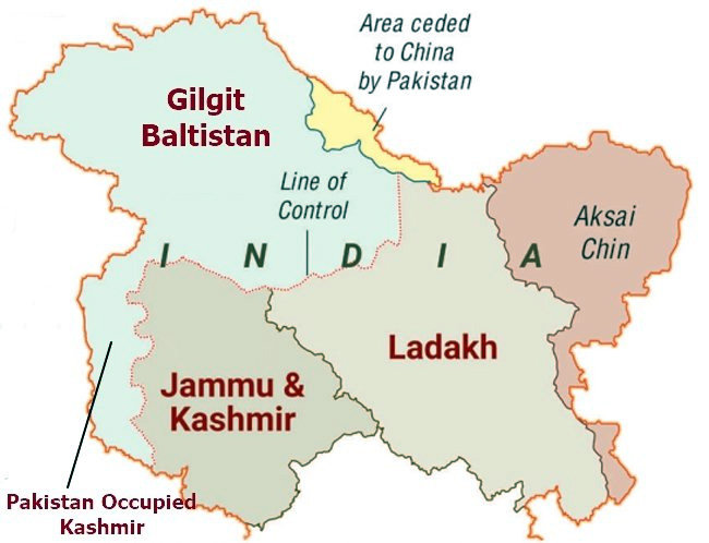
- The Line of Control (LoC) emerged from the 1948 ceasefire line negotiated by the United Nations (UN) after the Kashmir War.
- It was designated as the LoC in 1972, following the Shimla Agreement between the two countries.
- LoC is demarcated up to the Siachen Glacier (Point NJ9842)- the world's highest battlefield.
- LoC is delineated on a map signed by the Director General of Military Operations (DGMO) of both armies and has the international sanctity of a legal agreement.
Pir Panjal
- About:
- The Pir Panjal Range is a mountain range in the northern Indian subcontinent.
- It begins in Ramban and extends westward, lying south of Jammu and Kashmir’s Vale of Kashmir, reaching Muzaffarabad District.
- The range rises sharply to an average elevation of over 13,000 feet (4,000 meters).
- It separates the Jammu Hills in the south from the Vale of Kashmir, beyond which lie the Great Himalayas.
- The range separates from the Himalayas near the banks of the Sutlej River.
- It forms a natural divide between the Beas and Ravi rivers on one side and the Chenab River on the other.
- Major Passes:
- The range has six historical passes, Hajipir Pass, Gulabgarh Pass, Ratanpir Pass, Pir Panjal Pass, Banihal Pass, Bairam Gala Pass.
- Important Peaks:
- Deo Tibba (6,001 m) and Indrasan (6,221 m) are two significant peaks at the eastern end of the range


