-
09 Jan 2025
GS Paper 1
Geography
Day 34: Explain how the interaction between different types of air masses shapes weather patterns. Illustrate with examples. (150 Words)
Approach
- Introduce air masses and their role in influencing weather.
- Explain how interactions between air masses shape weather patterns with relevant examples.
- Conclude suitably.
Introduction
Air masses are large bodies of air with uniform temperature and humidity, formed in specific source regions such as polar, tropical, continental, or maritime areas. These air masses interact along boundaries called fronts, leading to various weather phenomena like rainfall, storms, and cyclones. Their interactions are crucial for shaping daily weather and climatic conditions across the globe.
Body
Interactions of Air Masses and Weather Patterns:
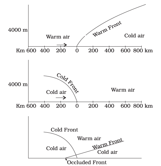
- Cold Fronts:
- Formed when a cold air mass (e.g., continental Polar (cP) or Arctic (cA)) pushes under a warm air mass (e.g., maritime Tropical (mT)), forcing the warm air to rise rapidly.
- This interaction leads to heavy rainfall, thunderstorms, and a significant drop in temperature.
- Example: In the U.S. Midwest, spring tornadoes and storms are caused by Arctic air (cA) colliding with tropical air (mT).
- Warm Fronts:
- Occur when a warm air mass overtakes a cold air mass, resulting in the warm air rising gently over the cold air.
- This produces light to moderate rainfall and overcast skies that persist over a longer duration.
- Example: Warm fronts originating in the North Atlantic bring rain and fog to the United Kingdom.
- Stationary Fronts:
- Form when two air masses meet but neither advances significantly.
- This results in extended periods of cloud cover and steady rainfall.
- Example: Stationary fronts along the Gulf Coast often lead to flash flooding events.
- Occluded Fronts:
- Occur when a cold front overtakes a warm front, lifting the warm air completely above the surface.
- This interaction is associated with intense cyclonic activity and heavy precipitation.
- Example: Mid-latitude cyclones in Europe are often driven by occluded fronts formed by maritime Polar (mP) and continental Polar (cP) air masses.
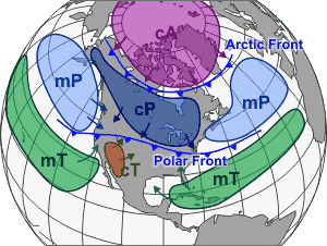
Role in Extreme Weather Events:
- Tropical Cyclones and Hurricanes:
- Warm, moist air masses (e.g., maritime Tropical (mT)) serve as energy sources for tropical cyclones.
- Example: Cyclone Fani (2019) in the Bay of Bengal was fueled by mT air, causing widespread devastation.
- Cold Waves:
- Polar air masses (e.g., continental Polar (cP)) moving into temperate regions cause severe cold waves and sub-zero temperatures.
- Example: Polar Vortex events in North America often bring harsh winter conditions.
Conclusion
The interaction of air masses is a fundamental factor shaping weather patterns, ranging from daily conditions to extreme events. Understanding these interactions helps in accurate forecasting, disaster preparedness, and mitigating the impacts of climate variability, thus enhancing resilience at local and global levels.


