-
02 Apr 2025
GS Paper 2
Geography & Economy
Day 27: Describe the major physiographic divisions of Bihar and their distinguishing geographical features. (38 marks)
Approach:
- Introduce by mentioning the location and Geography of Bihar.
- Highlight the major physiographic divisions of Bihar.
- Conclude suitably.
Introduction:
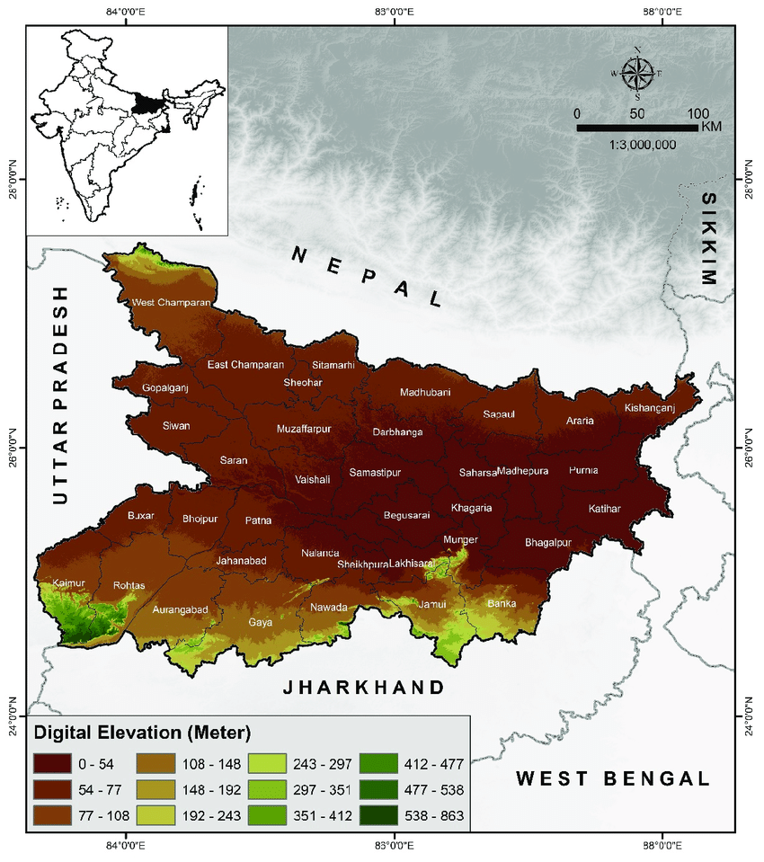
Bihar, located between 24° 20’ 10” N to 27° 31’ 15” N latitudes and 83° 19’ 50’’ E to 88° 17’ 40’’ E longitudes, spans an area of 94,163 sq. km, making it the 12th largest state in India. Its physical landscape is classified into three major physiographic divisions, each with distinct geological and topographical characteristics that influence Bihar’s natural and economic profile.
Body:
- Shiwalik Ranges and Terai Region:
- Located in the northwestern part of West Champaran, this region is the only hilly zone in Bihar.
- Spanning 932 sq. km, it represents the Tertiary Rock System and is part of the outer Himalayas.
- This division includes the Ramnagar Doon, Someshwar Ranges, and Harha Valley (Doon Valley).
- The region has steep slopes, dense forests, and seasonal streams, with relatively sparse human habitation.
- It plays a crucial role in ecological balance and forms a transition zone between the Himalayas and the plains.
- The Ganga Plains (Middle Gangetic Plains):
- This is the most dominant region, covering about 45,000 sq. km, or nearly 50% of Bihar’s area.
- It stretches from the Terai in the north to the southern plateau, and from West Champaran to Katihar.
- Formed by alluvial deposits from rivers like Ganga, Gandak, Ghaghara, Bagmati, Kosi, Son, and others.
- It consists of new (Khadar) and old (Bangar) alluvium, making the soil extremely fertile and suited for agriculture.
- This region is densely populated, agriculturally productive, and forms the heartland of Bihar’s economy.
- Southern Plateau Region:
- Located between the Southern Plains and Chhotanagpur Plateau, from Kaimur in the west to Banka in the east.
- Composed mainly of igneous and metamorphic rocks like Granite, Gneiss, and Schist, making it geologically stable.
- Features isolated conical hills such as Pretshila, Ramshila, and Jethian Hills, which are batholithic in origin.
- Rich in mineral resources like quartzite, mica, and bauxite, though industrial exploitation is still limited.
- The region is relatively less populated and features undulating terrain, with scope for forestry and mining development.
Conclusion:
The three physiographic divisions of Bihar—the Shiwalik-Terai hills, the fertile Ganga Plains, and the mineral-rich Southern Plateau—together shape the state’s agro-economic diversity, population distribution, and natural resource potential. While the plains support intensive agriculture and dense settlement, the plateau offers mining prospects and the hilly terrain contributes to ecological sustainability. Understanding these divisions is crucial for regional planning and sustainable development in Bihar.


