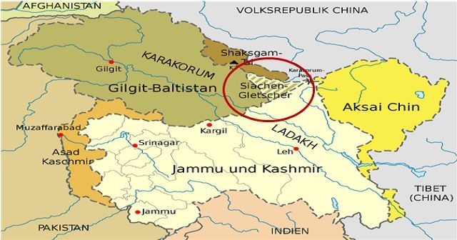
Siachen Glacier | 15 Jul 2023
For Prelims: Siachen Glacier, Geological Survey of India (GSI), Operation Megh Doot in 1984, Karachi Ceasefire Agreement, Simla Agreement.
For Mains: Siachen Glacier.
Why in News?
NJ 9842 is the known boundary between India and Pakistan, but fewer know about 5Q 131 05 084, the number assigned to the Siachen Glacier by the Geological Survey of India (GSI), a disputed area between the two countries since 1984.
- The point NJ 9842 as it is the last mutually demarcated point between India and Pakistan as per the Karachi ceasefire agreement of 1949 and also the point where the Line of Control of the Simla Agreement ends.
What is the First GSI Survey of Siachen Glacier?
- GSI Survey:
- The first GSI survey of the Siachen Glacier was conducted in June 1958 by an Assistant Geologist V. K. Raina, with the GSI. The survey aimed to study the Himalayan glacier systems as part of the International Geophysical Year activities.
- The GSI team spent nearly three months camping at the base of the glacier, conducting various studies and establishing survey points.
- Significance for India:
- The survey holds significance for India as it marks the official Indian exploration of the Siachen Glacier, an area that would later become a bone of contention between India and Pakistan.
- The peaceful environs surveyed in 1958 turned into a conflict zone when India launched Operation Meghdoot in 1984 to secure its presence in the region.
- The GSI survey provides historical evidence of India's early knowledge and scientific engagement with the glacier, countering any claims of Pakistani control since the beginning.
- Pakistan’s Claims:
- Initially, during the GSI survey in 1958, Pakistan did not raise any protests or objections to the Indian presence on the glacier. This could be attributed to both countries abiding by the terms of the Karachi ceasefire agreement of 1949, which had delineated the ceasefire line up to the glaciers and called for mutual demarcation.
- However, Pakistan's lack of interest in scientific visits and explorations in the region might have also played a role.
- It was only 25 years later, in August 1983, that Pakistan unilaterally extended the Line of Control (LOC) from NJ 9842 till the Karakoram Pass in its protest notes, challenging the status quo.
- This moves raised concerns in India, leading to the pre-emptive occupation of the strategic Saltoro Heights by Indian forces in April 1984.
- Pakistan's claims and actions since then have been based on differing interpretations of historical agreements, such as the Karachi ceasefire agreement and the Simla Agreement.
What is Siachen Glacier?
- The Siachen Glacier is located in the Eastern Karakoram range in the Himalayas, just northeast of Point NJ9842 where the LOC between India and Pakistan ends.
- The entire Siachen Glacier, with all major passes, has been under the administration of India since 1984 (Operation Meghdoot).
- The Siachen Glacier is positioned from northwest to southeast. It originates at the base of the Indira Col West, a col (low point) on the Indira Ridge, at an altitude of 6,115 metres, and it descends to an altitude of 3,570 metres.
- It is the Second-Longest glacier in the World's Non-Polar areas after Fedchenko Glacier in Tajikistan.
- The Siachen Glacier lies immediately south of the great drainage divide that separates the Eurasian Plate from the Indian subcontinent in the extensively glaciated portion of the Karakoram sometimes called the "Third Pole".
- Nubra river originates from Siachen Glacier.
- The Siachen Glacier is the world's highest battlefield.
UPSC Civil Services Examination, Previous Year Questions (PYQs)
Q. Siachen Glacier is situated to the (2020)
(a) East of Aksai Chin
(b) East of Leh
(c) North of Gilgit
(d) North of Nubra Valley
Ans: (d)

