Shifting of Route of the Silk Road | 17 Jun 2024
For Prelims: Climate Change, Silk Route, Belt and Road Initiative (BRI), China-Pakistan Economic Corridor (CPEC)
For Mains: Impact of Climate Change, China-Pakistan Economic Corridor and its implications on India.
Why in News?
A recent study by Chinese scientists published in the journal Science Bulletin, found that the main route of the ancient Silk Road shifted northward due to climate change.
- The study provides a valuable case study for examining the relationship between climate change and the spatial evolution of human societies.
What is the Silk Road?
- About:
- The Silk Road was a vast network of trade routes that connected the Atlantic seaboard of Europe with the Pacific coast of Asia (China), spanning over 1,500 years of history.
- It was named for the lucrative silk trade that was established in China at the far eastern end of the trade route.
- Besides silk, the route was also used to transport other goods such as spices, gold, and precious stones.
- Route:
- Along the way, it passed through a number of important cities and kingdoms, including Samarkand, Babylon, and Constantinople.
- History:
- In the 2nd century BCE, Emperor Wu of the Chinese Han Dynasty dispatched his diplomat Zhang Qian to the "Western Regions" (Xinjiang and beyond).This led to the gradual establishment of the Tarim Basin route of the Silk Road.
- Zhang Qian is credited as the "Father of the Silk Road" for his pioneering expedition.
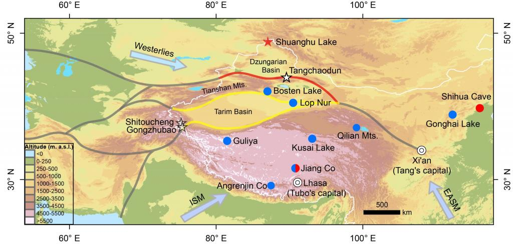
- Caravans travelling from China's capital Xian or towards it used the Tarim Basin route, which skirted the basin enclosed by the Tianshan, Kunlun, and Pamir mountains and within the basin lies the Takla Makan Desert.
- After travelling around the Tarim Basin, the caravans would head west towards the Levant (modern-day Syria, Jordan, the Holy Land, and Lebanon) and Anatolia, where the goods would be transferred to ships in Mediterranean ports, and then further westward to Western Europe.
- This route facilitated the flow of goods, people, ideas, religions, and even diseases between the opposite ends of Eurasia and played a crucial role in the cultural and economic exchange between the civilisations of Europe and Asia.
- In the 2nd century BCE, Emperor Wu of the Chinese Han Dynasty dispatched his diplomat Zhang Qian to the "Western Regions" (Xinjiang and beyond).This led to the gradual establishment of the Tarim Basin route of the Silk Road.
How the Route of Silk Road was Shifted?
- Old Route (Tarim Basin Route):
-
The original main route of the Silk Road went around the Tarim Basin which lies between the Tianshan Mountains to the north and the Kunlun Mountains to the south.
-
The merchants chose this route in order to avoid the harsh desert conditions of the Tarim Basin.
-
-
New Route (Junggar Basin Route):
- During the period of around 420–850 CE, the caravans no longer followed the traditional route around the Tarim Basin on the Silk Road.
- Instead, they started using the northern slopes of the Tianshan Mountains (in Junggar Basin in modern-day Xinjiang), historically called Dzungaria.
- This "New Northern" route eventually replaced the Tarim Basin route entirely.
-
Consequences of the New Route:
- It fostered the development of the Turco-Sogdian cultural sphere.
- It facilitated communication and trade between Chinese dynasties and nomadic empires in Central and West Asia, like the Khazar Empire.
- This shift improved communication and trade across Eurasia, connecting the Pacific and Atlantic regions.
- During the period of around 420–850 CE, the caravans no longer followed the traditional route around the Tarim Basin on the Silk Road.
What were the Reasons Behind the Shift of the Silk Road?
- Climate Change:
- Researchers used chironomid (‘lake flies’) fossils to reconstruct past climate and found a period of cooling and drying (420-600 CE) in the Tarim Basin, which means the region experienced colder temperatures and less precipitation (climate change) during that time.
- The decline in meltwater and precipitation in the Tarim Basin made the traditional route less viable due to water scarcity. Thus caravans switched to the northern route along the Tianshan mountains because it offered more abundant and stable water resources.
- Researchers used chironomid (‘lake flies’) fossils to reconstruct past climate and found a period of cooling and drying (420-600 CE) in the Tarim Basin, which means the region experienced colder temperatures and less precipitation (climate change) during that time.
- Geopolitical Factors:
- Even after the climate in the Tarim Basin improved (warmer and wetter between 600-850 CE), the trade route remained on the northern Junggar Basin route.
- This is due to the rise of the Tubo Kingdom (Tibet) south of Xinjiang, whose expanding power clashed with China's Tang Dynasty, making the traditional Tarim Basin route potentially less safe or politically favourable for trade.
What was the Historical Significance of the Silk Route?
- Economic Significance:
- The Silk Road served as the main trade route, enabling the trade of high-end products such as silk, spices, valuable metals, and gemstones between China, India, Persia, Arabia, and the Mediterranean.
- This generated considerable wealth and prosperity, playing a role in the economic advancement and progress of the societies situated along this ancient network.
- Cultural Diffusion:
- The Silk Route facilitated the exchange of cultural, artistic, and religious ideas between the East and the West, leading to the spread of Buddhism, Christianity, Islam, and other beliefs. It also enabled the transfer of technologies, agricultural practices, and artistic traditions.
- This exchange promoted the blending of cultures, languages, and knowledge, enriching cultural heritage and contributing to a diverse and interconnected world.
- Geopolitical Significance:
- The Silk Route was a crucial network of trade routes, granting power and influence to controlling empires. Securing it led to military outposts, fortifications, and diplomatic ties.
- Competition for control shaped Eurasia's geopolitical landscape, influencing the rise and fall of civilizations for centuries.
- Technological Advancements:
- The Silk Route enabled the exchange of technological innovations like the compass, gunpowder, and printing between East and West.
- It also spurred the development of advanced transportation methods, including camel caravans and maritime shipping.
- Legacy and Contemporary Relevance:
- The Silk Route continues to impact modern trade and cultural exchanges, with initiatives like the Belt and Road Initiative highlighting its importance in current economic and geopolitical dynamics.
How did the Silk Route End, and What are the Revival Efforts in Present Times?
- End of Silk Route:
- The original Silk Route disappeared in 1453 when the Ottoman Empire closed off trade with the West, leading to the separation of East and West. Alternative sea routes were later discovered for more efficient East-West trade.
- Reviving the Silk Route:
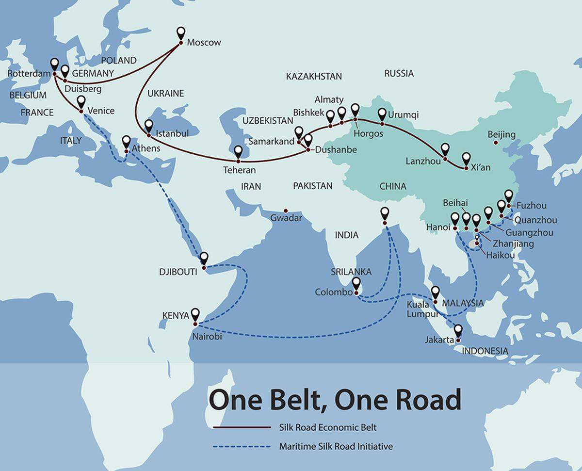
- In 2013, China initiated the "One Belt, One Road" (OBOR) or Belt and Road Initiative strategy to revive the Silk Route.
- It aims to enhance connectivity with over 60 countries across Asia, Europe, and East Africa.
What is the Belt and Road Initiative (BRI)?
- About:
- It represents a multifaceted development strategy aimed at enhancing global connectivity and cooperation.
- It was launched in 2013 and aims to link Southeast Asia, Central Asia, the Gulf region, Africa and Europe with a network of land and sea routes.
- Objectives:
- It aims to boost international connectivity by enhancing infrastructure, trade, and economic cooperation.
- Routes of BRI:
-
Silk Road Economic Belt:
- This segment of the BRI is dedicated to improving connectivity, infrastructure, and trade links across Eurasia through a network of overland transportation routes.
- Maritime Silk Road:
- This component emphasises maritime connections and cooperation in the form of ports, shipping routes, and maritime infrastructure projects.
- It begins via the South China Sea going towards Indo-China, South-East Asia and then around the Indian Ocean thus reaching Africa and Europe.
- This component emphasises maritime connections and cooperation in the form of ports, shipping routes, and maritime infrastructure projects.
-
- Geographic Corridors:
- The land-based Silk Road Economic Belt envisions 6 key corridors for development:
- China-Pakistan Economic Corridor (CPEC).
- New Eurasian Land Bridge Economic Corridor.
- China-Indochina Peninsula Economic Corridor.
- China-Mongolia-Russia Economic Corridor.
- China-Central Asia-West Asia Economic Corridor.
- China-Myanmar Economic Corridor.
- The land-based Silk Road Economic Belt envisions 6 key corridors for development:
|
Drishti Mains Question: How is China's revival of the ancient silk route through the BRI changing the region's geopolitics? Evaluate the impact. |
UPSC Civil Services Examination Previous Year Question (PYQ)
Prelims
Q. Belt and Road Initiative is sometimes mentioned in the news in the context of the affairs of (2016)
(a) African Union
(b) Brazil
(c) European Union
(d) China
Ans: (d)
Mains
Q1. The China-Pakistan Economic Corridor (CPEC) is viewed as a cardinal subset of China’s larger ‘One Belt One Road’ initiative. Give a brief description of CPEC and enumerate the reasons why India has distanced itself from the same. (2018)
Q2. “China is using its economic relations and positive trade surplus as tools to develop potential military power status in Asia”. In the light of this statement, discuss its impact on India as her neighbour. (2017)


