Regional Rapid Transit System (RRTS) | 08 Jun 2024
For Prelims: Regional Rapid Transit System (RRTS), Smart Cities, AMRUT Mission, Swachh Bharat Mission-Urban, HRIDAY, Pradhan Mantri Awas Yojana-Urban, Aspirational district program.
For Mains: Key features of the Regional Rapid Transit System (RRTS , advantages of RRTS with relevant geographical theories.
Why in News?
- Currently, the National Capital Region Transport Corporation (NCRTC) is developing 900 rainwater harvesting (RWH) pits along the Delhi-Ghaziabad-Meerut Regional Rapid Transit System (RRTS) corridor in a move to ensure environmental sustainability.
What is Rainwater Harvesting?
- Rainwater Harvesting & Conservation is the activity of direct collection of rainwater. The rainwater collected can be stored for direct use or can be recharged into the Groundwater.
- There are two main techniques of rainwater harvesting:
- Storage of rainwater on surface for future use.
- Recharge to groundwater.
How do the RRTS Pits Capture and Store Rainwater?
- The pits are strategically placed for maximum water collection and over 75% of these systems are already operational.
- The pits are expected to recharge millions of cubic meters of groundwater, contributing significantly to water table levels.
- The design consists of two small water chambers constructed face-to-face underground, connected by a central rainwater harvesting pit.
- During rainfall, water flows from the viaduct (bridge-like structure) into these chambers The collected water is filtered through three layers of gravel and sand before being absorbed into the ground through the central pit.
- The depth of the pits varies between 16 and 22 meters, depending on the local groundwater level.
- Rainwater harvesting is also being incorporated at each RRTS station, with two pits being built near every entry and exit gate.
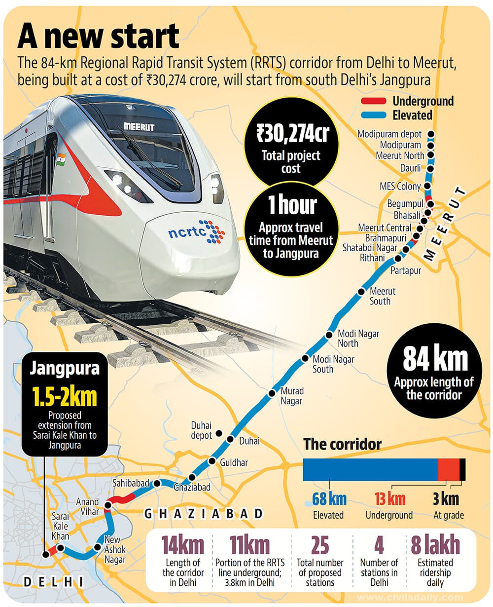
What are the Key Facts Regarding the RRTS?
- Background:
- In 2005, a government task force was formed to create a comprehensive transportation plan for the Delhi National Capital Region (NCR).
- This plan called the Integrated Transport Plan for NCR 2032, identified a need for a special rapid transit system to connect major cities within the region.
- The task force identified 8 corridors and prioritized three corridors for this "Regional Rapid Transit System" (RRTS): Delhi-Meerut, Delhi-Panipat, and Delhi-Alwar.
- About RRTS:
- RRTS is a brand-new mode of public transportation designed specifically for the NCR.
- Delhi-Meerut corridor RRTS is a rail-based,semi-high-speed, high-frequency commuter transit system.
- The Delhi-Ghaziabad-Meerut corridor has a total length of 82-km long, with 22 stations.
- Advantages of RRTS:
- High Speed & Capacity: Unlike traditional railways or metros, RRTS trains will travel at much faster speeds (over 160 km/h) and carry a large number of passengers, reducing congestion, high-frequency operations with trains every 15 minutes.
- Dedicated Corridor: RRTS trains operate on a separate, elevated track, free from traffic congestion on roads, ensuring reliable travel times.
- Environmental Impact: RRTS is estimated to significantly reduce air pollution in the region, by encouraging more people to use public transportation
- Economic Growth: Improved connectivity will lead to more balanced economic development across the NCR, creating opportunities in various cities and reducing reliance on a single central hub.
- Sustainable Future: RRTS serves as a model for developing efficient public transport systems in other Indian cities. It will also help reduce overall traffic congestion and emissions within the NCR.
What are the Geographical Theories associated with RRTS?
- Central Place Theory:
-
This theory suggests settlements (cities) develop around central locations that provide services to surrounding areas.
-
RRTS connects smaller towns and suburbs to major cities, allowing for easier access to jobs, education, and other services offered in the central city.
- For example, The Delhi-Meerut RRTS connects Delhi, a major economic hub, with Meerut, a developing city. This improves access for Meerut residents to Delhi's opportunities like jobs, education, and other services offered in the central city of Delhi.
-

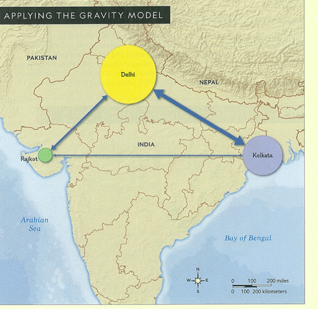
- Gravity Model:
-
This model suggests the interaction between two places is influenced by their populations and the distance between them.
-
RRTS strengthens this by facilitating faster and more frequent travel, thus increasing the potential for economic and social interaction between connected cities. This can lead to increased trade, collaboration, and cultural exchange.
-
-
-
Diffusion Theory:
-
This theory explains how ideas, innovations, and practices spread across space. RRTS can lead to the spread of urban development patterns (shopping malls, business districts) along the train corridor.
- For Example, The Delhi-Ghaziabad RRTS could lead to the development of new commercial centres in Ghaziabad, previously a primarily residential area.
-
What are India’s Initiatives for Urban Transportation?
Conclusion
The Delhi-Meerut RRTS project, as a whole, embodies a future-oriented approach to urban development. By prioritizing sustainable practices like rainwater harvesting, the NCRTC sets a positive example for infrastructure projects across India. This commitment to environmental responsibility goes hand-in-hand with the project's aim to provide a high-speed, reliable, and efficient public transportation system, ultimately contributing to a cleaner and more livable NCR.
|
Drishti Mains Question: Q. Highlighting the key features of the Regional Rapid Transit System (RRTS) , discuss the advantages of RRTS with relevant geographical theories. |
UPSC Civil Services Examination, Previous Year Questions (PYQs)
Prelims
Q. With reference to the Indian economy after the 1991 economic liberalisation, consider the following statements: (2020)
- Worker productivity (Rs. per worker at 2004-05 prices) increased in urban areas while it decreased in rural areas.
- The percentage share of rural areas in the workforce steadily increased.
- In rural areas, the growth in the non-farm economy increased.
- The growth rate in rural employment decreased.
Which of the statements given above is/are correct?
(a) 1 and 2 only
(b) 3 and 4 only
(c) 3 only
(d) 1, 2 and 4 only
Ans: (b)
Mains
Q. The frequency of urban floods due to high-intensity rainfall is increasing over the years. Discussing the reasons for urban floods, highlight the mechanisms for preparedness to reduce the risk during such events. (2016)