Mt. Merapi of Indonesia | 23 Jun 2020
Why in News
Mount Merapi, an active volcano in Indonesia, erupted twice on 21st June, 2020.
Key Points
- Mt Merapi:
- Merapi (Mountain of Fire) is the most active of Indonesia’s 130 active volcanoes.
- It rises to 2,911 metres and has steep slopes with dense vegetation on its lower sides.
- It is located near the centre of the island of Java and Indonesia’s cultural capital, Yogyakarta.
- Mt Merapi’s last significant eruption was in 2010. At that time, more than 300 people were killed and some 2,80,000 residents were forced to evacuate the surrounding areas.
- Volcanoes in Indonesia:
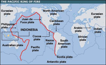
- Indonesia is located on the Pacific Ring of Fire.
- The Ring of Fire, also referred to as the Circum-Pacific Belt, is a path along the Pacific Ocean characterized by active volcanoes and frequent earthquakes.
- Its length is approximately 40,000 kilometers. It traces boundaries between several tectonic plates—including the Pacific, Cocos, Indian-Australian, Nazca, North American, and Philippine Plates.
- 75% of Earth’s volcanoes i.e. more than 450 volcanoes are located along the Ring of Fire. 90% of Earth’s earthquakes occur along its path, including the planet’s most violent and dramatic seismic events.
- The abundance of volcanoes and earthquakes along the Ring of Fire is caused by the amount of movement of tectonic plates in the area.
- Along much of the Ring of Fire, plates overlap at convergent boundaries called subduction zones. That is, the plate that is underneath is pushed down, or subducted, by the plate above. As rock is subducted, it melts and becomes magma. The abundance of magma so near to Earth’s surface gives rise to conditions ripe for volcanic activity.
- A significant exception is the border between the Pacific and North American Plates. This stretch of the Ring of Fire is a transform boundary, where plates move sideways past one another. This type of boundary generates a large number of earthquakes as tension in Earth’s crust builds up and is released.

