Massive Mountains Discovered under Earth’s Crust | 18 Feb 2019
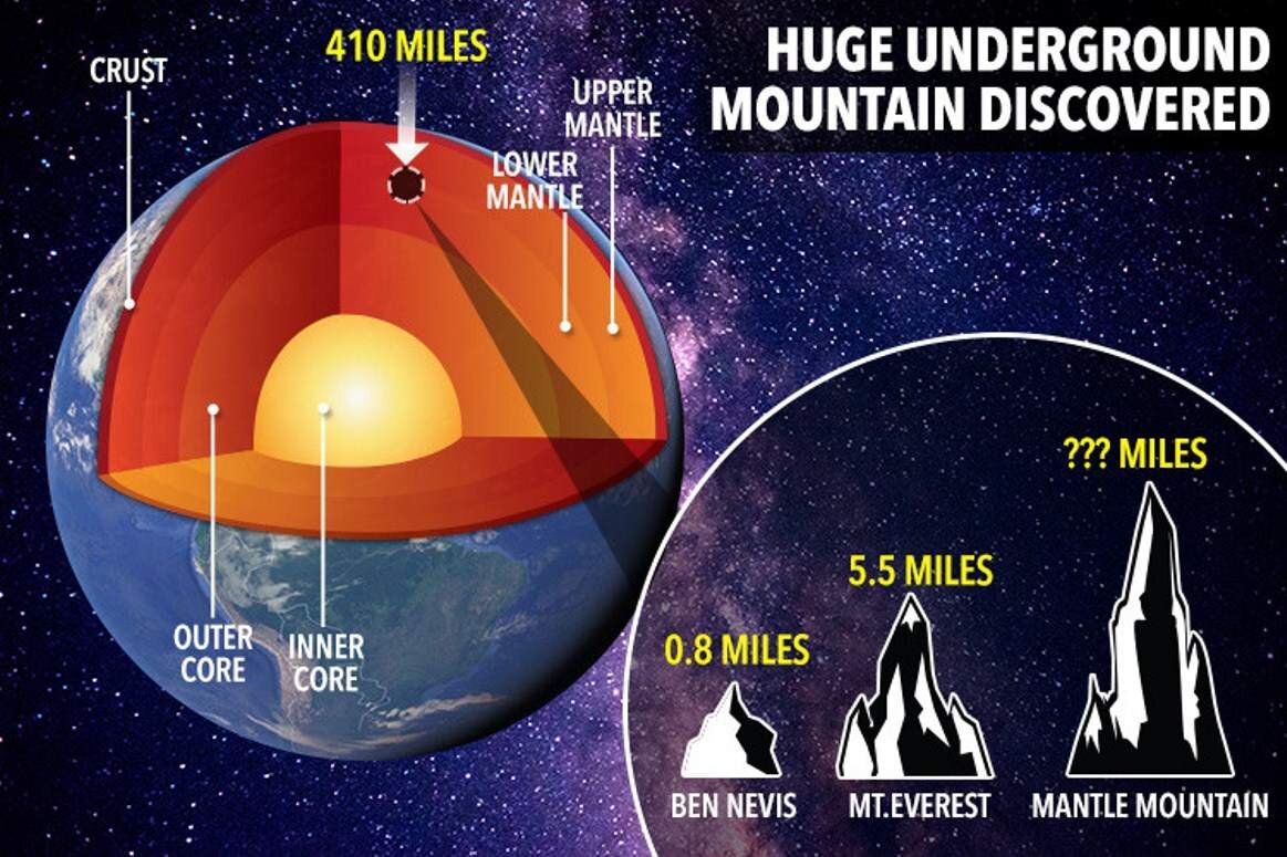
Scientists have discovered massive mountains in the Earth’s mantle.
- The mountains were located at the boundary of the outer and lower mantle at a depth of 660 km.

- Lacking a formal name for this layer, the researchers simply call it “the 660-km boundary.”
How it was Discovered?
- Scientists have used the earthquake data from the 8.2 magnitude earthquake which shook Bolivia in 1994.
- This earthquake was the second-largest deep earthquake ever recorded, with a focal point estimated at a depth of 650 kilometers.
- This earthquake was also the first big earthquake to be measured on a modern seismic network, providing researchers with unprecedented data.
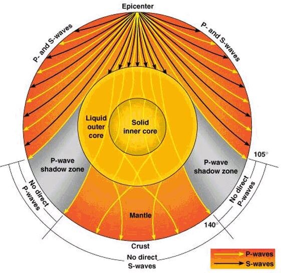
- Data was gathered from earthquakes waves that travel in all directions and can travel through the core to the other side of the planet.
Findings
- From earthquake waves, the researchers came to know that the upper and lower mantle boundary at 660 km depth is rough.
- The researchers also examined a layer 410 km down, at the top of the mid-mantle “transition zone,” and the surface is not similarly rough.
Significance
- Due to technical limitations, scientists were not able to determine the height of these mountains, but there’s a chance that these mountains are bigger than anything on the surface of the Earth.
- This discovery is also important for understanding how the earth formed and continues to function.
Interior of the Earth
- The Earth has three layers: a crust, mantle, and core, which is subdivided into an inner and outer core.
Information about Interior of the Earth
- There are two sources of information for scientists about the interior of the earth: Direct and Indirect.
- Direct Sources
- Surface rock or the rocks from mining.
- Deep Ocean Drilling Projects: The deepest drill is at Kola, in the Arctic Ocean, which has reached a depth of 12 km.
- Volcanic eruptions.
- Indirect Sources
- Meteors from space.
- Gravitation, magnetic field.
- Seismic activity: Seismic activity is one of the most important sources of information about the interior of the earth.
Earthquake
- An earthquake in simple words is shaking of the earth. It is a natural event. It is caused due to the release of energy, which generates waves that travel in all directions.
- Focus and Epicenter
- The release of energy occurs along a fault. The point where the energy is released is called the focus of an earthquake.
- The energy waves traveling in different directions reach the surface of the earth. The point on the surface, nearest to the focus, is called Epicenter.
- Earthquake Waves

- Earthquake waves are basically of two types — body waves and surface waves.
- Body waves
- Body waves are generated due to the release of energy at the focus and move in all directions traveling through the body of the earth. Hence, the name body waves.
- There are two types of body waves. They are called P and S-waves.
- P-waves: P-waves move faster and are the first to arrive at the surface. These are also called primary waves.
- The P-waves are similar to sound waves. They travel through gaseous, liquid and solid materials.
- S-waves: S-waves arrive at the surface with some time lag. These are called secondary waves.
- An important fact about S-waves is that they can travel only through solid materials.
- This characteristic of the S-waves is quite important. It has helped scientists to understand the structure of the interior of the earth.
- Surface waves
- The body waves interact with the surface rocks and generate a new set of waves called surface waves.
Shadow Zones
Earthquake waves get recorded in seismographs located at far off locations. However, there exist some specific areas where the P and S waves are not reported. Such a zone is called the ‘shadow zone’.
