Geography
Influence of Wind Shear on Hurricanes
- 25 May 2024
- 8 min read
For Prelims: Wind Shear, Hurricane, Jet streams, Temperature Inversion, Doppler Radar, LIDAR, El Nino and La Lina.
For Mains: Important Geophysical phenomena Impacting Precipitation and Weather Patterns.
Why in News?
Recently, the concept of wind shear has gained increased attention due to its crucial role in determining whether a storm intensifies into a destructive hurricane.
What is Wind Shear?
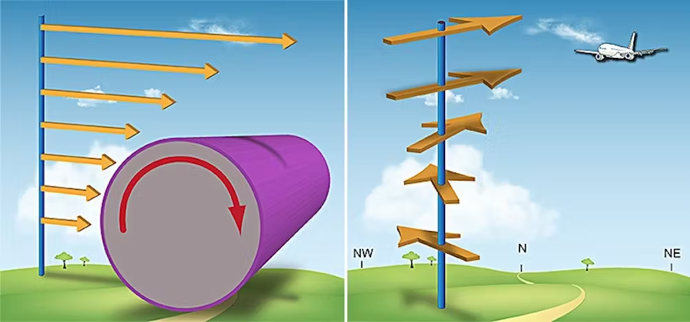
- About: Wind shear is a meteorological phenomenon that refers to a sudden change in wind speed and/or wind direction over a relatively small distance.
- Types: It is mainly of 2 types:
- Vertical Wind Shear: Occurs when wind speed and/or direction changes rapidly with increasing altitude.
- Common examples include low-level jet streams and wind shear associated with thunderstorms.
- Horizontal Wind Shear: Occurs when wind speed and/or direction changes rapidly over a horizontal distance.
- In this case, the wind might be blowing from the west at one spot, but then suddenly switch to blowing from the north just a bit further on.
- Common examples include frontal systems and sea breezes.
- Vertical Wind Shear: Occurs when wind speed and/or direction changes rapidly with increasing altitude.
- Major Causes:
- Temperature Inversion: During calm nights, warm air near the ground traps cooler air above, creating strong vertical wind shear, which could be a hazard for aircraft taking off and landing.
- Thunderstorms: Powerful updrafts and downdrafts within thunderstorms cause both horizontal and vertical wind shear, making flying near them dangerous.
- Frontal Systems: Boundaries between warm and cold air masses (fronts) create rapid changes in wind speed and direction, resulting in horizontal wind shear that can challenge aircraft navigation.
- Detection Methods:
- Low-Level Wind Shear Alert System (LLWAS): This network of ground-based towers uses anemometers (wind speed sensors) and wind direction sensors to measure wind speed and direction at multiple points around an airport.
- Doppler Radar: On the ground, these radars track wind speed and direction to spot wind shear zones.
- LIDAR: This uses light to detect wind shear, especially helpful for clear air turbulence.
What are the Effects of Wind Shear on Hurricanes?
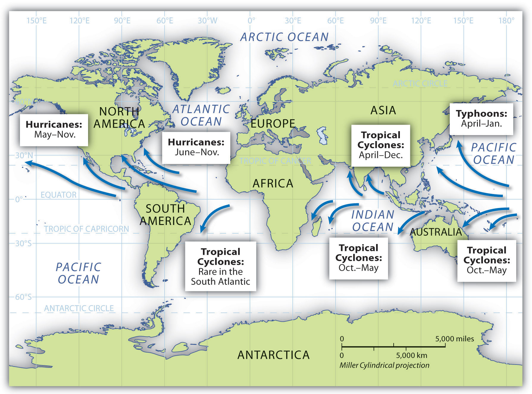
- About Hurricanes: Hurricanes or Tropical Cyclones are violent storms that originate over oceans in tropical areas and move over to the coastal areas bringing about large scale destruction caused by violent winds, very heavy rainfall and storm surges.
- Its formation and initial development depends upon the transfer of water vapor and heat from the warm ocean to the overlying air, primarily by evaporation from the sea surface.
- They are given many names in different regions of the world such as:
- Effects of Wind Shear on Hurricanes:
- Hurricanes thrive in environments with minimal vertical wind shear, as it allows for a symmetrical structure and efficient rotation.
- Strong vertical wind shear can disrupt the hurricane's vertical structure, offsetting the top of the storm from the bottom.
- This weakens the wind circulation, heat transport, and moisture supply, which are essential for fueling the hurricane.
- Excessive vertical wind shear can potentially tear a hurricane apart.
- Other Factors Affecting Hurricane Intensity:
- While vertical wind shear is a significant factor, it is not the only determinant of hurricane intensity.
- Other factors, such as sea surface temperatures, atmospheric moisture content, and pressure systems, also play crucial roles in hurricane development and strengthening.
- In some cases, exceptionally warm sea surface temperatures can overcome the effects of increased wind shear, as witnessed during the 2023 hurricane season.
- While vertical wind shear is a significant factor, it is not the only determinant of hurricane intensity.
What is the Influence of EL Nino and La Lina on Wind Shear?
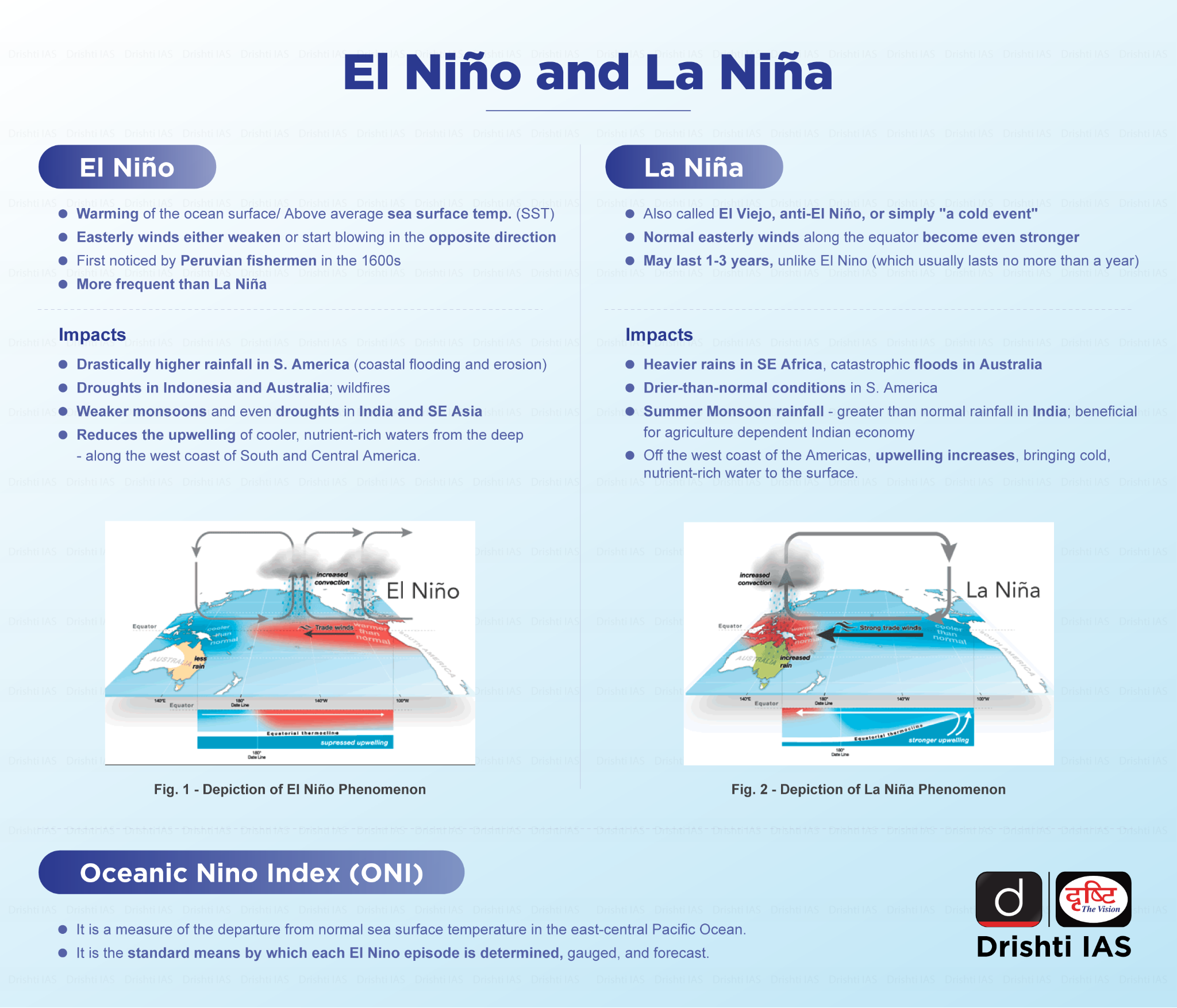
- El Nino's Influence on Wind Shear: During El Nino years, stronger-than-usual vertical wind shear is typically observed over the Atlantic Ocean during hurricane season.
- El Nino events are characterised by warmer sea surface temperatures in the eastern Pacific Ocean and cooler temperatures in the western Pacific.
- This pattern leads to stronger upper-level winds over the Atlantic, resulting in increased vertical wind shear.
- The increased wind shear during El Nino years can make it more challenging for hurricanes to develop and intensify in the Atlantic basin.
- La Nina's Influence on Wind Shear: La Nina conditions, which are the opposite of El Nino, tend to be more favorable for hurricane development in the Atlantic.
- During La Nina years, vertical wind shear is generally weaker over the Atlantic, allowing for more active hurricane seasons.
- The record-breaking 2020 Atlantic hurricane season occurred during a La Nina event.
Read More: Cyclone
UPSC Civil Services Examination, Previous Year Questions
Prelims
Q. In the South Atlantic and South-Eastern Pacific regions in tropical latitudes, cyclones do not originate. What is the reason? (2015)
(a) Sea surface temperatures are low
(b) Inter-Tropical Convergence Zone seldom occurs
(c) Coriolis force is too weak
(d) Absence of land in those regions
Ans: (b)
Q. In the context of which of the following do some scientists suggest the use of cirrus cloud thinning technique and the injection of sulfate aerosol into the stratosphere? (2019)
(a) Creating the artificial rains in some regions
(b) Reducing the frequency and intensity of tropical cyclones
(c) Reducing the adverse effects of solar wind on the Earth
(d) Reducing the global warming
Ans: (d)
Q. Consider the following statements: (2020)
- Jet streams occur in the Northern Hemisphere only.
- Only some cyclones develop an eye.
- The temperature inside the eye of a cyclone is nearly 10ºC lesser than that of the surroundings.
Which of the statements given above is/are correct?
(a) 1 only
(b) 2 and 3 only
(c) 2 only
(d) 1 and 3 only
Ans: (c)


