India’s Deep Drill Mission | 16 Jul 2024
For Prelims: India’ Deep Drill Mission, Fundamentals of Physical Geography, Geology, Volcano, Composition of Earth, Tectonic Plates
For Mains: Importance of Deep Drill Mission, Different layers in earth composition, Effects of tectonic plates movement, Important Geophysical Phenomena
Why in News?
Recently, the Ministry of Earth Science has started the task of scientific deep drilling of the earth’s crust to a depth of 6 km with the help of a specialised institute named Borehole Geophysics Research Laboratory (BGRL) in Karad, Maharashtra.
- It has already completed the drilling to a depth of 3 km.
Why is Koyna Uniquely Suited for India's Deep Drilling Mission?
- Triggered Seismicity: Unlike most earthquakes that occur at tectonic plate boundaries, Koyna witnessed a series of tremors following the construction of the Koyna Dam in 1962. This phenomenon, where human activity (filling the reservoir) triggered earthquakes, is called Reservoir-Induced Seismicity (RIS).
- Scientists aim to directly study the earth's composition and stresses at the source of these triggered earthquakes through deep drilling.
- Active Fault Zone: The Koyna-Warna region sits on a geological fault line, making it inherently prone to earthquakes.
- However, the triggered events here differ from those along plate boundaries.
- Isolated Activity: There are no other significant sources of seismic activity within a 50 km radius of the Koyna Dam. This isolation makes Koyna an ideal location for focused research.
What is Scientific Deep Drilling?
- About:
- Scientific deep drilling involves drilling deep into the Earth's crust to study its composition, structure, and processes.
- This research can provide insights into geological formations, natural resources, and Earth's history.
- Deep drilling projects often aim to advance our understanding of tectonics, earthquake mechanisms, and geothermal energy potential.
- Techniques and Methods:
- Rotary Drilling: This method uses a rotating drill bit to cut through rock formations. The drill bit is attached to a drill string, which is rotated by a rig. Drilling mud is circulated to cool the bit and carry rock cuttings to the surface.
- Percussion Drilling (Air Hammering): It uses high-pressure air to power a hammer that rapidly impacts a drill bit, efficiently breaking rock and flushing out cuttings. It's fast, cost-effective, and versatile for hard rock applications like mineral exploration, water wells, and geothermal energy, though it can be noisy and is best suited for shallower depths.
- The Koyna drilling technique combines mud rotary drilling and percussion drilling (air hammering).
- Hydraulic Fracturing (Fracking): Sometimes used to create fractures in rock formations, enhancing the flow of fluids for sampling or stimulating production in resource extraction.
- Geophysical Surveys: Employ seismic, magnetic, and gravitational methods to map subsurface structures and identify drilling targets before and during drilling operations.
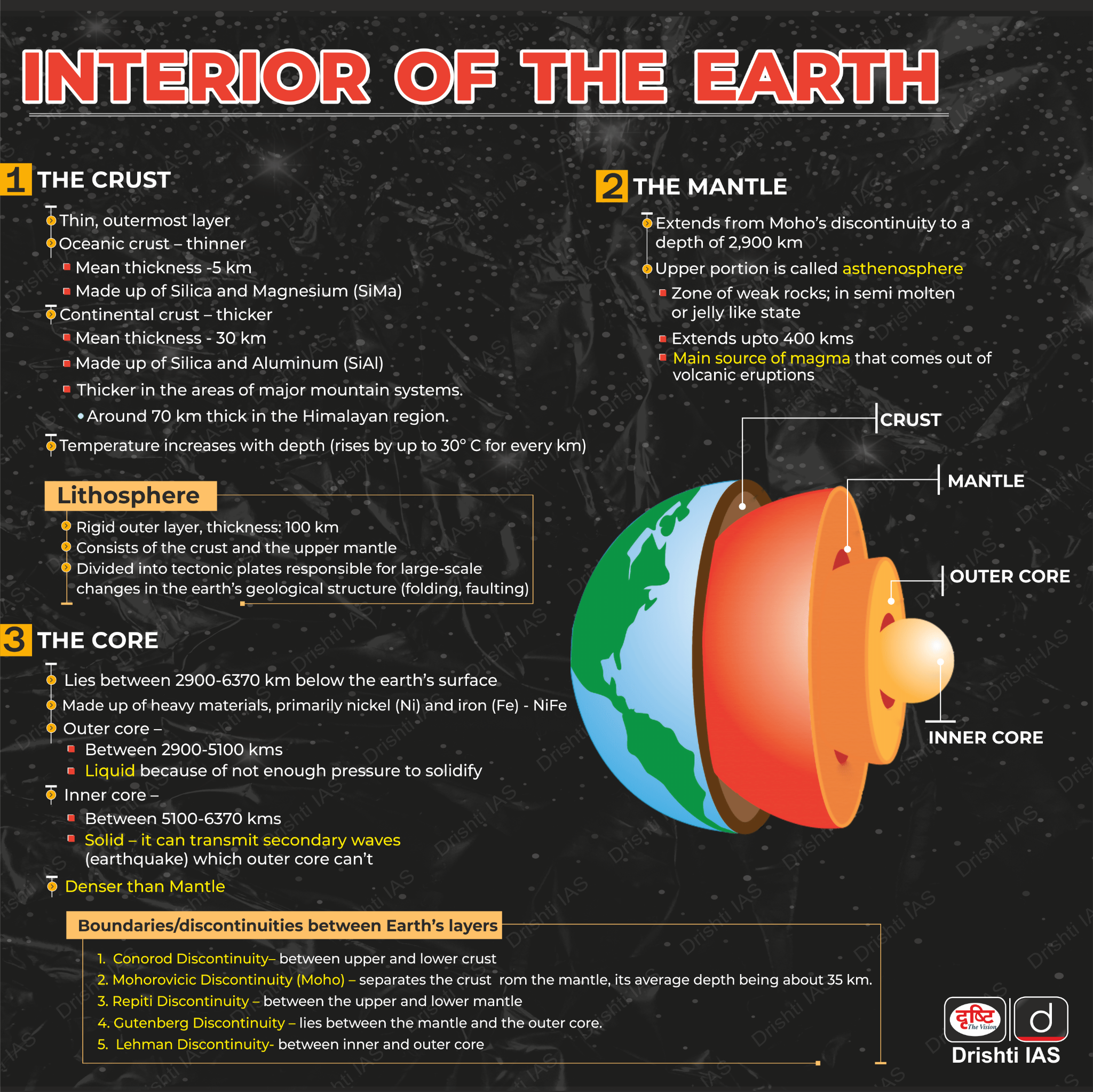
What are the Other Ways to Study the Interior of the Earth?
- The interior of the Earth is studied through direct methods like drilling and sampling rock from deep boreholes, and indirect methods such as seismic wave analysis, gravity measurements, and studying Earth's magnetic field.
- Seismic Waves: The study of seismic waves generated by earthquakes provides valuable information about the Earth's interior structure.
- Seismic waves travel through the Earth's interior and their behaviour, such as refraction and reflection, helps scientists infer the composition and properties of the different layers.
- Gravitational and Magnetic Field Measurements: Variations in the Earth's gravitational and magnetic fields can indicate changes in the density and composition of the interior. These measurements help identify the boundaries between the Earth's core, mantle, and crust.
- Heat Flow Measurements: The heat flowing out of the Earth's interior provides clues about the temperature and thermal properties of the different layers. This information is crucial for understanding the Earth's internal processes and dynamics.
- Meteorite Composition: The study of meteorites, which are believed to be remnants of the early solar system, can provide insights into the composition and formation of the Earth's interior.
- Seismic Waves: The study of seismic waves generated by earthquakes provides valuable information about the Earth's interior structure.
Other Deep Drilling Projects in the World
- Project Mohole of US: In the 1960s, the US attempted to drill the world's deepest hole to retrieve samples from the boundary between Earth's crust and mantle, known as the Moho Discontinuity.
- It was disbanded in 1966, but it demonstrated the potential for deep-ocean drilling to yield new geological insight about our planet.
- Kola Superdeep Borehole: It is the world's deepest man-made hole in Russia started in the 1970s, reaching a depth of 12,262 metres.
- It revealed unexpected findings such as the absence of the "Conrad discontinuity," the presence of liquid water at unexpected depths, and microscopic fossils dating back 2 billion years.
- It was discontinued in 1992, and the hole was sealed in 2005.
- China’s Deep Hole Project: China is drilling a 10,000-meter deep hole in the Xinjiang region to explore new frontiers above and below the Earth's surface.
- It aims to penetrate more than 10 continental strata and reach the cretaceous system, dating back 145 million years.
- Deep Sea Drilling Project (DSDP): It began in 1966, which involved drilling and coring in various oceans, leading to significant scientific discoveries, including the identification of salt domes and their potential for oil exploration. It was ended in 1972.
- The Integrated Ocean Drilling Project (IODP): It is an international initiative using ocean research platforms to study Earth's history and processes via seafloor samples.
- Its goals include understanding Earth's long-term processes, exploring the deep biosphere, studying climate history, and investigating Earth's crust and mantle.
- IODP employs research vessels from Japan, the US, and other partners for global expeditions, advancing planetary knowledge.
What are the Key Findings from the Deep Drilling Mission in Koyna?
- Region's Critical Stress: The Koyna region is highly stressed, making it susceptible to small stress perturbations that could trigger frequent, small-magnitude earthquakes.
- Water Presence to 3 km: Water found down to 3 km is meteoric or rain-fed, indicating deep percolation and circulation.
- Insights into Reservoir-triggered Earthquakes: The mission revealed 1.2 km of 65 million-year-old Deccan trap lava flows overlying 2,500-2,700 million-year-old granitic basement rocks.
- Rock Information: Core samples from 3 km depth provided new information on the physical and mechanical properties of rocks, the chemical and isotopic composition of formation fluids and gases, temperature and stress regimes, and fracture orientations.
- Data Validation: High-resolution images of the borehole wall using acoustic and micro-resistivity techniques allow global scientists to validate data from other cores.
- Hydraulic Fracturing and Fault Detection: The team conducted hydraulic fracturing experiments to measure the in-situ stress regime of the rocks. By integrating various datasets and advanced analysis, they detected and studied buried fault zones.
What is the Significance of Deep Drilling Mission?
- Enhanced Earthquake Understanding and Geohazard Management: It can be achieved by installing sensors in deep boreholes to monitor fault lines, leading to better predictive models and risk mitigation.
- Additionally, deep drilling provides precise data on the Earth's crust, essential for managing geohazards and exploring geo-resources like minerals and hydrocarbons.
- Verification of Geological Models: Drilling allows for direct observation and sampling, confirming or refuting geological models and enhancing our understanding of tectonic processes and crustal dynamics.
- Technological Innovation and Self-Reliance: Investing in deep drilling drives advancements in seismology, drilling techniques, sensor development, and data analysis, promoting technological self-reliance in India.
- Global Scientific Contribution: Findings from deep drilling projects in India contribute to global geoscience knowledge, fostering international collaboration and enhancing overall understanding of Earth's systems.
What are the Challenges with Deep Drilling Missions?
- Rig Capacity: The drilling rig's hook load capacity becomes a critical limitation at greater depths, requiring a significantly more powerful rig for 6 km compared to the 100-tonne rig used for the 3 km pilot.
- Drilling Complexity: Drilling through fractured and seismically active rock formations becomes increasingly complex at greater depths, with higher risks of equipment getting stuck and complications in troubleshooting due to limited access.
- Core Handling: Extracting and lifting the long, heavy rock cores from over 3 km depth poses significant technical challenges.
- Borehole Stability: Deeper boreholes are more prone to encountering fault lines and fracture zones, which can compromise borehole stability and require specialised equipment for steering the drill.
- Human Resources: The extended duration of deep drilling operations, lasting 6-8 months for 3 km and 12-14 months for 6 km, places a significant burden on the highly skilled technical personnel required to work on-site 24/7 in harsh conditions.
Conclusion
The 3 km pilot drilling data will guide future 6 km plans, including equipment and sensor design for temperatures of 110-130°C. Koyna's findings enable diverse research, from fault zones to deep subsurface microbes, with industrial potential. International interest includes projects on carbon capture in deep Deccan traps. This effort strengthens India's scientific drilling capacity and broadens interdisciplinary knowledge.
|
Drishti Mains Question: What is Scientific Deep Drilling? What are its significance and challenges? |
UPSC Civil Services Examination Previous Year Question (PYQ)
Prelims:
Q. Consider the following: (2013)
- Electromagnetic radiation
- Geothermal energy
- Gravitational force
- Plate movements
- Rotation of the earth
- Revolution of the earth
Which of the above are responsible for bringing dynamic changes on the surface of the earth?
(a) 1, 2, 3 and 4 only
(b) 1, 3, 5 and 6 only
(c) 2, 4, 5 and 6 only
(d) 1, 2, 3, 4, 5 and 6
Ans: (d)
Mains:
Q. The frequency of earthquakes appears to have increased in the Indian subcontinent. However, India’s preparedness for mitigating their impact has significant gaps. Discuss various aspects. (2015)
Q. Discuss about the vulnerability of India to earthquake related hazards. Give examples including the salient features of major disasters caused by earthquakes in different parts of India during the last three decades. (2021)