Increase in Coastal Erosion | 05 Aug 2024
For Prelims: Coastal Erosion, Climate Change, Kattupalli Port, Sundarbans, Andaman and Nicobar Islands, Salinization, Groynes, Wetlands, National Centre for Coastal Research (NCCR), Coastal Regulation Zone (CRZ) Notification 2019, No Development Zones (NDZ), Coastal Zone Management Plans (CZMP), National Green Tribunal (NGT), National Strategy for Coastal Protection, Coastal Management Information System (CMIS)
For Mains: Causes and Impacts of Coastal Erosion in Littoral States and UTs.
Why in News?
A recent study revealed that coastal erosion is threatening the livelihood of fishers and other inhabitants in coastal Tamil Nadu.
- Nearly 43% of its coast faces erosion with a loss of more than 4,450 acres of land.
- Area under erosion is increasing by 3 metres per year on the east coast and 2.5 metres per year on the west coast.
- Development projects meant to boost economic growth and prevent sea erosion are making things worse by changing the shoreline.
What are the Key Findings of the Study Regarding Tamil Nadu Coast?
- In Tamil Nadu, for most of the year (about eight months), the wind and sea currents move from south to north, carrying sand with them. During the northeast monsoon (about four months), they flow in the opposite direction.
- When structures like ports, breakwaters or groynes are built extending into the sea, they block the natural movement of sand.
- This causes sand to pile up on one side and leads to erosion on the other side, where sand is lost.
- This imbalance speeds up coastal erosion, causing waves to move further inland and increasing the risk to coastal areas.
What is Coastal Erosion?
- About: Coastal erosion occurs when the sea wears away the land, often caused by strong waves breaking down the coast.
- It is the process by which local sea level rise, strong wave action, and coastal flooding wear down or carry away rocks, soils, and/or sands along the coast.
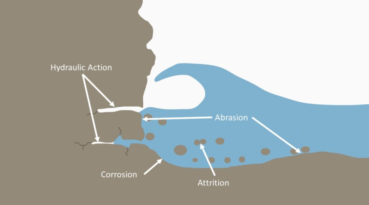
- Process: There are four main processes of coastal erosion. These are corrasion, abrasion, hydraulic action and attrition.
- Corrasion: It happens when strong waves throw beach material like pebbles at the base of a cliff, gradually breaking it down and creating a wave-cut notch (small, curved indent at the base of a cliff).
- Abrasion: It happens when waves, carrying sand and larger fragments, wear away the base of a cliff or headland. It's like a sandpaper effect and is especially common during powerful storms.
- Hydraulic Action: It occurs when waves hit a cliff, compressing air in cracks and joints. When the wave pulls back, the trapped air rushes out explosively, causing chunks of the cliff to break off. Weathering weakens the cliff further, making this process more effective.
- Attrition: It occurs when waves cause rocks and pebbles to bump into each other and break up.
- Causes:
- Waves: Powerful waves can erode coastlines through abrasion, corrasion, and hydraulic action. E.g. the cliffs of Dover in England are being eroded by the constant action of the English Channel's waves.
- Tides: High and low tides can affect the amount of erosion, particularly in areas with significant tidal ranges. E.g., the Bay of Fundy in Canada experiences extreme tides that can erode coastlines significantly.
- Wind and Sea Currents: It can cause gradual and long-term erosion. E.g., On the Tamil Nadu coast, for most of the year (eight months), wind and sea currents move from south to north, carrying sand along the coast. During the northeast monsoon (four months), this direction reverses.
- Hard Structures: Ports, breakwaters, and groynes interfere with the natural movement of sand, causing erosion on the down-current side and sand accumulation on the up-current side.
- Groynes are low-lying wood or concrete structures designed to trap sediment and dissipate wave energy.
- Development Projects: Infrastructure projects aimed at boosting economic growth are exacerbating erosion by altering the shoreline. E.g., Land reclamation in places like Mumbai causes erosion in nearby coastal regions.
- Port Expansion: When ports and harbours are expanded, structures like breakwaters and jetties block the natural movement of sand and sediment along the coast. This can lead to sediment accumulation on one side of the structure and increased erosion on the other side. E.g., Ennore Port and the Adani Kattupalli Port in Tamil Nadu.
Coastline of India
- India has a coastline of 7516.6 Km [6100 km of mainland+1197 km of islands] touching 13 States and Union Territories (UTs).
- Gujarat (1214.7 km) has the longest Coastline among states followed by Andhra Pradesh (973.7 km) and Tamil Nadu (906.9 km).
- Andaman & Nicobar Islands (1962 km) have the longest Coastline among UTs.
- Coromandel coast (Tamil Nadu) is a coast of emergence while Konkan coast (Maharashtra and Goa Coast) is a coast of submergence.
What are the Impacts of Coastal Erosion?
- Loss of Land: Erosion can lead to the loss of valuable coastal land, affecting property and infrastructure. E.g. the loss of land along the Marina Beach area in Chennai severely affected property and public spaces.
- Impact on Coastal Ecosystems: Erosion can destroy habitats such as mangroves, salt marshes and sand dunes, which are crucial for various species. E.g., In the Sundarbans region of West Bengal, erosion has led to the loss of mangrove forests.
- Flooding Risk: Erosion can reduce the natural barriers that protect coastal areas from flooding. E.g., In coastal regions of Kerala, erosion has increased the risk of flooding, affecting low-lying areas and exacerbating the impacts of heavy rains and storms.
- Displacement of Communities: Erosion can force communities to relocate, leading to social and economic disruption. E.g., coastal erosion in the Andaman and Nicobar Islands has led to the displacement of local communities, particularly on smaller islands where land loss is more pronounced.
- Salt Water Intrusion: Coastal erosion can lead to the salinisation of agricultural land, reducing crop yields.
- Eg., In Andhra Pradesh, saltwater intrusion negatively affected crop yields and reduced the productivity of farmland.
- Impact on Marine and Coastal Biodiversity: It can alter ecosystems and food chains. E.g., It hampered the health of marine ecosystems in the Lakshadweep Islands.
How to Prevent Coastal Erosion?
- Vegetation: Strategic planting of seagrass and other coastal plants helps prevent erosion. The roots of these plants help anchor the sand and ensure that it is not washed off in erosion.
- Beach Nourishment: Nature-based or "green infrastructure" protection measures enhance the natural ability of shorelines to absorb and dissipate storm energy without interfering with natural coastal processes.
- E.g., planting mangroves to serve as a buffer against erosion.
- Coastal Restoration: It is aimed at restoring habitats such as wetlands to benefit marine and coastal species by providing important nursery grounds. It has environmental benefits like carbon sequestration and restoration of open spaces.
- Regulatory Measures: Zoning laws, building codes, and maintaining minimum distance from the shoreline for new buildings or infrastructure facilities to regulate coastal development.
What Initiatives has the Government Taken to Tackle Coastal Erosion?
- Shoreline Mapping System: The National Centre for Coastal Research (NCCR) has observed that 33.6% of the Indian coastline was vulnerable to erosion, 26.9% was under accretion (growing) and 39.6% was in a stable state.
- Hazard Line: The Ministry of Environment, Forest & Climate Change (MoEFCC) has defined the hazard line to indicate shoreline changes and sea level rise.
- It is used for disaster management, adaptive planning, and mitigation measures in Coastal States/UTs.
- Coastal Regulation Zone (CRZ) Notification 2019: It permits erosion control measures and establishes No Development Zones (NDZ) to protect the coastline from encroachment and erosion.
- Coastal Zone Management Plans (CZMP): Following a National Green Tribunal (NGT) order, States/UTs have been asked to finalise CZMPs, including mapping of erosion-prone areas and preparing Shoreline Management Plans.
- National Strategy for Coastal Protection: MoEFCC has developed a national strategy and guidelines for coastal protection for all Coastal States and UTs.
- Flood Management Scheme: Anti-sea erosion schemes are planned and executed by State Governments with Union Government assistance in technical, advisory, catalytic, and promotional capacities.
- Coastal Management Information System (CMIS): It collects nearshore coastal data for planning, designing, and maintaining coastal protection structures. An experimental CMIS was set up at three sites each in Kerala, Tamil Nadu, and Puducherry.
Conclusion
Coastal erosion threatens India's coastlines, harming the environment and local communities. Natural and human factors worsen shoreline changes, leading to habitat loss and affecting fishermen. Improved shoreline mapping and government measures, like hazard lines and CRZ Notification 2019, aim to manage and protect coastlines. Ongoing efforts, such as CMIS, seek to enhance these strategies.
|
Drishti Mains Question: Q. Discuss how climate change and rising sea levels are posing threats to India’s coastal ecosystem. |
UPSC Civil Services Examination, Previous Year Questions (PYQs)
Mains
Q. Coastal sand mining, whether legal or illegal, poses one of the biggest threats to our environment. Analyse the impact of sand mining along the Indian coasts, citing specific examples. (2019)
Q. Discuss the causes of the depletion of mangroves and explain their importance in maintaining coastal ecology. (2019)