Geography
Godavari and Cauvery River Interlinking Project
- 11 Feb 2020
- 4 min read
Why in News
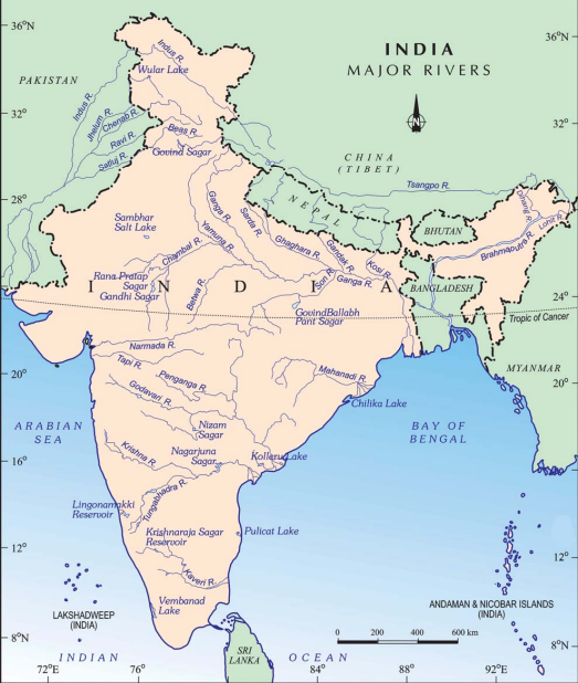
The National Water Development Agency (NWDA) has circulated a draft Detailed Project Report (DPR) on Godavari-Cauvery link project to the concerned states to elicit their views.
- The project envisages the diversion of 247 thousand million cubic feet (tmcft) of unutilised water in the Indravati sub-basin of the Godavari basin to meet the requirements between the Godavari and the Cauvery rivers.
- Water will be diverted from Godavari river to Nagarjuna Sagar dam(through lifting) and further south to meet the demands of Krishna, Pennar and Cauvery basins.
- The Godavari - Cauvery link comprises three components namely,
- the Godavari (Inchampalli/Janampet) - Krishna (Nagarjunasagar),
- the Krishna (Nagarjunasagar) – Pennar (Somasila) and
- the Pennar (Somasila)–Cauvery.
- The project will provide irrigation facilities to 3.45 to 5.04 lakh hectares in Prakasam, Nellore, Krishna, Guntur, and Chittoor districts of Andhra Pradesh.
National Water Development Agency
- NWDA is a registered society under the Ministry of Jal Shakti.
- It was set up in the year 1982 to carry out detailed studies, surveys and investigations in respect of the Peninsular Component of National Perspective for Water Resources Development, which envisages inter-basin water transfer.
Godavari River
- Source: Godavari river rises from Trimbakeshwar near Nasik in Maharashtra and flows for a length of about 1465 km before outfalling into the Bay of Bengal.
- Drainage Basin: The Godavari basin extends over states of Maharashtra, Andhra Pradesh, Chhattisgarh and Odisha in addition to smaller parts in Madhya Pradesh, Karnataka and Union territory of Puducherry.
- Tributaries: Pravara, Purna, Manjra, Penganga, Wardha, Wainganga, Pranhita (combined flow of Wainganga, Penganga, Wardha), Indravati, Maner and the Sabri.
Krishna River
- Source: It originates near Mahabaleshwar (Satara) in Maharashtra.
- Drainage Basin: It runs from four states namely, Maharashtra, Karnataka,Telangana and Andhra Pradesh before emptying into the Bay of Bengal.
- Tributaries: Tungabhadra, Mallaprabha, Koyna, Bhima, Ghataprabha, Yerla, Warna, Dindi, Musi and Dudhganga.
- Nagarjunasagar dam is on the river Krishna.
Pennar River
- Source: It rises in Nandi Hills in Chikballapur District of Karnataka and runs north and east before emptying into the Bay of Bengal.
- Drainage Basin: It is 597 kilometres long, with a drainage basin covering 55,213 km2 in Karnataka and Andhra Pradesh.
- Tributaries: Jayamangali, Kunderu, Sagileru,Chitravathi, Papagni and Cheyyeru.
Cauvery River
- Source: The river rises on Brahmagiri Hill of the Western Ghats in southwestern Karnataka.
- Drainage Basin: It flows in a southeasterly direction through the states of Karnataka and Tamil Nadu, and descends the Eastern Ghats in a series of great falls. Before emptying into the Bay of Bengal south of Cuddalore, Tamil Nadu, the river breaks into a large number of distributaries forming a wide delta called the “garden of southern India.”
- Tributaries: Arkavathi, Hemavathi, Lakshmana Theertha, Shimsa, Kabini and Harangi.


