Double-Dip La Niña
Why in News
Recently, the National Oceanic and Atmospheric Administration (NOAA, an American scientific agency) has declared that La Niña has re-developed. Consecutive La Niña is called Double-Dip.
Key Points
- About:
- La Nina is one part of the El Nino Southern Oscillation (ENSO) cycle, which is characterized by opposing warm and cool phases of oceanic and atmospheric conditions in the tropical Pacific Ocean.
- Consecutive La Ninas following a transition through ENSO neutral conditions are not uncommon and can be referred to as a “Double-Dip.”
- In 2020, La Nina developed during the month of August and then dissipated in April 2021 as ENSO-neutral conditions returned.
- For the upcoming winter season, which extends from December 2021 through February 2022, there is an 87% chance of La Nina.
- Previous La Ninas occurred during the winter of 2020-2021 and 2017-2018, and an El Nino developed in 2018-2019. When neither climate pattern is present, ENSO is neutral and does not influence global climate patterns.
- ENSO:
- It is a periodic fluctuation in sea surface temperature (El Niño) and the air pressure of the overlying atmosphere (Southern Oscillation) across the equatorial Pacific Ocean.
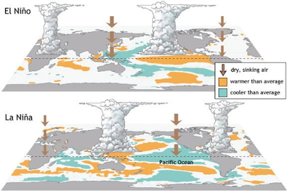
- El Nino and La Nina are complex weather patterns resulting from variations in ocean temperatures in the Equatorial Pacific Region. They are opposite phases of what is known as the ENSO cycle.
- El Nino and La Nina episodes typically last nine to 12 months, but some prolonged events may last for years.
| El Nino and La Nina |
 |
| Basis of Comparison |
El Nino |
La Nina |
| About |
- El Niño means Little Boy, or Christ Child in Spanish. During an El Niño event, ocean water from off the coast of South America (near Ecuador and Peru) to the central tropical Pacific warm above average.
|
- La Niña means Little Girl in Spanish. During a La Niña event, ocean water from off the coast of South America to the central tropical Pacific cools to below average temperatures.
|
| Occurrence |
- The warming takes place as trade winds (the permanent east-to-west prevailing winds that flow around the equator) weaken or even reverse, blowing warm water from the western Pacific toward the east. As a result, sea temperatures in the far western Pacific can cool below average.
|
- This cooling occurs because of stronger than normal easterly trade winds, which churns cooler, deeper sea water up to the ocean’s surface. Sea temperatures can warm above average in the far western Pacific when this happens.
|
| Impact |
- On Walker Circulation: The unusually warm water in the eastern Pacific then influences the Walker Circulation (an atmospheric system of air flow in the equatorial Pacific Ocean), acting as a focal point for cloud, rainfall, and thunderstorms. It is this change in the Walker Circulation that impacts weather patterns around the world.
- On the Pacific Jet Stream: The warmer waters cause the Pacific jet stream to move south of its neutral position. With this shift, areas in the northern US and Canada are dryer and warmer than usual. But in the US Gulf Coast and Southeast, these periods are wetter than usual and have increased flooding.
- On Marine Life: El Niño also has a strong effect on marine life off the Pacific coast. During El Niño, upwelling weakens or stops altogether. Upwelling is movement of colder, nutrient-rich water from the depths to the surface.
- Without the nutrients from the deep, there are fewer phytoplankton off the coast. This affects fish that eat phytoplankton and, in turn, affects everything that eats fish.
- On the Indian Ocean: El Nino is associated with lower than normal monsoon rainfall in India.
|
- On Walker Circulation: The unusually cool water in the eastern Pacific influences the Walker Circulation and suppresses cloud, rain, and thunderstorms. This change impacts weather patterns around the world, but in a different way than El Niño does.
- On the Pacific Jet Stream: These cold waters in the Pacific push the jet stream northward. This tends to lead to drought in the southern US and heavy rains and flooding in the Pacific Northwest and Canada. It can also lead to a more severe hurricane season.
- On Marine Life: Off the west coast of the Americas, upwelling increases, bringing cold, nutrient-rich water to the surface.
- On the Indian Ocean: There are increased temperatures in Western Pacific, Indian Ocean and off the Somalian coast. It also leads to heavy floods in Australia and a comparatively better monsoon rains in India.
|
Source: DTE


