International Relations
China's 'Xiaokang' Border Defence Villages along the LAC
- 24 Feb 2024
- 8 min read
For Prelims: Line of Actual Control (LAC), Xiaokang Border Defence Villages, Tibet Autonomous Region, Line of Control, Vibrant Villages program
For Mains: India China Border Dispute, India and its Neighbourhood, Effect of Policies of Countries on India's Interests
Why in News?
In recent developments along the Line of Actual Control (LAC) between India and China, Chinese nationals have begun occupying previously vacant "Xiaokang" border defence villages.
- These villages, constructed by China in 2019, have raised concerns for the Indian Army, particularly regarding their occupants' nature and strategic implications.
What are the "Xiaokang" Border Defence Villages?
- Model Villages:
- The Xiaokang or “well-off villages” border defence villages are a part of China's strategic infrastructure development initiative along its borders, particularly along the LAC with India.
- Notable areas of occupation include villages across from Lohit Valley and the Tawang sector of Arunachal Pradesh.
- They are built in regions where territorial claims are contested or where there is a perceived need to reinforce sovereignty.
- The Xiaokang or “well-off villages” border defence villages are a part of China's strategic infrastructure development initiative along its borders, particularly along the LAC with India.
- Dual-use Infrastructure:
- These villages are designed to serve multiple purposes, including civilian settlement and military presence, hence characterized as "dual-use infrastructure."
- They are built in regions where territorial claims are contested or where there is a perceived need to reinforce sovereignty.
- Associated Concerns for India:
- Territorial Claims: China's construction of 628 such villages along India's borders with the Tibet Autonomous Region signifies a concerted effort to assert territorial claims along the LAC.This raises concerns for Indian military strategists, highlighting the need for vigilance along the border.
- Military Implications: The villages' potential for dual-use raises concerns about increased militarisation along the already tense LAC.
- Uncertain Intentions: The lack of transparency regarding the specific purpose and scale of the civilian population in these villages creates suspicion and hinders trust-building efforts.
What are India's Initiatives along the LAC?
In response to China's infrastructure development, India has intensified efforts to enhance its border infrastructure since 2019.
- Vibrant Villages Program:
- The Vibrant Villages program aims to modernise 663 border villages, with 17 selected for development along the China-India border in regions like Ladakh, Himachal Pradesh, Uttarakhand, Sikkim, and Arunachal Pradesh.
- Border Roads Organization (BRO):
- The BRO has completed 90 infrastructure projects along the India–China border, worth Rs 2,941 crore.
- As of September 2023, 36 of these projects are in Arunachal Pradesh, 26 in Ladakh, and 11 in Jammu and Kashmir.
- BRO is involved in major highways, including the Trans-Arunachal Highway, Frontier Highway, and East-West Industrial Corridor Highway, which are under construction to improve connectivity, particularly in the eastern part of Arunachal Pradesh and the Tawang region.
- The BRO has completed 90 infrastructure projects along the India–China border, worth Rs 2,941 crore.
- Border Area Development Programme (BADP):
- The BADP is a centrally sponsored scheme that aims to meet the special developmental needs of the people living in remote and inaccessible areas situated near the international border.
- The funds can be used for projects relating to Infrastructure, Livelihood, Education, Health, Agriculture, Allied sectors.
- Railways:
- Indian Railways is constructing strategic rail lines in the Northeast region to facilitate the swift mobilization of the Indian army.
What is the Line of Actual Control (LAC)?
- About:
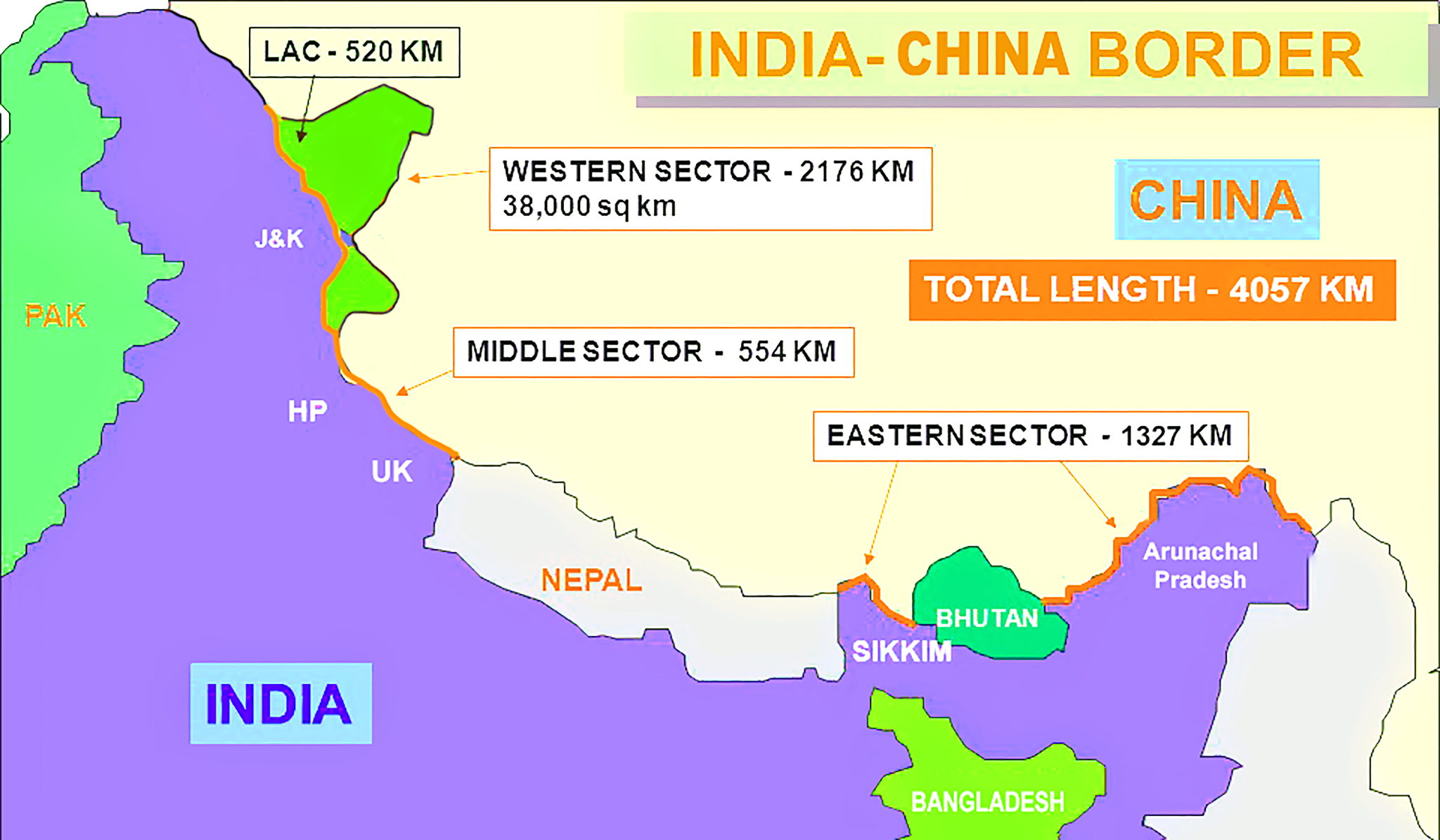
- The LAC serves as the boundary separating Indian-controlled territory from Chinese-controlled territory.
- India asserts the length of the LAC to be 3,488 km, whereas China contends it to be approximately 2,000 km.
- This demarcation is categorized into three sectors:
- Eastern sector encompassing Arunachal Pradesh and Sikkim.
- Middle sector spanning Uttarakhand and Himachal Pradesh.
- Western sector located in Ladakh.
- The LAC serves as the boundary separating Indian-controlled territory from Chinese-controlled territory.
- Disagreements Surrounding the LAC:
- The primary dispute regarding the LAC arises from its alignment in different sectors. The LAC in the eastern sector follows the 1914 McMahon Line with minor disputes about ground positions.
- Major disagreements exist in the Western sector, originating from letters written by Chinese Prime Minister Zhou Enlai to PM Jawaharlal Nehru in 1959.
- The LAC was described only in general terms on maps not to scale by the Chinese.
- The Chinese claimed to have withdrawn to 20 km behind the LAC in November 1959 after the 1962 War.
- During the Doklam crisis in 2017, the Chinese Foreign Ministry spokesperson urged India to abide by the "1959 LAC".
- Despite subsequent clarifications, ambiguity persisted, leading to contrasting interpretations by both nations.
- India's Response to China's LAC Designation:
- India initially rejected the concept of the LAC in 1959 and 1962, citing concerns over its vague definition and potential exploitation by China to alter ground realities through military force.
- India's shift in the LAC approach started in the mid-1980s due to increased border encounters, prompting a review of patrolling boundaries.
- India formally accepted the concept of the LAC in 1993 and the two sides signed the Agreement to Maintain Peace and Tranquility at the LAC.
- India and China have only exchanged maps for the middle sector of the LAC. Maps were "shared" for the Western sector but never formally exchanged, and the process of clarifying the LAC has effectively stalled since 2002.
- The most serious recent episodes of conflict were in Galwan Valley in Ladakh in 2020 and in Tawang in Arunachal Pradesh in 2022.
- Observers on both sides of the LAC agree that the number of serious military confrontations has increased since 2013.
- India initially rejected the concept of the LAC in 1959 and 1962, citing concerns over its vague definition and potential exploitation by China to alter ground realities through military force.
- LAC vs Line of Control with Pakistan:
- The Line of Control (LoC) was established in 1972 after the Kashmir War, based on the ceasefire line negotiated by the UN in 1948. It has international legal validity and is delineated on a map signed by both countries.
- On the other hand, the LAC is not agreed upon by both countries and is not delineated on a map or demarcated on the ground.
- The Line of Control (LoC) was established in 1972 after the Kashmir War, based on the ceasefire line negotiated by the UN in 1948. It has international legal validity and is delineated on a map signed by both countries.
UPSC Civil Services Examination, Previous Year Question (PYQ)
Prelims:
Q. Siachen Glacier is situated to the (2020)
(a) East of Aksai Chin
(b) East of Leh
(c) North of Gilgit
(d) North of Nubra Valley
Mains:
Q. Border management is a complex task due to difficult terrain and hostile relations with some countries. Elucidate the challenges and strategies for effective border management. (2016).


