Assam Floods | 09 Jul 2024
For Prelims: Flood, Landslide, Brahmaputra River System, Kaziranga National Park, Topography of India
For Mains: Causes of floods, Impact on life and economy, Measures to tackle, Disaster Management Bodies
Why in News?
Recently, floods in Assam have resulted in over 50 deaths, displacing 360,000 people.
- More than 40,000 hectares of crops and 130 wild animals have been affected by flooding.
What is Flood?
- About:
-
Floods are the most frequent type of natural disaster and occur when an overflow of water submerges land that is usually dry.
- Between 1998-2017, 2 Billion people have been affected worldwide due to floods.
-
- Causes:
- These are often caused by heavy rainfall, rapid snowmelt or a storm surge from a tropical cyclone or tsunami in coastal areas.
- Types of Floods:
- Flash Floods: These are caused by rapid and excessive rainfall that raises water heights quickly, and rivers, streams, channels or roads may be overtaken.
- River Floods: These are caused when consistent rain or snow melt forces a river to exceed capacity.
- Coastal Floods: These are caused by storm surges associated with tropical cyclones and tsunami.
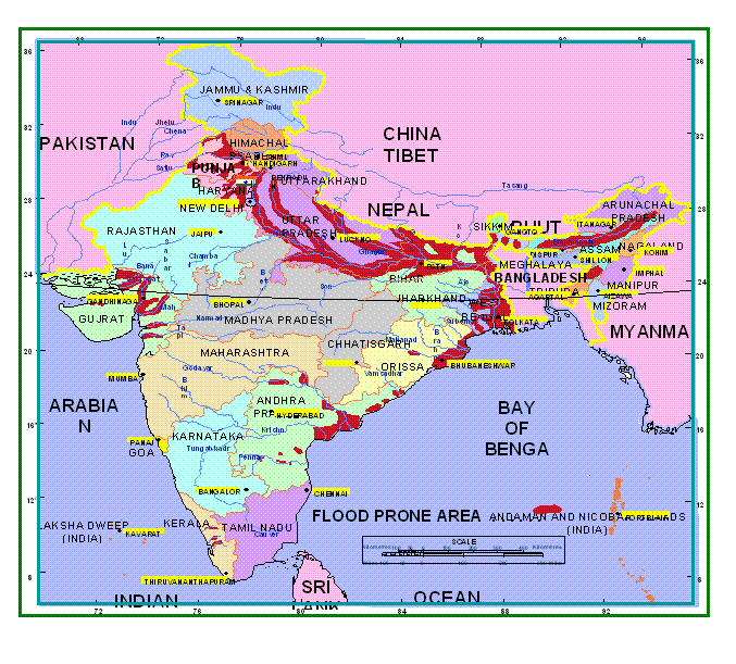
- State of Flood in India:
- India has a total geographical area of 329 million hectares, out of which more than 40 million hectares are flood-prone.
- Flood-related damages have shown an increasing trend, with the average annual flood damage between 1996-2005 being Rs. 4745 crore, compared to Rs. 1805 crore in the previous 53 years.
- Floods Prone Area in India:
NDMA Guidelines for Floods
- Preparing for Floods:
- Avoid building in flood-prone areas unless you elevate and reinforce your home.
- Elevate furnace, water heater, and electrical panel if susceptible to flooding.
- Install check valves in sewer traps to prevent flood water backup.
- Contact officials about flood barriers being constructed in your area.
- Seal basement walls with waterproofing compounds.
-
When a Flood is Likely:
- Listen to radio/TV for information.
- Be aware of flash flooding - move to higher ground immediately if risk.
- Be aware of areas known to flood suddenly.
- If Evacuating:
- Secure your home - bring in outdoor furniture, move items upstairs.
- Turn off utilities if instructed.
- Do not walk or drive through moving floodwater.
What are the Causes of Regular Floods in Assam?
- Large Number of Rivers:
- Assam has more than 120 rivers, several of which originate from the hills and mountains of extreme rainfall hotspots in Arunachal Pradesh and Meghalaya as well as in China and Bhutan.
- The Brahmaputra river, flowing through Assam, accumulates significant sediment as it reaches the lower elevation of Assam, slowing down and depositing sediment and debris.
- In summer, sedimentation intensifies due to soil erosion from glacier melting.
- The Monsoon:
- The monsoon is intense in the Northeast. According to the State Disaster Management Authority, annual rainfall averages around 2900 mm with maximum precipitation in June and July.
- As per data from Assam government, 85% of the annual rainfall in the Brahmaputra basin takes place during the monsoon months.
- It also gets a good amount of rainfall in April and May due to thunderstorm (Kalbaisakhi) activities which account for flooding during heavy rain in June.
- The monsoon is intense in the Northeast. According to the State Disaster Management Authority, annual rainfall averages around 2900 mm with maximum precipitation in June and July.
- Climate Change:
- The melting of glaciers and snow caps in the Tibetan Plateau due to global warming and climate change is causing increased water flow in the Brahmaputra River, impacting downstream regions like Assam with more frequent flooding.
- Human Intervention:
- Construction of Embankments: Construction of embankments first started in Assam in the 1960s to control floods. However, six decades later, most of these embankments have either outlived their utility or are in bad condition.
- Population Boom: Population boom has put more pressure on the State’s ecology.
- The population density of Brahmaputra valley has increased from 9-29 people per sq. km. in 1940-41 to 398 per sq. km in the plain areas of Assam as per the 2011 census, according to a report by the Brahmaputra Board. This has led to human settlements in river basin areas becoming more vulnerable to floods.
- Jhum cultivation: It is also known as shifting cultivation, involves slash-and-burn practices that strip the soil's protective layer, leading to accelerated erosion and reduced water absorption capacity. Soil and plant material runoff contribute to sedimentation in river basins.
What are the Implications of Floods in Assam?
- Loss of Wildlife: The floods have resulted in the death of over 130 wild animals, including at least 6 rare one-horned rhinos in Kaziranga National Park, Assam. Other animals that have perished include 117 hog deer, 2 sambar deer, a rhesus macaque, and an otter.
- Kaziranga is home to the world's largest population of one-horned rhinos.
- Damage to Infrastructure: The floods have caused extensive damage to roads and other infrastructure, hampering rescue and relief efforts.
- Displacement of People: The floods in Assam have displaced over 2 million people, with many seeking shelter in relief camps. This has put additional strain on the resources and management.
What are the Steps Taken to Manage Floods in India?
- National Flood Management Programme (NFMP): It was launched in 1954 to provide a flexible framework for states to choose site-specific interventions, considering geographical realities and resource constraints. It emphasises both structural (dams, embankments) and non-structural (floodplain zoning) measures.
- Rashtriya Barh Ayog (1976): This established an integrated approach for flood control, prioritizing scientific analysis and national planning.
- National Water Policy (2012): This policy advocates strategic reservoir operation to create flood cushions and minimise sedimentation during floods. Floodplain zoning is emphasized for regulated development in flood-prone areas.
- National Hydrology Project (2016): This project strengthens flood forecasting through real-time hydro-meteorological data accessible at all levels (state, district, village).
- Flood Management and Border Areas Programme (FMBAP): This program focuses on catchment area treatment to reduce sediment load in rivers, thereby enhancing their carrying capacity and minimizing overflow.
- Flood Plain Zoning: This strategy aims to demarcate flood-prone areas and regulate land use to prevent encroachment and minimise damage.
- Flood Proofing: Elevating vulnerable settlements and crucial infrastructure above flood levels can significantly reduce losses.
National Disaster Response Force (NDRF)
- It is an Indian specialised force constituted under the Disaster Management Act, 2005.
- The responsibility of managing disasters in India is that of the state governments. The ‘Nodal Ministry’ in the central government for management of natural disasters is the Ministry of Home Affairs (MHA).
- It refers to trained professional units that are called upon for specialised response to disasters.
Way Forward
- Early Warning Systems: The need for new early warning and response systems to adapt to floods is evident from past experiences. It is essential to provide credible information for better preparedness and alerting residents.
- A parliamentary panel in 2021 suggested modernising flood warning systems by installing advanced weather stations and sirens.
- Improved Infrastructure: Investing in well-designed infrastructure and drainage systems can help manage excess water during heavy rainfall.
- Sluice Gates, which control water levels and flow rates in rivers and canals, should be constructed on tributaries of Brahmaputra and other rivers to be effective.
- Collaborative Effort: Improve cooperation between state and central governments to ensure that resources and efforts are effectively focused on sustainable flood management solutions.
- There is a need to strengthen bilateral exchange of hydrological data with China to prevent flooding in Brahmaputra river.
- Sustainable Land Management: It involves avoiding construction in floodplains, promoting responsible practices to prevent excavation and deforestation, and controlling soil erosion along riverbanks to stabilise landscapes and reduce sediment load.
- Implementing Recommendations of Task Force 2004 on Flood Management/ Erosion Control:
- Higher Investment: Dedicating funds in the State sector as Additional Central assistance for maintenance of embankments.
- The Central Government may consider funding the flood control component of the reservoir projects.
- Role Expansion: Expanding the role of the central government in the flood control sector.
- The flood control schemes should be funded through a Centrally Sponsored Scheme in the ratio of 90% Central and 10% State from the present 75:25.
- Higher Investment: Dedicating funds in the State sector as Additional Central assistance for maintenance of embankments.
|
Drishti Mains Question: The distinctive topography, climate, and socio-economic conditions of Assam increase its susceptibility to disasters such as floods. Comment. |
UPSC Civil Services Examination, Previous Year Questions (PYQs)
Q. Which of the following is/are tributary/tributaries of Brahmaputra?
- Dibang
- Kameng
- Lohit
Select the correct answer using the code given below:
(a) 1 only
(b) 2 and 3 only
(c) 1 and 3 only
(d) 1, 2 and 3
Ans: (d)
Q. With reference to river Teesta, consider the following statements:
- The source of river Teesta is the same as that of Brahmaputra but it flows through Sikkim.
- River Rangeet originates in Sikkim and it is a tributary of river Teesta.
- River Teesta flows into Bay of Bengal on the border of India and Bangladesh.
Which of the statements given above is/are correct?
(a) 1 and 3 only
(b) 2 only
(c) 2 and 3 only
(d) 1, 2 and 3
Ans: (b)