International Relations
China’s New Villages in Arunachal Pradesh
- 23 Jan 2021
- 7 min read
Why in News
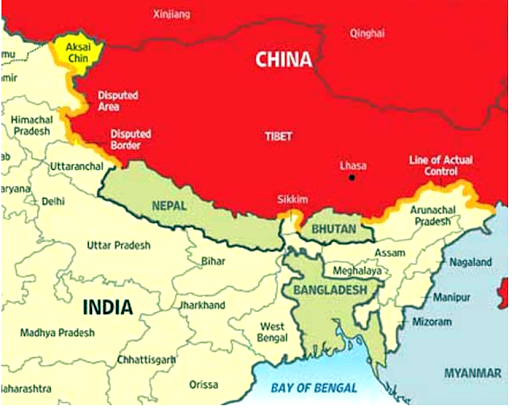
Recently, there have been reports of Chinese construction of three villages in Arunachal Pradesh 5 kilometres from the Bum La pass.
- Bum La Pass is one of the four officially agreed BPM (Border Personnel Meeting) points between the Indian Army and the People’s Liberation Army of China.
- Earlier in 2020, China had begun work on a strategically significant railway line that will link Sichuan province with Nyingchi in Tibet, which lies close to Arunachal Pradesh border.
Key Points
- About the New Village built Last Year:
- The satellite images, dated November 2020, show that a full-fledged village has been built on the banks of the River Tsari Chu in the Upper Subansiri district of Arunachal Pradesh.
- The village is located a couple of kilometres across the Line of Actual Control (LAC).
- China had earlier built a permanent construction of military barracks in this area.
- The area has been under Chinese control since 1959.
- It is at least 2 km south (in Indian territory) of the McMahon Line, which China doesn’t recognise. After the 1962 war, India stopped patrolling the area.
- China considers the McMahon Line illegal and unacceptable claiming that Tibetan representatives who had signed the 1914 Convention held in Shimla which delineated the McMahon line on the map were not having rights to do so.
- The satellite images, dated November 2020, show that a full-fledged village has been built on the banks of the River Tsari Chu in the Upper Subansiri district of Arunachal Pradesh.
- Other Spots of Disagreement:
- There are close to two dozen spots along the entire length of the Line of Actual Control (LAC) in all sectors where India and China do not agree on its alignment.
- Line of Actual Control:
- It is divided into three sectors:
- The eastern sector which spans Arunachal Pradesh and Sikkim (1346 km).
- The middle sector in Uttarakhand and Himachal Pradesh (545 km).
- The western sector in Ladakh (1597 km).
- The alignment of the LAC in the eastern sector is along the 1914 McMahon Line.
- It is divided into three sectors:
- Case of Arunachal Pradesh:
- India's claim line is different from that of the LAC. It is the line seen in the official boundary marked on the maps as released by the Survey of India, including Aksai Chin (occupied by China). The state of Arunachal Pradesh is an ‘integral and inalienable’ part of India.
- In China’s case, LAC corresponds mostly to its claim line, but in the eastern sector, it claims the entire Arunachal Pradesh as South Tibet.
- China’s Intention:
- The construction of the village has been seen by analysts as a move to bolster China’s claim to the area, and part of a broader recent push by China to build civilian settlements in disputed frontier areas, which it has also done with Bhutan.
- Implications on India:
- Security Concerns:
- A village near the border will largely improve the efficiency and convenience of military personnel and material transportation and logistical supplies in the border area.
- In situations of direct standoff near Arunachal Pradesh border, as was seen during Doklam or recent Ladakh standoff, China might be at an advantageous position.
- Doklam Issue: Indian troops intervened to block the path of Chinese soldiers engaged in building road-works on the Doklam plateau of Bhutan’s territory that Beijing laid claim.
- Security Concerns:
- Recent Steps Taken by India:
- India will spend 10% funds of the Border Area Development Programme (BADP) only to improve the infrastructure along the China border.
- The Border Roads Organisation (BRO) constructed the Daporijo bridge over Subansiri river in Arunachal Pradesh in a record span of just 27 days.
- It links roads leading upto the LAC between India and China.
- Recently the Defence Minister virtually laid the foundation of a tunnel at Nechiphu in West Kameng district of Arunachal Pradesh.
- It will shorten travel time for troops till the LAC through Tawang, which China claims to be its territory.
- The BRO is already constructing an all-weather tunnel under the Se La pass in Arunachal Pradesh which connects Tawang to the rest of Arunachal and Guwahati.
- The state government of Arunachal Pradesh has advocated selection of 10 census towns along the India-China border as pilot projects for infrastructure development in order to stop people living along its international borders, specifically with China, from migrating to faraway urban centres in the State.
- Recently, the Defence Minister inaugurated the Sisseri River Bridge located at lower Dibang Valley in Arunachal Pradesh connecting Dibang Valley and Siang.
- In 2019, the Indian Air Force inaugurated resurfaced runway at India’s easternmost Village-Vijaynagar (Changlang district) in Arunachal Pradesh.
- In 2019, the Indian Army conducted exercise ‘HimVijay’ in Arunachal Pradesh and Assam with its newly created Integrated Battle Groups (IBG).
- Bogibeel bridge, which is India’s longest road-rail bridge connecting Dibrugarh in Assam to Pasighat in Arunachal Pradesh was inaugurated in 2018.
- It will facilitate quicker movement of troops and equipment to areas near the India-China border.
Way Forward
- India needs to be vigilant enough for any new development in China near its border to protect its interests efficiently. Further, it needs to build robust Infrastructure in difficult border areas in its territory to ensure movement of personnel and other logistical supplies in an efficient manner.


